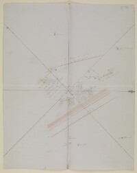
Sketch map of the central part of the Arabian Peninsula
Mss Eur F126/107, f 3
2 items in this record
Search within this record
The record is made up of 1 map. It was created in 1865. It was written in English. The original is part of the British Library: India Office The department of the British Government to which the Government of India reported between 1858 and 1947. The successor to the Court of Directors. Records and Private Papers Documents collected in a private capacity. .
About this record
- Content
Distinctive Features:
Hand drawn rough map of the central part of the Arabian Peninsula showing the approximate location of settlements in blue with Ad-Dahna Desert represented by red lines. Place names given in both English and Arabic inserted in pencil. Map is divided by a central compass rose orienting west to the top with 'quadrantal points' at 45 degrees to the four cardinal directions.
- Extent and format
- 1 map
- Area map covers
- Map loading...
- Scale
- Scale not given
- Scale designator
- Horizontal
- Orientation
- West
- Degree coordinates
- Top-left: 29° 30' 47.52" N, 39° 41' 24.72" E
Top-right: 29° 30' 47.52" N, 50° 17' 9.96" E
Bottom-left: 21° 16' 44.4" N, 39° 41' 24.72" E
Bottom-right: 21° 16' 44.4" N, 50° 17' 9.96" E - It is part of
- 8 imagesRef: Mss Eur F126/107
- Physical characteristics
Materials: Pen and ink on paper with additions in pencil and crayon
Dimensions: 500 x 400 mm
Watermark: The paper contains the watermark ‘T H Saunders, 1860'.
- Written in
- English in Latin script
- Type
- Map
Archive information for this record
- Original held at
- British Library: India Office The department of the British Government to which the Government of India reported between 1858 and 1947. The successor to the Court of Directors. Records and Private Papers Documents collected in a private capacity.
- Access conditions
Unrestricted
- Archive reference
- Mss Eur F126/107, f 3
- Date(s)
- 1865 (CE, Gregorian)
Access & Reference
History of this record
Use and share this record
- Share this record
- Cite this record in your research
Sketch map of the central part of the Arabian Peninsula, British Library: India Office Records and Private Papers, Mss Eur F126/107, f 3, in Qatar Digital Library <https://www.qdl.qa/archive/81055/vdc_100024376729.0x000002> [accessed 9 July 2026]
- Link to this record
https://www.qdl.qa/en/archive/81055/vdc_100024376729.0x000002
- IIIF details
This record has a IIIF manifest available as follows. If you have a compatible viewer you can drag the icon to load it.https://www.qdl.qa/en/iiif/81055/vdc_100000001524.0x0003de/manifestOpen in Universal viewerOpen in Mirador viewerMore options for embedding images
Copyright: How to use this content
- Reference
- Mss Eur F126/107, f 3
- Title
- Sketch map of the central part of the Arabian Peninsula
- Pages
- 3r:3v
- Author
- East India Company, the Board of Control, the India Office, or other British Government Department
- Usage terms
- Open Government Licence