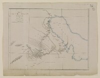
‘Map of Arabia Showing the route of Lieut. Col. Pelly’
Mss Eur F126/107, f 4
2 items in this record
Search within this record
The record is made up of 1 map. It was created in 1865. It was written in English. The original is part of the British Library: India Office The department of the British Government to which the Government of India reported between 1858 and 1947. The successor to the Court of Directors. Records and Private Papers Documents collected in a private capacity. .
About this record
- Content
Distinctive Features:
Relief shown by hachures Lines drawn on a map to indicate the direction and steepness of slope. .
Outline map of the northern part of the Arabian Peninsula produced by Edward Weller, F.R.G.S. [Fellow of the Royal Geographical Society] showing Sir Lewis’ Pelly travelled route with location of wells and forts marked.
- Extent and format
- 1 map
- Area map covers
- Map loading...
- Scale
- Scale approximately 1:5,000,000
- Scale designator
- Horizontal
- Orientation
- North
- Degree coordinates
- Top-left: 31° 8' 38.76" N, 41° 59' 50.64" E
Top-right: 31° 8' 38.76" N, 53° 16' 27.48" E
Bottom-left: 21° 46' 28.92" N, 41° 59' 50.64" E
Bottom-right: 21° 46' 28.92" N, 53° 16' 27.48" E - It is part of
- 8 imagesRef: Mss Eur F126/107
- Physical characteristics
Dimensions: 176 x 230 mm, 221 x 281 mm
- Written in
- English in Latin script
- Type
- Map
Archive information for this record
- Original held at
- British Library: India Office The department of the British Government to which the Government of India reported between 1858 and 1947. The successor to the Court of Directors. Records and Private Papers Documents collected in a private capacity.
- Access conditions
Unrestricted
- Archive reference
- Mss Eur F126/107, f 4
- Date(s)
- 1865 (CE, Gregorian)
Access & Reference
History of this record
Use and share this record
- Share this record
- Cite this record in your research
‘Map of Arabia Showing the route of Lieut. Col. Pelly’, British Library: India Office Records and Private Papers, Mss Eur F126/107, f 4, in Qatar Digital Library <https://www.qdl.qa/archive/81055/vdc_100024376729.0x000003> [accessed 2 August 2026]
- Link to this record
https://www.qdl.qa/en/archive/81055/vdc_100024376729.0x000003
- IIIF details
This record has a IIIF manifest available as follows. If you have a compatible viewer you can drag the icon to load it.https://www.qdl.qa/en/iiif/81055/vdc_100000001524.0x0003de/manifestOpen in Universal viewerOpen in Mirador viewerMore options for embedding images
Copyright: How to use this content
- Reference
- Mss Eur F126/107, f 4
- Title
- ‘Map of Arabia Showing the route of Lieut. Col. Pelly’
- Pages
- 4r:4v
- Author
- East India Company, the Board of Control, the India Office, or other British Government Department
- Usage terms
- Open Government Licence