!['A Map of Turkestan illustrating the travels of Arminius Vamberry in 1863' [‎1r] (1/2)](https://iiif.qdl.qa/iiif/images/81055/vdc_100000001524.0x0003db/Mss Eur F126_104_0001.jp2/full/!1200,1200/0/default.jpg "'A Map of Turkestan illustrating the travels of Arminius Vamberry in 1863' [‎1r] (1/2)")
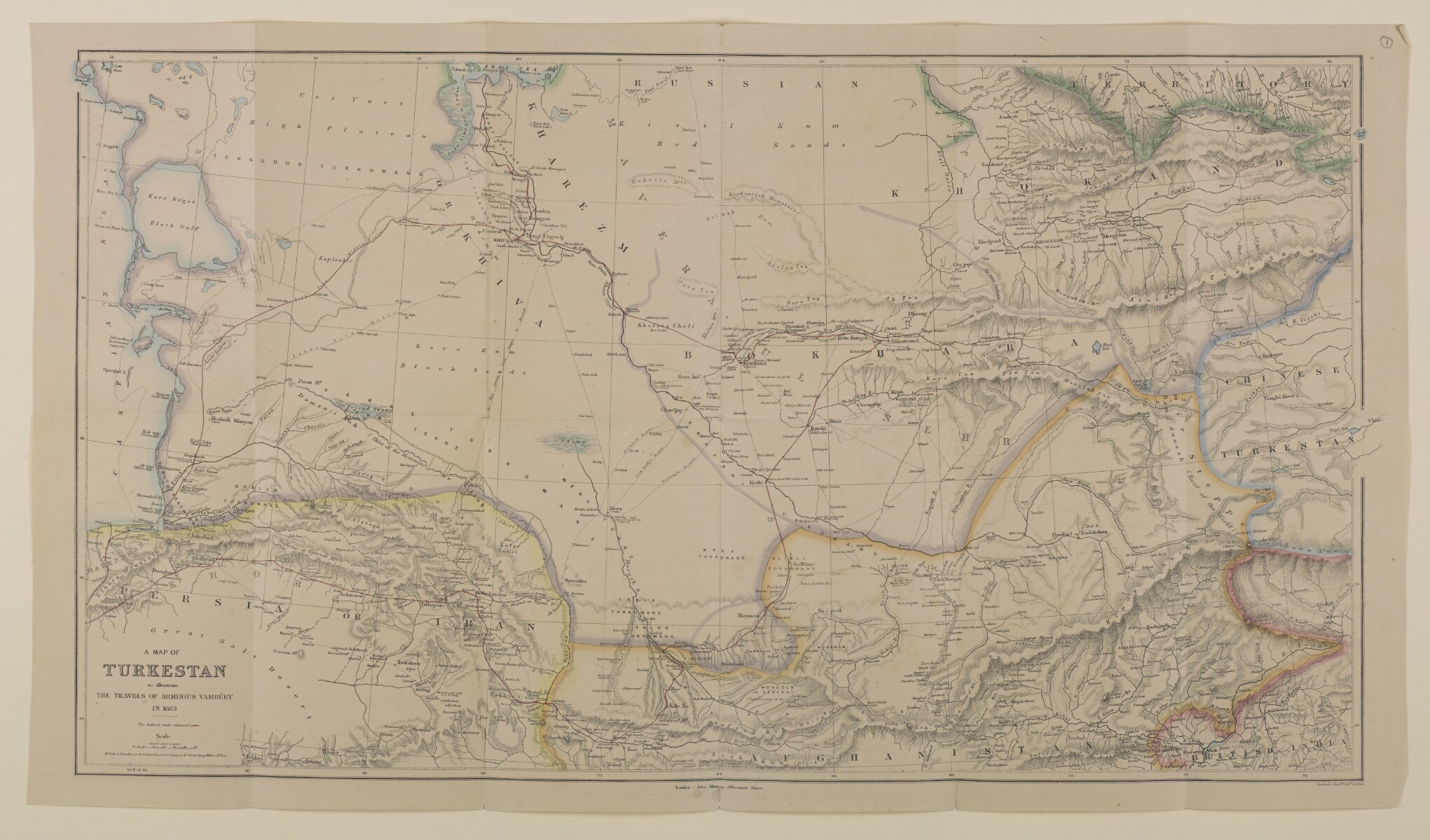
'A Map of Turkestan illustrating the travels of Arminius Vamberry in 1863' [1r] (1/2)
The record is made up of 1 map. It was created in 1863. It was written in English. The original is part of the British Library: India Office The department of the British Government to which the Government of India reported between 1858 and 1947. The successor to the Court of Directors. Records and Private Papers Documents collected in a private capacity. .
About this item
- Content
Imprint:
London, published by John Murray, Albermarle Street. Lithographed A lithograph is an image reproduced from a printing plate whose image areas attract ink and non-image areas repel it. by Stanfords Geog. Estab.
Distinctive Features:
Relief shown by hachures Lines drawn on a map to indicate the direction and steepness of slope. .
Shows the route of the author by red line.
The verso The back of a sheet of paper or leaf, often abbreviated to 'v'. of the folio contains the title 'Vamberry's map of Central Asia' written in Lewis Pelly's handwriting in pencil.
- Extent and format
- 1 map
- Area map covers
- Map loading...
- Scale
- Scale 1:3,168,000
- Scale designator
- Horizontal
- Orientation
- North
- Degree coordinates
- Top-left: 42° 42' 0" N, 52° 17' 60" E
Top-right: 42° 42' 0" N, 74° 29' 24" E
Bottom-left: 34° 11' 24" N, 52° 17' 60" E
Bottom-right: 34° 11' 24" N, 74° 29' 24" E - Physical characteristics
Dimensions: 351 x 660 mm; on sheet 393 x 687 mm
Foliation: The map sheet has been foliated in the front top right hand corner of the folio with a pencil number enclosed in a circle.
- Written in
- English in Latin script View the complete information for this record
Use and share this item
- Share this item
'A Map of Turkestan illustrating the travels of Arminius Vamberry in 1863' [1r] (1/2), British Library: India Office Records and Private Papers, Mss Eur F126/104, in Qatar Digital Library <https://www.qdl.qa/archive/81055/vdc_100024390741.0x000002> [accessed 28 June 2026]
https://www.qdl.qa/en/archive/81055/vdc_100024390741.0x000002
Copy and paste the code below into your web page where you would like to embed the image.
<meta charset="utf-8"><a href="https://www.qdl.qa/en/archive/81055/vdc_100024390741.0x000002">'A Map of Turkestan illustrating the travels of Arminius Vamberry in 1863' [‎1r] (1/2)</a> <a href="https://www.qdl.qa/en/archive/81055/vdc_100024390741.0x000002"> <img src="https://iiif.qdl.qa/iiif/images/81055/vdc_100000001524.0x0003db/Mss Eur F126_104_0001.jp2/full/!280,240/0/default.jpg" alt="" /> </a>
This record has a IIIF manifest available as follows. If you have a compatible viewer you can drag the icon to load it.https://www.qdl.qa/en/iiif/81055/vdc_100000001524.0x0003db/manifestOpen in Universal viewerOpen in Mirador viewerMore options for embedding images
Copyright: How to use this content
- Reference
- Mss Eur F126/104
- Title
- 'A Map of Turkestan illustrating the travels of Arminius Vamberry in 1863'
- Pages
- 1r:1v
- Author
- John Murray Publishers
- Usage terms
- Public Domain