!['ROUTES IN PERSIA, Section 1.' [‎22r] (48/416)](https://iiif.qdl.qa/iiif/images/81055/vdc_100000001491.0x000111/Mss Eur F111_369_0048.jp2/full/!1200,1200/0/default.jpg "'ROUTES IN PERSIA, Section 1.' [‎22r] (48/416)")
'ROUTES IN PERSIA, Section 1.' [22r] (48/416)
The record is made up of 1 volume (206 folios). It was created in 1898. It was written in English. The original is part of the British Library: India Office The department of the British Government to which the Government of India reported between 1858 and 1947. The successor to the Court of Directors. Records and Private Papers Documents collected in a private capacity. .
Transcription
This transcription is created automatically. It may contain errors.
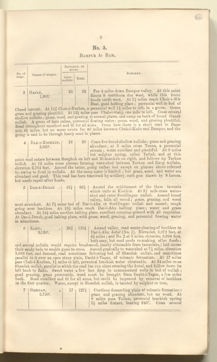
9
No. 3.
Bampur to Bam.
©
No. of
Htage.
Names of stages.
DlSTANCB, Ilf
miles.
Inter
mediate
Total.
Reuabks.
Gazak • . 25 52 For 4 miles down Bampur valley. At this point
Route 8 continues due west, while this route
bends north-west. At 7i miles reach Chah-i-Mir
Dost, good halting place ; perennial well in bed of
Cband torrent. At Ilf Chah-i-Durban, a perennial well 1| miles to left, in a grove. Green
grass and grazing plentiful. At 13§ miles pass Ohah-i-Ganj, one mile to left. Cross several
shallow nullahs ; grass, wood, and grazing at several places, and camp on bank of broad Gazak
nullah A grove of date palms, perennial flowing water; grass, wood, and grazing plentiful.
Road throughout excellent and fit for all arms, from here there is a short road to Bam
pur, 45 miles, but no water exists for 40 miles between Chah-i-Kodu and Bampur, and the
going is said to be through heavy sand in places.
Dab-i-Kishkin, 16 68 Cross five broad shallow nullahs ; grass and grazing
2 830'. abundant; at. 3 miles cross Tanna, a perennial
stream ; water excellent and plentiful. At 8 miles
hot sulphur spring, called Taftab, and at this
point road enters between Rangkoh on left and Maksankuh on right, and follows up Tarkan
nullah. At 12 miles cross plateau forming watershed between Tarkan and Rang nullahs,
elevation 2,764 feet. Ascend the latter, going rather bad except on plateau above referred
to, owing to flood in nullahs. At the camp space is limited ; but grass, wood, and water are
abundant and good. This road has been traversed by artillery, each gun drawn by 8 horses,
but needs repair after floods.
4
Dar-i-Dozab
151
831
Ascend the middlemost of the three torrents
which unite at Kishkin. At 2£ mile cross water
shed and enter Surtilingan nullah. Ascend broad
valley, hills all round; grass, grazing, and wood
most abundant. At 7§ enter bed of Dar-i-Ahu or Surtilingan nullah and ascend; rough
going over boulders. At 13£ miles reach Dar-i-Ahu halting place; water and grass
abundant. At 14$ miles another halting place, excellent camping-ground with all requisites.
At Dar-i-Dozab, good baiting place, with grass, wood, grazing, and perennial flowing water
in abundance.
6
Zahu,
3,C20'.
261
llOi
Ascend valley, road wants clearing of boulders to
Dar-i-Ahu Icoial (No. 1). Elevation 3,972 feet, at
4| miles ; and No. 2 at 5 miles, elevation 3,988 feet,
both easy, but road needs re-making after floods ;
and several nullahs would require brushwood, (easily obtainable from tamarisks,) laid across
their sandy beds to enable guns to cross. Ascend gradually to watershed at 7| miles, elevation
3,683 feet, and descend, road sometimes following bed of Shandak nullah, and sometimes
parallel to it over an open stony plain, Dasht-i-Tagaz, of volcanic formation. At 17 miles
pass Ohah-i-Kurban, 1| miles to left, perennial brackish water obtainable. At 24 miles cross
Shandak nullah, parallel to which the road has run since crossing the hotal, and follow down its
left bank to Zahu. Sweet water a few feet deep in extemporised wells in bed of nullah ;
good grazing, grass procurable, wood must be brought from Dasht-i-Tagaz, a few miles
back. Road excellent and fit for all arms, but could be improved by removal of boulders
in the first quarter. Water, except in Shandak nullah, is tainted by sulphur or iron.
7
Gehgan, .
17
127?
Continue descending plain of volcanic formation ;
2,750'.
grass and grazing abundant, but no wood. At
8 miles pass Tulian, perennial brackish spring
1| miles distant, bearing 246°. Cross several
About this item
- Content
The publication, Routes in Persia, Section I was compiled in the Intelligence Branch of the Quarter-Master Gerneral's Department in India and was published by the Office of the Superintendent of Government Printing, India, Calcutta: 1898.
Section I contains all the routes which commence from the Persian Gulf The historical term used to describe the body of water between the Arabian Peninsula and Iran. littoral and extending to a line drawn from Burajird [Borūjerd], through Isfahan [Eşfahān], Yazd, Karman [Kermān], Khabis [Khabīş], Neh to Lash Juwain [Lāsh-e Juwayn]; the routes have been arranged within the volume by starting from the sea base of the Persian Gulf The historical term used to describe the body of water between the Arabian Peninsula and Iran. and working up towards the line described.
For each route described the previous authorities, such as publications and accounts of journeys, are given, along with the following details:
- Names of stages: towns and villages which act as stopping points along the route;
- The distance in miles from the previous stage of the route;
- The total distance in miles for that route up to that stage;
- Remarks: including geographical information; details on smaller settlements; sacred places; condition of roads; access to water; other roads and routes.
The volume also includes two appendices which contain details of other routes for which the information was received too late to be included in the main body of the volume.
An ink stamp on the front cover records the confidential nature of the publication and that it was being transmitted for the information of His Excellency the Viceroy (Victor Alexander Bruce, 9th Earl of Elgin and 16th Earl of Kincardine) only.
The inside front and back covers have pockets containing index maps of the routes described in the volume.
- Extent and format
- 1 volume (206 folios)
- Arrangement
Folios 6-10 consist of an alphabetical index to names of places featured in the volume, excluding those places which appear in appendix II. Folios 11-17 are an alphabetical cross-index of the routes featured in the volume, again excluding those routes which appear in appendix II.
- Physical characteristics
Foliation: The foliation sequence commences at the front cover, and terminates at the inside back cover; these numbers are written in pencil, are circled, and are located in the top right corner of the recto The front of a sheet of paper or leaf, often abbreviated to 'r'. side of each folio. The volume aso contains an original printed pagination sequence.
- Written in
- English in Latin script View the complete information for this record
Use and share this item
- Share this item
'ROUTES IN PERSIA, Section 1.' [22r] (48/416), British Library: India Office Records and Private Papers, Mss Eur F111/369, in Qatar Digital Library <https://www.qdl.qa/archive/81055/vdc_100025705310.0x000031> [accessed 10 May 2024]
https://www.qdl.qa/en/archive/81055/vdc_100025705310.0x000031
Copy and paste the code below into your web page where you would like to embed the image.
<meta charset="utf-8"><a href="https://www.qdl.qa/en/archive/81055/vdc_100025705310.0x000031">'ROUTES IN PERSIA, Section 1.' [‎22r] (48/416)</a> <a href="https://www.qdl.qa/en/archive/81055/vdc_100025705310.0x000031"> <img src="https://iiif.qdl.qa/iiif/images/81055/vdc_100000001491.0x000111/Mss Eur F111_369_0048.jp2/full/!280,240/0/default.jpg" alt="" /> </a>
This record has a IIIF manifest available as follows. If you have a compatible viewer you can drag the icon to load it.https://www.qdl.qa/en/iiif/81055/vdc_100000001491.0x000111/manifestOpen in Universal viewerOpen in Mirador viewerMore options for embedding images
Copyright: How to use this content
- Reference
- Mss Eur F111/369
- Title
- 'ROUTES IN PERSIA, Section 1.'
- Pages
- front, back, spine, edge, head, tail, front-i, 2r:205v, back-i
- Author
- East India Company, the Board of Control, the India Office, or other British Government Department
- Usage terms
- Open Government Licence