!['ROUTES IN PERSIA, Section 1.' [‎36v] (77/416)](https://iiif.qdl.qa/iiif/images/81055/vdc_100000001491.0x000111/Mss Eur F111_369_0077.jp2/full/!1200,1200/0/default.jpg "'ROUTES IN PERSIA, Section 1.' [‎36v] (77/416)")
'ROUTES IN PERSIA, Section 1.' [36v] (77/416)
The record is made up of 1 volume (206 folios). It was created in 1898. It was written in English. The original is part of the British Library: India Office The department of the British Government to which the Government of India reported between 1858 and 1947. The successor to the Court of Directors. Records and Private Papers Documents collected in a private capacity. .
Transcription
This transcription is created automatically. It may contain errors.
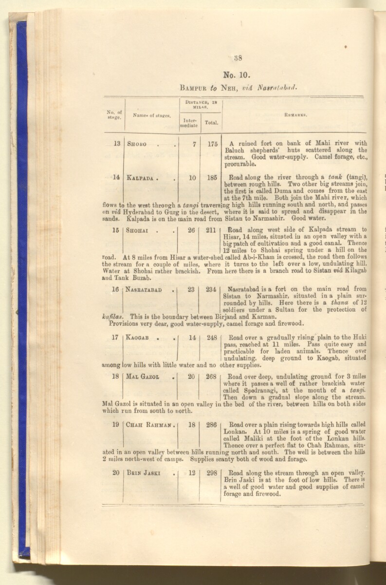
88
No. 10.
Bampur to Neh, via Nasrataba//.
No. of
singe.
Name* of staues.
Distance, in
MILfcS.
Inter
mediate
Kkmarks.
Total.
13
14
Shoho
Kalpada
flows to
10
175
185
A ruined fort on bank of Hahi river with
Baluch shepherds’ huts scattered along the
stream. Good water-supply. Camel forage, etc.,
procurable.
Road along the river through a tank (tangi),
between rough hills. Two other big streams join,
the first is called Duma and comes from the east
at the 7th mile. Both join the Mahi river, which
the west through a tangi traversing high hills running south and north, and passes
ftnvrr in daaarf. wViPTA if. is SAir! fn fiTVTPfld ATI A dlSaTinfiar ill til A
nuws me wesi. bnrougn a vanyi braversiug ui^u tuuuiu^ ouuoii. iawauu,
on vi& Hyderabad to Gurg in the desert, where it is said to spread and disappear in the
sands, kalpada is on the main road from Sistan to Narmashir. Good water.
15
Shohai
26
road.
211
Road along west side of Kalpada stream to
Hisar, 14 miles, situated in an open valley with a
big patch of cultivation and a good canal. Thence
12 miles to Shohai spring under a hill on the
At 8 miles from Hisar a water-shed called Ab-i-Kham is crossed, the road then follows
the stream for a couple of miles, where it turns to the left over a low, undulating hill.
Water at Shohai rather brackish. From here there is a branch road to Sistan via Kilagab
and Tank Buzab.
16
Nasratabad
23
234
Nasratabad is a fort on the main road from
Sistan to Narmashir, situated in a plain sur
rounded by hills. Here there is a thana of 12
soldiers under a Sultan for the protection of
kafilas. This is the boundary between Birjand and Karman.
Provisions very dear, good water-supply, camel forage and firewood.
17
Kaogab
14
248
Road over a gradually rising plain to the Huki
pass, reached at 11 miles. Pass quite easy and
practicable for laden animals. Thence over
undulating, deep ground to Kaogab, situated
among low hills with little water and no other supplies.
18
Mal Gazol
20
268
Road over deep, undulating ground for 3 miles
where it passes a well of rather brackish water
called Spedranagi, at the mouth of a tangi.
Then down a gradual slope along the stream.
Mal Gazol is situated in an open valley in the bed of the river, between hills on both sides
which run from south to north.
19
Chah Rahman.
18
286
Road over a plain rising towards high hills called
Lonkan. At 10 miles is a spring of good water
called Maliki at the foot of the Lonkan hills.
Thence over a perfect flat to Chah Rahman, situ
ated in an open valley between hills running north and south. The well is between the hills
2 miles north-west of camps. Supplies scanty both of wood and forage.
20 i Brin Jaski
12 298
Road along the stream through an open valley-
Brin Jaski is at the foot of low hills. There is
a well of good water and good supplies of camel
forage and firewood.
About this item
- Content
The publication, Routes in Persia, Section I was compiled in the Intelligence Branch of the Quarter-Master Gerneral's Department in India and was published by the Office of the Superintendent of Government Printing, India, Calcutta: 1898.
Section I contains all the routes which commence from the Persian Gulf The historical term used to describe the body of water between the Arabian Peninsula and Iran. littoral and extending to a line drawn from Burajird [Borūjerd], through Isfahan [Eşfahān], Yazd, Karman [Kermān], Khabis [Khabīş], Neh to Lash Juwain [Lāsh-e Juwayn]; the routes have been arranged within the volume by starting from the sea base of the Persian Gulf The historical term used to describe the body of water between the Arabian Peninsula and Iran. and working up towards the line described.
For each route described the previous authorities, such as publications and accounts of journeys, are given, along with the following details:
- Names of stages: towns and villages which act as stopping points along the route;
- The distance in miles from the previous stage of the route;
- The total distance in miles for that route up to that stage;
- Remarks: including geographical information; details on smaller settlements; sacred places; condition of roads; access to water; other roads and routes.
The volume also includes two appendices which contain details of other routes for which the information was received too late to be included in the main body of the volume.
An ink stamp on the front cover records the confidential nature of the publication and that it was being transmitted for the information of His Excellency the Viceroy (Victor Alexander Bruce, 9th Earl of Elgin and 16th Earl of Kincardine) only.
The inside front and back covers have pockets containing index maps of the routes described in the volume.
- Extent and format
- 1 volume (206 folios)
- Arrangement
Folios 6-10 consist of an alphabetical index to names of places featured in the volume, excluding those places which appear in appendix II. Folios 11-17 are an alphabetical cross-index of the routes featured in the volume, again excluding those routes which appear in appendix II.
- Physical characteristics
Foliation: The foliation sequence commences at the front cover, and terminates at the inside back cover; these numbers are written in pencil, are circled, and are located in the top right corner of the recto The front of a sheet of paper or leaf, often abbreviated to 'r'. side of each folio. The volume aso contains an original printed pagination sequence.
- Written in
- English in Latin script View the complete information for this record
Use and share this item
- Share this item
'ROUTES IN PERSIA, Section 1.' [36v] (77/416), British Library: India Office Records and Private Papers, Mss Eur F111/369, in Qatar Digital Library <https://www.qdl.qa/archive/81055/vdc_100025705310.0x00004e> [accessed 3 August 2026]
https://www.qdl.qa/en/archive/81055/vdc_100025705310.0x00004e
Copy and paste the code below into your web page where you would like to embed the image.
<meta charset="utf-8"><a href="https://www.qdl.qa/en/archive/81055/vdc_100025705310.0x00004e">'ROUTES IN PERSIA, Section 1.' [‎36v] (77/416)</a> <a href="https://www.qdl.qa/en/archive/81055/vdc_100025705310.0x00004e"> <img src="https://iiif.qdl.qa/iiif/images/81055/vdc_100000001491.0x000111/Mss Eur F111_369_0077.jp2/full/!280,240/0/default.jpg" alt="" /> </a>
This record has a IIIF manifest available as follows. If you have a compatible viewer you can drag the icon to load it.https://www.qdl.qa/en/iiif/81055/vdc_100000001491.0x000111/manifestOpen in Universal viewerOpen in Mirador viewerMore options for embedding images
Copyright: How to use this content
- Reference
- Mss Eur F111/369
- Title
- 'ROUTES IN PERSIA, Section 1.'
- Pages
- front, back, spine, edge, head, tail, front-i, 2r:205v, back-i
- Author
- East India Company, the Board of Control, the India Office, or other British Government Department
- Usage terms
- Open Government Licence