!['ROUTES IN PERSIA, Section 1.' [‎73v] (151/416)](https://iiif.qdl.qa/iiif/images/81055/vdc_100000001491.0x000111/Mss Eur F111_369_0151.jp2/full/!1200,1200/0/default.jpg "'ROUTES IN PERSIA, Section 1.' [‎73v] (151/416)")
'ROUTES IN PERSIA, Section 1.' [73v] (151/416)
The record is made up of 1 volume (206 folios). It was created in 1898. It was written in English. The original is part of the British Library: India Office The department of the British Government to which the Government of India reported between 1858 and 1947. The successor to the Court of Directors. Records and Private Papers Documents collected in a private capacity. .
Transcription
This transcription is created automatically. It may contain errors.
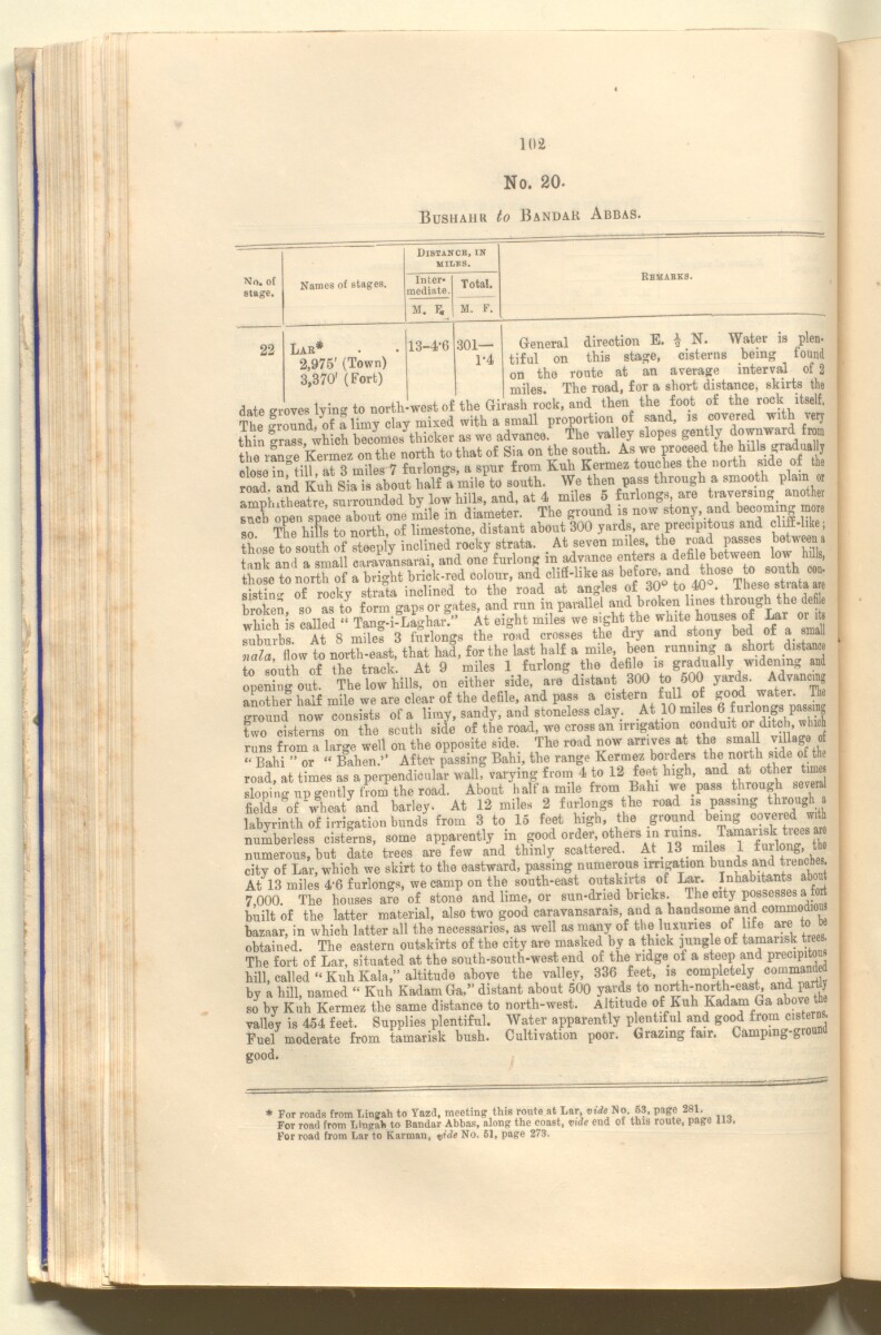
102
No. 20-
Bushahr to Bandar Abbas.
—
Distance, in
miles.
No. of
stage.
Names of stages.
Inter
mediate.
Total.
M. F.
M. F.
22
Lar*
2,975' (Town)
3,370' (Fort)
13-4-6
301—
1-4
Remakes.
direction E. | N. Water ia plen-
this stage, cisterns being found
route at an average interval of 2
General
tiful on
on the — —* -
miles. The road, for a short distance, skirts the
date groves lyin- to north-west of the Girash rock, and then the foot of the rock itself.
The Cnnd of^ Hmy clay mixed with a small proportion of sand, covered with very
thin " rass wh ch becomes thicker as we advance. The valley slopes gently downward from
the rlnte Kerlz on the north to that of Sia on the sonth. As we proceed the hills gradual y
c ose iniill aH miles 7 furlongs, a spur from Kuh Kermez touches the nortn side of the
road and Kuh Sia i about half a mile to south. We then pass through a smooth plain or
amphitheatre surrounded by low hills, and, at 4 miles 5 furlongs are traversing < another
such open space about one mile in diameter. The ground is now stony, and becoming more
so The hiFls to north, of limestone, distant about 300 yards, are precipitous and cliff-like;
those to south of steeply inclined rocky strata. At seven miles, the road passes between a
taXand a small caravansarai, and one furlong in advance enters a defile between low hi lie,
those to north of a bright brick-red colour, and clifi-hke as bef 0 ^
sistim' of rocky strata inclined to the road at angles of 30 to 40 . Ihesestiataa e
broken so as to form gaps or gates, and run in parallel and broken lines through the defi e
which is called “ Tang-i-Laghar.” At eight miles we sight the white houses of Lar or iU
suburbs. At 8 miles 3 furlongs the road crosses the dry and stony bed of a small
nala, flow to north-east, that had, % the last half a mde been running a ^tance
to south of
the track. At 9
The low hills, on
miles
either
1 furlong the defile is gradually widening
side, are distant 300 to 500 yards. Advancing
ground now consists of a limy, sandy, and stoneless clay. At 10 mfles 6 furlongs pass g
two cisterns on the south side of the road, we cross an irrigation conduit or ditch winch
runs from a large well on the opposite side. The road now arrives at the small village of
“ Bahi ” or “ Bahen.” After passing Bahi, the range Kermez borders the north side of the
road, at times as a perpendicular wall, varying from 4 to 12 feet high, and at other times
sloping up gently f rom the road. About half a mile from Bahi we pass through several
fields of wheat and barley. At 12 miles 2 furlongs the road is passing thiough
labyrinth of irrigation bunds from 3 to 15 feet high, the ground being covered with
numberless cisterns, some apparently m good order, others m ruins. Ta “ai 1 sk t iees aM
numerous, but date trees are few and thinly scattered. At 13 miles 1 fuilong, the
city of Lar, which we skirt to the eastward, passing numerous irrigation bunds and trenches
At 13 miles 4‘6 furlongs, we camp on the south-east outskirts of Lar. Inhabitants a
7,000. The houses are of stone and lime, or sun-dried bricks. The city possesses a fort
built of the latter material, also two good caravansarais, and a handsome and commodiou
bazaar, in which latter all the necessaries, as well as many of the luxuries of life are to be
obtained. The eastern outskirts of the city are masked by a thick pingle of tamansk trees.
The fort of Lar, situated at the south-south-west end of the ridge of a steep and precipito
hill, called “ Kuh Kala,” altitude above the valley, 336 feet, is completely comman
by a hill, named “ Kuh Kadam Ga,” distant about 500 yards to north-north-east, and partly
so by Kuh Kermez the same distance to north-west. Altitude of Kuh Kadam Ga above t
valley is 454 feet. Supplies plentiful. Water apparently plentiful and good from cistern.
Fuel moderate from tamarisk bush. Cultivation poor. Grazing fair. Camping-gioun
good.
For roads from Ling ah to Yazd, meeting this route at Lar No 63, page 281
For road from Lingah to Bandar Abbas, along the coast, vide end of this route, page 113.
For road from Lar to Karman, qide No. 61, page 273,
About this item
- Content
The publication, Routes in Persia, Section I was compiled in the Intelligence Branch of the Quarter-Master Gerneral's Department in India and was published by the Office of the Superintendent of Government Printing, India, Calcutta: 1898.
Section I contains all the routes which commence from the Persian Gulf The historical term used to describe the body of water between the Arabian Peninsula and Iran. littoral and extending to a line drawn from Burajird [Borūjerd], through Isfahan [Eşfahān], Yazd, Karman [Kermān], Khabis [Khabīş], Neh to Lash Juwain [Lāsh-e Juwayn]; the routes have been arranged within the volume by starting from the sea base of the Persian Gulf The historical term used to describe the body of water between the Arabian Peninsula and Iran. and working up towards the line described.
For each route described the previous authorities, such as publications and accounts of journeys, are given, along with the following details:
- Names of stages: towns and villages which act as stopping points along the route;
- The distance in miles from the previous stage of the route;
- The total distance in miles for that route up to that stage;
- Remarks: including geographical information; details on smaller settlements; sacred places; condition of roads; access to water; other roads and routes.
The volume also includes two appendices which contain details of other routes for which the information was received too late to be included in the main body of the volume.
An ink stamp on the front cover records the confidential nature of the publication and that it was being transmitted for the information of His Excellency the Viceroy (Victor Alexander Bruce, 9th Earl of Elgin and 16th Earl of Kincardine) only.
The inside front and back covers have pockets containing index maps of the routes described in the volume.
- Extent and format
- 1 volume (206 folios)
- Arrangement
Folios 6-10 consist of an alphabetical index to names of places featured in the volume, excluding those places which appear in appendix II. Folios 11-17 are an alphabetical cross-index of the routes featured in the volume, again excluding those routes which appear in appendix II.
- Physical characteristics
Foliation: The foliation sequence commences at the front cover, and terminates at the inside back cover; these numbers are written in pencil, are circled, and are located in the top right corner of the recto The front of a sheet of paper or leaf, often abbreviated to 'r'. side of each folio. The volume aso contains an original printed pagination sequence.
- Written in
- English in Latin script View the complete information for this record
Use and share this item
- Share this item
'ROUTES IN PERSIA, Section 1.' [73v] (151/416), British Library: India Office Records and Private Papers, Mss Eur F111/369, in Qatar Digital Library <https://www.qdl.qa/archive/81055/vdc_100025705310.0x000098> [accessed 7 May 2024]
https://www.qdl.qa/en/archive/81055/vdc_100025705310.0x000098
Copy and paste the code below into your web page where you would like to embed the image.
<meta charset="utf-8"><a href="https://www.qdl.qa/en/archive/81055/vdc_100025705310.0x000098">'ROUTES IN PERSIA, Section 1.' [‎73v] (151/416)</a> <a href="https://www.qdl.qa/en/archive/81055/vdc_100025705310.0x000098"> <img src="https://iiif.qdl.qa/iiif/images/81055/vdc_100000001491.0x000111/Mss Eur F111_369_0151.jp2/full/!280,240/0/default.jpg" alt="" /> </a>
This record has a IIIF manifest available as follows. If you have a compatible viewer you can drag the icon to load it.https://www.qdl.qa/en/iiif/81055/vdc_100000001491.0x000111/manifestOpen in Universal viewerOpen in Mirador viewerMore options for embedding images
Copyright: How to use this content
- Reference
- Mss Eur F111/369
- Title
- 'ROUTES IN PERSIA, Section 1.'
- Pages
- front, back, spine, edge, head, tail, front-i, 2r:205v, back-i
- Author
- East India Company, the Board of Control, the India Office, or other British Government Department
- Usage terms
- Open Government Licence