!['ROUTES IN PERSIA, Section 1.' [‎91v] (187/416)](https://iiif.qdl.qa/iiif/images/81055/vdc_100000001491.0x000111/Mss Eur F111_369_0187.jp2/full/!1200,1200/0/default.jpg "'ROUTES IN PERSIA, Section 1.' [‎91v] (187/416)")
'ROUTES IN PERSIA, Section 1.' [91v] (187/416)
The record is made up of 1 volume (206 folios). It was created in 1898. It was written in English. The original is part of the British Library: India Office The department of the British Government to which the Government of India reported between 1858 and 1947. The successor to the Court of Directors. Records and Private Papers Documents collected in a private capacity. .
Transcription
This transcription is created automatically. It may contain errors.
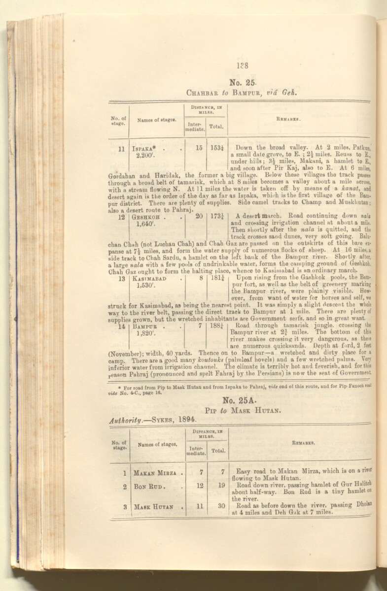
1?8
No. 25-
Chahbau to Bampur, via Geh.
No. of
fctage.
Names of stages.
Distance, in
miles.
Inter
mediate.
Total.
Rbmakks .
11
ISPAKA*
2 , 200 '.
15
153*
12
Geshkoh .
20
173*
1,640'.
Down the broad valley. At 2 miles, Patkun,
a small date grove, to E. ; 2§ miles, Eeuss to E.,
under hills; 3^ miles, Makani, a hamlet to E.,
and soon after Pir Kaj, also to E. At 6 miles,
Gordahan and Haridak, the former a big village. Below these villages the track passes
through a broad belt of tamarisk, which at 8 miles becomes a valley about a mile across,
with a stream flowing N. At 1 1 miles the water is taken off by means of a kanat, and
desert again is the order of the day as far as Ispaka, which is the first village of the Bam
pur district. There are plenty of supplies. Side camel tracks to Champ and Muskhutan;
also a desert route to Pahraj.
A desert march. Road continuing down nala
and crossing irrigation channel at about a mile.
Then shortly after the nala is quitted, and the
track crosses sand dunes, very soft going. Balu-
chan Chah (not Luchan Chah) and Chah (Jaz are passed on the outskirts of this bare ex
panse at miles, and form the water supply of numerous flocks of sheep. At 16 miles, a
side track to Chah Sardu, a hamlet on the left bank of the Bampur river. Shortly after,
a large nala with a few pools of undrinkable water, forms the camping ground of Geshkoh.
Chah'Gaz ought to form the halting place, whence to Kasimabad is an ordinary march.
Kasimabad . 8 181* Upon rising from the Gashkok pools, the Bam-
1,530'. pur fort, as well as the belt of greenery marking
the Bampur river, were plainly visible. How
ever, from want of water for horses and self, we
struck for Kasimabad, as being the nearest point. It was simply a slight descent the whole
way to the river belt, passing the direct track to Bampur at 1 mile. There are plenty of
sunplies grown, but the wretched inhabitants are Government serfs, and so in great want.
14 Bampur . . 7 188* Road through tamarisk jungle, crossing the
Bampur river at 2* miles. The bottom of this
river makes crossing it very dangerous, as there
are numerous quicksands. Depth at ford, 2 feet
(November); width, 40 yards. Thence on to Bampur—a wretched and dirty place for a
camp. There area good many koutouks (palmleaf hovels) and a few wretched palms. Very
inferior water from irrigation channel. The climate is terribly hot and feverish, and for this
r eason Pahraj (pronounced and spelt Fahraj by the Persians) is now the seat of Government.
13
Bampur .
7
188*
1,820'.
* For road from Pip to Mask Hutan and from Ispaka to Pahraj, vide end of this route, and for Pip Fanoch road
lide No. 4-C., page 16.
No. 25A.
Pip to Mask Hutan.
No. of
stage.
Distance, in
miles.
Names of stages.
Inter
mediate.
Total.
Remabkb.
1
Makan Mibza .
7
7
Easy road to Makan Mirza, which is on a river
flowing to Mask Hutan.
2
Bon Rud .
12
19
Road down river, passing hamlet of Gur Halitch
about half-way. Bon Rud is a tiny hamlet on
the river.
3
Mask Hutan .
1
11
30
Road as before down the river, passing Dholan
at 4 miles and Deh Gak at 7 miles. .
About this item
- Content
The publication, Routes in Persia, Section I was compiled in the Intelligence Branch of the Quarter-Master Gerneral's Department in India and was published by the Office of the Superintendent of Government Printing, India, Calcutta: 1898.
Section I contains all the routes which commence from the Persian Gulf The historical term used to describe the body of water between the Arabian Peninsula and Iran. littoral and extending to a line drawn from Burajird [Borūjerd], through Isfahan [Eşfahān], Yazd, Karman [Kermān], Khabis [Khabīş], Neh to Lash Juwain [Lāsh-e Juwayn]; the routes have been arranged within the volume by starting from the sea base of the Persian Gulf The historical term used to describe the body of water between the Arabian Peninsula and Iran. and working up towards the line described.
For each route described the previous authorities, such as publications and accounts of journeys, are given, along with the following details:
- Names of stages: towns and villages which act as stopping points along the route;
- The distance in miles from the previous stage of the route;
- The total distance in miles for that route up to that stage;
- Remarks: including geographical information; details on smaller settlements; sacred places; condition of roads; access to water; other roads and routes.
The volume also includes two appendices which contain details of other routes for which the information was received too late to be included in the main body of the volume.
An ink stamp on the front cover records the confidential nature of the publication and that it was being transmitted for the information of His Excellency the Viceroy (Victor Alexander Bruce, 9th Earl of Elgin and 16th Earl of Kincardine) only.
The inside front and back covers have pockets containing index maps of the routes described in the volume.
- Extent and format
- 1 volume (206 folios)
- Arrangement
Folios 6-10 consist of an alphabetical index to names of places featured in the volume, excluding those places which appear in appendix II. Folios 11-17 are an alphabetical cross-index of the routes featured in the volume, again excluding those routes which appear in appendix II.
- Physical characteristics
Foliation: The foliation sequence commences at the front cover, and terminates at the inside back cover; these numbers are written in pencil, are circled, and are located in the top right corner of the recto The front of a sheet of paper or leaf, often abbreviated to 'r'. side of each folio. The volume aso contains an original printed pagination sequence.
- Written in
- English in Latin script View the complete information for this record
Use and share this item
- Share this item
'ROUTES IN PERSIA, Section 1.' [91v] (187/416), British Library: India Office Records and Private Papers, Mss Eur F111/369, in Qatar Digital Library <https://www.qdl.qa/archive/81055/vdc_100025705310.0x0000bc> [accessed 29 July 2026]
https://www.qdl.qa/en/archive/81055/vdc_100025705310.0x0000bc
Copy and paste the code below into your web page where you would like to embed the image.
<meta charset="utf-8"><a href="https://www.qdl.qa/en/archive/81055/vdc_100025705310.0x0000bc">'ROUTES IN PERSIA, Section 1.' [‎91v] (187/416)</a> <a href="https://www.qdl.qa/en/archive/81055/vdc_100025705310.0x0000bc"> <img src="https://iiif.qdl.qa/iiif/images/81055/vdc_100000001491.0x000111/Mss Eur F111_369_0187.jp2/full/!280,240/0/default.jpg" alt="" /> </a>
This record has a IIIF manifest available as follows. If you have a compatible viewer you can drag the icon to load it.https://www.qdl.qa/en/iiif/81055/vdc_100000001491.0x000111/manifestOpen in Universal viewerOpen in Mirador viewerMore options for embedding images
Copyright: How to use this content
- Reference
- Mss Eur F111/369
- Title
- 'ROUTES IN PERSIA, Section 1.'
- Pages
- front, back, spine, edge, head, tail, front-i, 2r:205v, back-i
- Author
- East India Company, the Board of Control, the India Office, or other British Government Department
- Usage terms
- Open Government Licence