!['ROUTES IN PERSIA, Section 1.' [‎121v] (247/416)](https://iiif.qdl.qa/iiif/images/81055/vdc_100000001491.0x000111/Mss Eur F111_369_0247.jp2/full/!1200,1200/0/default.jpg "'ROUTES IN PERSIA, Section 1.' [‎121v] (247/416)")
'ROUTES IN PERSIA, Section 1.' [121v] (247/416)
The record is made up of 1 volume (206 folios). It was created in 1898. It was written in English. The original is part of the British Library: India Office The department of the British Government to which the Government of India reported between 1858 and 1947. The successor to the Court of Directors. Records and Private Papers Documents collected in a private capacity. .
Transcription
This transcription is created automatically. It may contain errors.
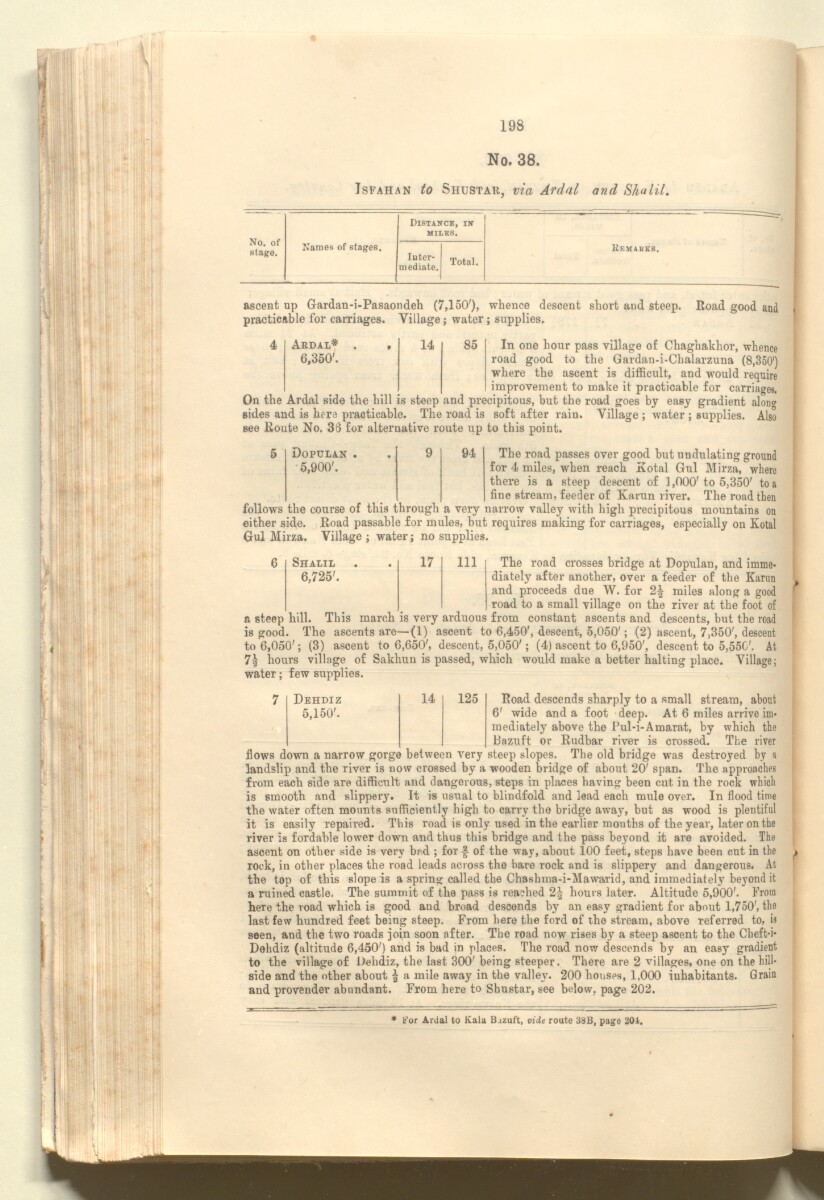
* For Ardal to Kala B-izuft, vide route 38B, page 201.
198
No. 38.
Isfahan to Shustar, via Ardal
and Sh<i lit .
No. of
stage.
Distance, in
miles.
Names of stages.
Jnter- T » ,
mediate. 10ta1,
Remakes.
ascent up Gardan-i-Pasaondeh (7,150'), whence d
practicable for carriages. Village; water; supplies.
Road good at
4
Ardal* . .
14
85
6,350'.
Dopulan .
9
94
5,900'.
Shalil
17
111
6,725'.
In one hour pass village of Chaghakhor, whence
road good to the Gardan-i-Chalarzuna (8,350')
where the ascent is difficult, and would require
improvement to make it practicable for c trriagee.
On the Ardal side the hill is steep and precipitous, but the road goes by easy gradient alono
sides and is here practicable. The road is soft after rain. Village ; water ; supplies. Also
see Route No. 35 for alternative route up to this point.
The road passes over good but undulating ground
for 4 miles, when reach Kotal Gul Mirza, where
there is a steep descent of 1,000'to 5,350' to a
fine stream, feeder of Karun river. The road then
follows the course of this through a very narrow valley with high precipitous mountains on
either side. Road passable for mules, but requires making for carriages, especially on Kotal
Gul Mirza. Village ; water; no supplies.
The road crosses bridge at Dopulan, and imme
diately after another, over a feeder of the Karun
and proceeds due W. for 2| miles along a good
road to a small village on the river at the foot of
a steep hill. This march is very arduous from constant ascents and descents, but the road
is good. The ascents are—(1) ascent to 6,450', descent, 5,050'; (2) ascent, 7,350', descent
to 6,050'; (3) ascent to 6,650', descent, 5,050'; (4) ascent to 6,950', descent to 5,55C'. At
7\ hours village of Sakhun is passed, which would make a better halting place. Village;
water; few supplies.
Road descends sharply to a small stream, about
6' wide and a foot deep. At 6 miles arrive im
mediately above the Pul-i-Amarat, by which the
Bazuft or Rudbar river is crossed. The river
flows down a narrow gorge between very steep slopes. The old bridge was destroyed by a
landslip and the river is now crossed by a wooden bridge of about 20' span. The approaches
from each side are difficult and dangerous, steps in places having been cut in the rock which
is smooth and slippery. It is usual to blindfold and lead each mule over. In flood time
the water often mounts sufficiently high to carry the bridge awa} 7 , but as wood is plentiful
it is easily repaired. This road is only used in the earlier mouths of the year, later on the
river is fordable lower down and thus this bridge and the pass beyond it are avoided. The
ascent on other side is very bad ; for of the way, about 100 feet, steps have been cut in the
rock, in other places the road leads across the bare rock and is slippery and dangerous. At
the top of this slope is a spring called the Chashma-i-Mawarid, and immediately beyond it
a ruined castle. The summit of the pass is reached 2^ hours later. Altitude 5,900'. From
here the road which is good and broad descends by an easy gradient for about 1,750', the
last few hundred feet being steep. From here the ford of the stream, above referred to, is
seen, and the two roads join soon after. The road now rises by a steep ascent to the Cheft-i-
Dehdiz (altitude 6,450') and is bad in places. The road now descends by an easy gradient
to the village of Dehdiz, the last 300' being steeper. There are 2 villages, one on the hill
side and the other about | a mile away in the valley. 200 houses, 1,000 inhabitants. Grain
and provender abundant. From here to Shustar, see below, page 202.
Dehdiz
14
125
5,150'.
About this item
- Content
The publication, Routes in Persia, Section I was compiled in the Intelligence Branch of the Quarter-Master Gerneral's Department in India and was published by the Office of the Superintendent of Government Printing, India, Calcutta: 1898.
Section I contains all the routes which commence from the Persian Gulf The historical term used to describe the body of water between the Arabian Peninsula and Iran. littoral and extending to a line drawn from Burajird [Borūjerd], through Isfahan [Eşfahān], Yazd, Karman [Kermān], Khabis [Khabīş], Neh to Lash Juwain [Lāsh-e Juwayn]; the routes have been arranged within the volume by starting from the sea base of the Persian Gulf The historical term used to describe the body of water between the Arabian Peninsula and Iran. and working up towards the line described.
For each route described the previous authorities, such as publications and accounts of journeys, are given, along with the following details:
- Names of stages: towns and villages which act as stopping points along the route;
- The distance in miles from the previous stage of the route;
- The total distance in miles for that route up to that stage;
- Remarks: including geographical information; details on smaller settlements; sacred places; condition of roads; access to water; other roads and routes.
The volume also includes two appendices which contain details of other routes for which the information was received too late to be included in the main body of the volume.
An ink stamp on the front cover records the confidential nature of the publication and that it was being transmitted for the information of His Excellency the Viceroy (Victor Alexander Bruce, 9th Earl of Elgin and 16th Earl of Kincardine) only.
The inside front and back covers have pockets containing index maps of the routes described in the volume.
- Extent and format
- 1 volume (206 folios)
- Arrangement
Folios 6-10 consist of an alphabetical index to names of places featured in the volume, excluding those places which appear in appendix II. Folios 11-17 are an alphabetical cross-index of the routes featured in the volume, again excluding those routes which appear in appendix II.
- Physical characteristics
Foliation: The foliation sequence commences at the front cover, and terminates at the inside back cover; these numbers are written in pencil, are circled, and are located in the top right corner of the recto The front of a sheet of paper or leaf, often abbreviated to 'r'. side of each folio. The volume aso contains an original printed pagination sequence.
- Written in
- English in Latin script View the complete information for this record
Use and share this item
- Share this item
'ROUTES IN PERSIA, Section 1.' [121v] (247/416), British Library: India Office Records and Private Papers, Mss Eur F111/369, in Qatar Digital Library <https://www.qdl.qa/archive/81055/vdc_100025705311.0x000030> [accessed 7 May 2024]
https://www.qdl.qa/en/archive/81055/vdc_100025705311.0x000030
Copy and paste the code below into your web page where you would like to embed the image.
<meta charset="utf-8"><a href="https://www.qdl.qa/en/archive/81055/vdc_100025705311.0x000030">'ROUTES IN PERSIA, Section 1.' [‎121v] (247/416)</a> <a href="https://www.qdl.qa/en/archive/81055/vdc_100025705311.0x000030"> <img src="https://iiif.qdl.qa/iiif/images/81055/vdc_100000001491.0x000111/Mss Eur F111_369_0247.jp2/full/!280,240/0/default.jpg" alt="" /> </a>
This record has a IIIF manifest available as follows. If you have a compatible viewer you can drag the icon to load it.https://www.qdl.qa/en/iiif/81055/vdc_100000001491.0x000111/manifestOpen in Universal viewerOpen in Mirador viewerMore options for embedding images
Copyright: How to use this content
- Reference
- Mss Eur F111/369
- Title
- 'ROUTES IN PERSIA, Section 1.'
- Pages
- front, back, spine, edge, head, tail, front-i, 2r:205v, back-i
- Author
- East India Company, the Board of Control, the India Office, or other British Government Department
- Usage terms
- Open Government Licence