!['ROUTES IN PERSIA, Section 1.' [‎158v] (321/416)](https://iiif.qdl.qa/iiif/images/81055/vdc_100000001491.0x000111/Mss Eur F111_369_0321.jp2/full/!1200,1200/0/default.jpg "'ROUTES IN PERSIA, Section 1.' [‎158v] (321/416)")
'ROUTES IN PERSIA, Section 1.' [158v] (321/416)
The record is made up of 1 volume (206 folios). It was created in 1898. It was written in English. The original is part of the British Library: India Office The department of the British Government to which the Government of India reported between 1858 and 1947. The successor to the Court of Directors. Records and Private Papers Documents collected in a private capacity. .
Transcription
This transcription is created automatically. It may contain errors.
♦For Dizak to Paskuh, see next page, No. 49E.
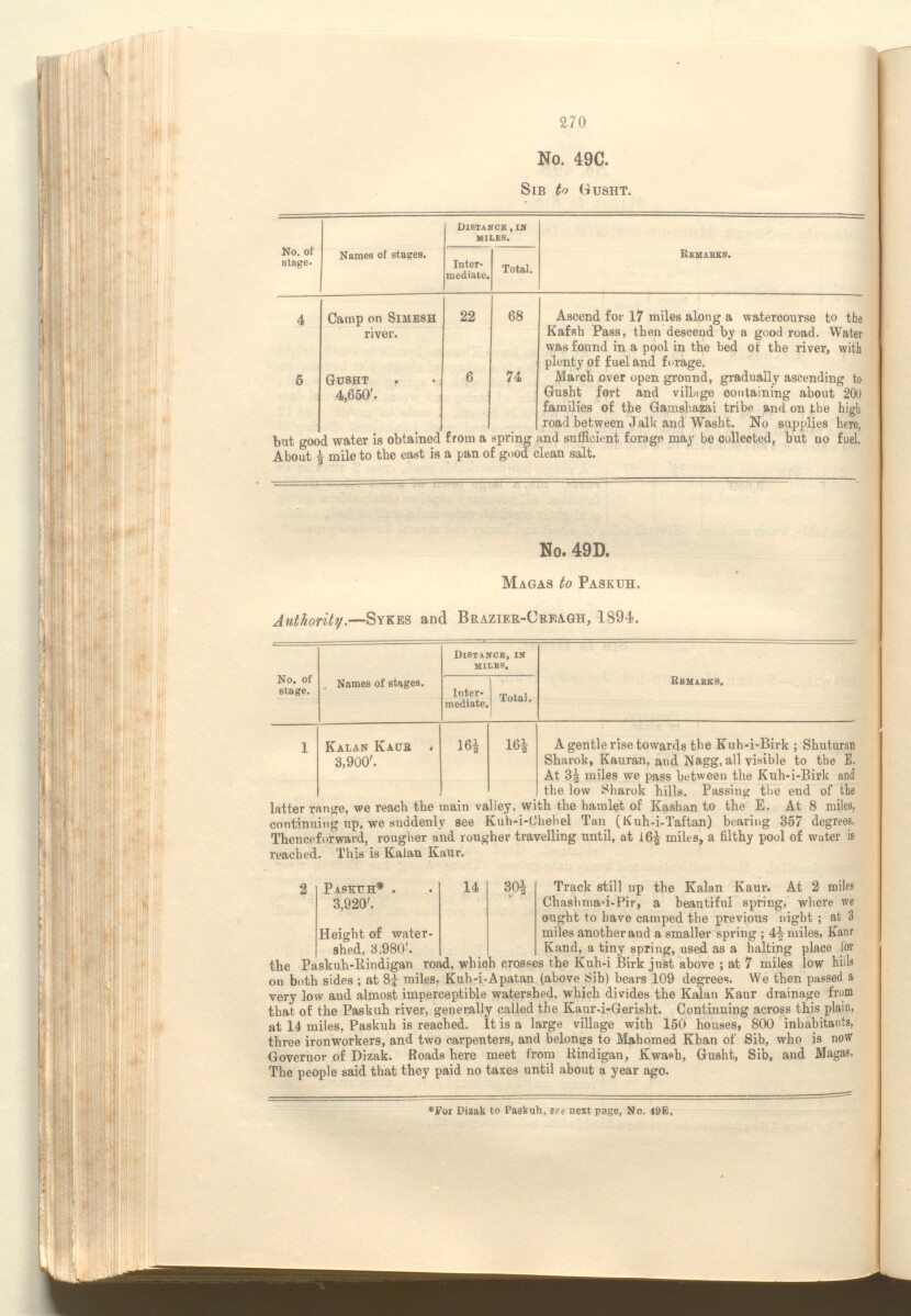
270
No. 49C.
Sib t» (tusht.
No. of
stage*
Names of stages.
Distance , in
miles.
Inter
mediate.
Total.
Remabks.
4
Camp on Simesh
river.
Gusht
4,650'.
22
68
74
Ascend for 17 miles along a watercourse to the
Kafsh Pass, then descend by a good road. Water
was found in a pool in the bed of the river, with
plenty of fuel and forage.
March over open ground, gradually ascending to
Gusht fort and village containing about 200
families of the Gamshazai tribe and on the high
road between Jalk and Washt. No supplies here,
but good water is obtained from a spring and sufficient forage may be collected, but no fuel.
About £ mile to the east is a pan of good clean salt.
No. 49D.
Magas to Paskuh.
Sykes and Brazier-Cbeagh, 1894.
No. of
stage.
Names of stages.
Distance, in
miles.
Rbmabks.
Inter
mediate.
Total.
1
Kalan Kade t
3,900'.
16|
I 65
A gentle rise towards the Kuh-i-Birk ; Shuturan
Sharok, Kauran, and Nagg, all visible to the E.
At 3| miles we pass between the Kuh-i*Birk and
the low Sharok hills. Passing the end of the
latter range, we reach the main valley, with the hamlet of Kashan to the E. At 8 miles,
continuing up, we suddenly see Kuh-i-Chehel Tan (Kuh-i-Taftan) bearing 357 degrees.
Thenceforward, rougher and rougher travelling until, at 16^ miles, a filthy pool of water is
reached. This is Kalan Kaur.
2 Papkuh* . . 14 30| Track still up the Kalan Kaur. At 2 miles
3,920’. Chashmad-Pir, a beautiful spring, where we
ought to have camped the previous night ; at 3
Height of water- miles another and a smaller spring ; 4| miles, Kaur
shed, 3.980'. Kand, a tiny spring, used as a halting place lor
the Paskuh-ltindigan road, which crosses the Kuh-i Birk just above ; at 7 miles low hills
on both sides ; at 83 - miles, Kuh-i-Apatan (above Sib) bears 109 degrees. We then passed a
very low and almost imperceptible watershed, which divides the Kalan Kaur drainage from
that of the Paskuh river, generally called the Kaur-i-Gerisht. Continuing across this plain,
at 14 miles, Paskuh is reached. It is a large village with 150 houses, 800 inhabitants,
three ironworkers, and two carpenters, and belongs to Mahomed Khan of Sib, who is^ now
Governor of Dizak. Roads here meet from Rindigan, Kw'ash, Gusht, Sib, and
The people said that they paid no taxes until about a year ago.
About this item
- Content
The publication, Routes in Persia, Section I was compiled in the Intelligence Branch of the Quarter-Master Gerneral's Department in India and was published by the Office of the Superintendent of Government Printing, India, Calcutta: 1898.
Section I contains all the routes which commence from the Persian Gulf The historical term used to describe the body of water between the Arabian Peninsula and Iran. littoral and extending to a line drawn from Burajird [Borūjerd], through Isfahan [Eşfahān], Yazd, Karman [Kermān], Khabis [Khabīş], Neh to Lash Juwain [Lāsh-e Juwayn]; the routes have been arranged within the volume by starting from the sea base of the Persian Gulf The historical term used to describe the body of water between the Arabian Peninsula and Iran. and working up towards the line described.
For each route described the previous authorities, such as publications and accounts of journeys, are given, along with the following details:
- Names of stages: towns and villages which act as stopping points along the route;
- The distance in miles from the previous stage of the route;
- The total distance in miles for that route up to that stage;
- Remarks: including geographical information; details on smaller settlements; sacred places; condition of roads; access to water; other roads and routes.
The volume also includes two appendices which contain details of other routes for which the information was received too late to be included in the main body of the volume.
An ink stamp on the front cover records the confidential nature of the publication and that it was being transmitted for the information of His Excellency the Viceroy (Victor Alexander Bruce, 9th Earl of Elgin and 16th Earl of Kincardine) only.
The inside front and back covers have pockets containing index maps of the routes described in the volume.
- Extent and format
- 1 volume (206 folios)
- Arrangement
Folios 6-10 consist of an alphabetical index to names of places featured in the volume, excluding those places which appear in appendix II. Folios 11-17 are an alphabetical cross-index of the routes featured in the volume, again excluding those routes which appear in appendix II.
- Physical characteristics
Foliation: The foliation sequence commences at the front cover, and terminates at the inside back cover; these numbers are written in pencil, are circled, and are located in the top right corner of the recto The front of a sheet of paper or leaf, often abbreviated to 'r'. side of each folio. The volume aso contains an original printed pagination sequence.
- Written in
- English in Latin script View the complete information for this record
Use and share this item
- Share this item
'ROUTES IN PERSIA, Section 1.' [158v] (321/416), British Library: India Office Records and Private Papers, Mss Eur F111/369, in Qatar Digital Library <https://www.qdl.qa/archive/81055/vdc_100025705311.0x00007a> [accessed 26 April 2024]
https://www.qdl.qa/en/archive/81055/vdc_100025705311.0x00007a
Copy and paste the code below into your web page where you would like to embed the image.
<meta charset="utf-8"><a href="https://www.qdl.qa/en/archive/81055/vdc_100025705311.0x00007a">'ROUTES IN PERSIA, Section 1.' [‎158v] (321/416)</a> <a href="https://www.qdl.qa/en/archive/81055/vdc_100025705311.0x00007a"> <img src="https://iiif.qdl.qa/iiif/images/81055/vdc_100000001491.0x000111/Mss Eur F111_369_0321.jp2/full/!280,240/0/default.jpg" alt="" /> </a>
This record has a IIIF manifest available as follows. If you have a compatible viewer you can drag the icon to load it.https://www.qdl.qa/en/iiif/81055/vdc_100000001491.0x000111/manifestOpen in Universal viewerOpen in Mirador viewerMore options for embedding images
Copyright: How to use this content
- Reference
- Mss Eur F111/369
- Title
- 'ROUTES IN PERSIA, Section 1.'
- Pages
- front, back, spine, edge, head, tail, front-i, 2r:205v, back-i
- Author
- East India Company, the Board of Control, the India Office, or other British Government Department
- Usage terms
- Open Government Licence