!['ROUTES IN PERSIA, Section 1.' [‎182r] (368/416)](https://iiif.qdl.qa/iiif/images/81055/vdc_100000001491.0x000111/Mss Eur F111_369_0368.jp2/full/!1200,1200/0/default.jpg "'ROUTES IN PERSIA, Section 1.' [‎182r] (368/416)")
'ROUTES IN PERSIA, Section 1.' [182r] (368/416)
The record is made up of 1 volume (206 folios). It was created in 1898. It was written in English. The original is part of the British Library: India Office The department of the British Government to which the Government of India reported between 1858 and 1947. The successor to the Court of Directors. Records and Private Papers Documents collected in a private capacity. .
Transcription
This transcription is created automatically. It may contain errors.
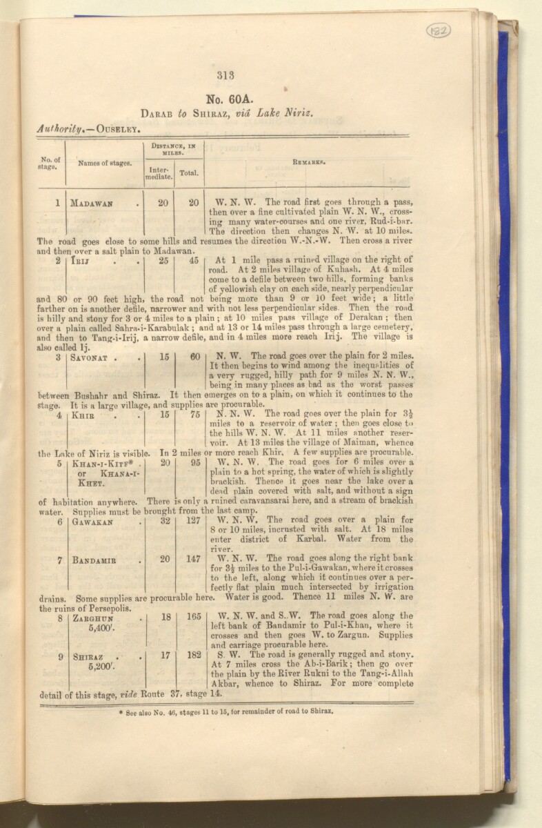
313
No. 60A.
Darab to Shiraz, via Lake Niriz.
Authority,—OusmaWi'
No. of
stage.
Distance, in
miles.
Names of stages.
Inter
mediate.
Total.
Remarks.
1
Madawan
20
20
W. N. W. The road first goes through a pass,
then over a fine cultivated plain W. N. W., cross
ing many water-courses and one river, Rud-i-bar.
The direction then changes N. W. at 10 miles.
The road goes close to some hills and resumes the directioa W.-N.*VV. Then cross a river
and then over a salt plain to Madawan
2
Ieij
25
45
At 1 mile pass a ruined village on the right of
road. At 2 miles village of Kuhash. At 4 miles
come to a defile between two hills, forming hanks
of yellowish clay on each side, nearly perpendicular
and 80 or 90 feet high, the road not being more than 9 or 10 feet wide; a little
farther on is another defile, narrower and with not less perpendicular sides Then the road
is hilly and stony for 3 or 4 miles to a plain ; at 10 miles pass village of Derakan ; then
over a plain called Sahra.i-Karabulak ; and at 13 or 14 miles pass through a large cemetery,
and then to Tang-i-Irij, a narrow defile, and in 4 miles more reach Irij. The village is
also called Ij.
N. W. The road goes over the plain for 2 miles.
It then begins to wind among the inequalities of
a very rugged, hilly path for 9 miles N. N. W.,
being in many places as bad as the worst passes
between Bushahr and Shiraz. It then emerges on to a plain, on which it continues to the
stage. It is a large village, and supplies are procurable.
3
Savonat
15
60
4
Khir
the Lake of Niriz is visible.
15 75 N- N. W. The road goes oyer the plain for 3|
miles to a reservoir of water ; then goes close to
the hills W. N. W. At 11 miles another reser
voir. At 13 miles the village of Maiman, whence
In 2 miles or more reach Khir, A few supplies are procurable.
Khan-i-Kitf*
or Khana-i-
Khet.
20
95
W. N. W. The road goes for 6 miles over a
plain to a hot spring, the water of which is slightly
brackish. Thence it goes near the lake over a
dead plain covered with salt, and without a sign
There is only a ruined caravansarai here, and a stream of brackish
6
of habitation anywhere.
water. Supplies must be brought trom the last camp.
W. N. W. The road goes over a plain for
8 or 10 miles, incrusted with salt. At 18 miles
enter district of Karbal. Water from the
river.
W. N. W. The road goes along the right bank
for 3| miles to the Pul-i-Gawakan, where it crosses
to the left, along which it continues over a per
fectly flat plain much intersected by irrigation
Some supplies are procurable here. Water is good. Thence 11 miles N. W. are
Gawakan
32
127
Bandamir
20
147
drains.
the ruins of Persepolis.
8
9
Zaeghpn
5,400'.
Shikaz
5,200'.
18
17
165
W. N. W. and S..W. The road goes along the
left bank of Bandamir to Pul-i-Kban, where it
crosses and then goes W. to Zargun. Supplies
and carriage procurable here.
S. W. The road is generally rugged and stony.
At 7 miles cross the Ab-i-Barik; then go over
the plain by the River Rukni to the Tang-i-Allah
Akbar, whence to Shiraz. For more complete
detail of this stage, vide Route 37, stage 14.
182
* See also No. 46, stages 11 to 15, (or remainder of road to Shiraz.
About this item
- Content
The publication, Routes in Persia, Section I was compiled in the Intelligence Branch of the Quarter-Master Gerneral's Department in India and was published by the Office of the Superintendent of Government Printing, India, Calcutta: 1898.
Section I contains all the routes which commence from the Persian Gulf The historical term used to describe the body of water between the Arabian Peninsula and Iran. littoral and extending to a line drawn from Burajird [Borūjerd], through Isfahan [Eşfahān], Yazd, Karman [Kermān], Khabis [Khabīş], Neh to Lash Juwain [Lāsh-e Juwayn]; the routes have been arranged within the volume by starting from the sea base of the Persian Gulf The historical term used to describe the body of water between the Arabian Peninsula and Iran. and working up towards the line described.
For each route described the previous authorities, such as publications and accounts of journeys, are given, along with the following details:
- Names of stages: towns and villages which act as stopping points along the route;
- The distance in miles from the previous stage of the route;
- The total distance in miles for that route up to that stage;
- Remarks: including geographical information; details on smaller settlements; sacred places; condition of roads; access to water; other roads and routes.
The volume also includes two appendices which contain details of other routes for which the information was received too late to be included in the main body of the volume.
An ink stamp on the front cover records the confidential nature of the publication and that it was being transmitted for the information of His Excellency the Viceroy (Victor Alexander Bruce, 9th Earl of Elgin and 16th Earl of Kincardine) only.
The inside front and back covers have pockets containing index maps of the routes described in the volume.
- Extent and format
- 1 volume (206 folios)
- Arrangement
Folios 6-10 consist of an alphabetical index to names of places featured in the volume, excluding those places which appear in appendix II. Folios 11-17 are an alphabetical cross-index of the routes featured in the volume, again excluding those routes which appear in appendix II.
- Physical characteristics
Foliation: The foliation sequence commences at the front cover, and terminates at the inside back cover; these numbers are written in pencil, are circled, and are located in the top right corner of the recto The front of a sheet of paper or leaf, often abbreviated to 'r'. side of each folio. The volume aso contains an original printed pagination sequence.
- Written in
- English in Latin script View the complete information for this record
Use and share this item
- Share this item
'ROUTES IN PERSIA, Section 1.' [182r] (368/416), British Library: India Office Records and Private Papers, Mss Eur F111/369, in Qatar Digital Library <https://www.qdl.qa/archive/81055/vdc_100025705311.0x0000a9> [accessed 17 April 2024]
https://www.qdl.qa/en/archive/81055/vdc_100025705311.0x0000a9
Copy and paste the code below into your web page where you would like to embed the image.
<meta charset="utf-8"><a href="https://www.qdl.qa/en/archive/81055/vdc_100025705311.0x0000a9">'ROUTES IN PERSIA, Section 1.' [‎182r] (368/416)</a> <a href="https://www.qdl.qa/en/archive/81055/vdc_100025705311.0x0000a9"> <img src="https://iiif.qdl.qa/iiif/images/81055/vdc_100000001491.0x000111/Mss Eur F111_369_0368.jp2/full/!280,240/0/default.jpg" alt="" /> </a>
This record has a IIIF manifest available as follows. If you have a compatible viewer you can drag the icon to load it.https://www.qdl.qa/en/iiif/81055/vdc_100000001491.0x000111/manifestOpen in Universal viewerOpen in Mirador viewerMore options for embedding images
Copyright: How to use this content
- Reference
- Mss Eur F111/369
- Title
- 'ROUTES IN PERSIA, Section 1.'
- Pages
- front, back, spine, edge, head, tail, front-i, 2r:205v, back-i
- Author
- East India Company, the Board of Control, the India Office, or other British Government Department
- Usage terms
- Open Government Licence