![File 37/1905 Pt 5 'Aden Delimitation' [‎93v] (191/606)](https://iiif.qdl.qa/iiif/images/81055/vdc_100000000365.0x000398/IOR_L_PS_10_67_0199.jp2/full/!1200,1200/0/default.jpg "File 37/1905 Pt 5 'Aden Delimitation' [‎93v] (191/606)")
File 37/1905 Pt 5 'Aden Delimitation' [93v] (191/606)
The record is made up of 1 volume (300 folios). It was created in 1905-1907. It was written in English, French and Arabic. The original is part of the British Library: India Office The department of the British Government to which the Government of India reported between 1858 and 1947. The successor to the Court of Directors. Records and Private Papers Documents collected in a private capacity. .
Transcription
This transcription is created automatically. It may contain errors.
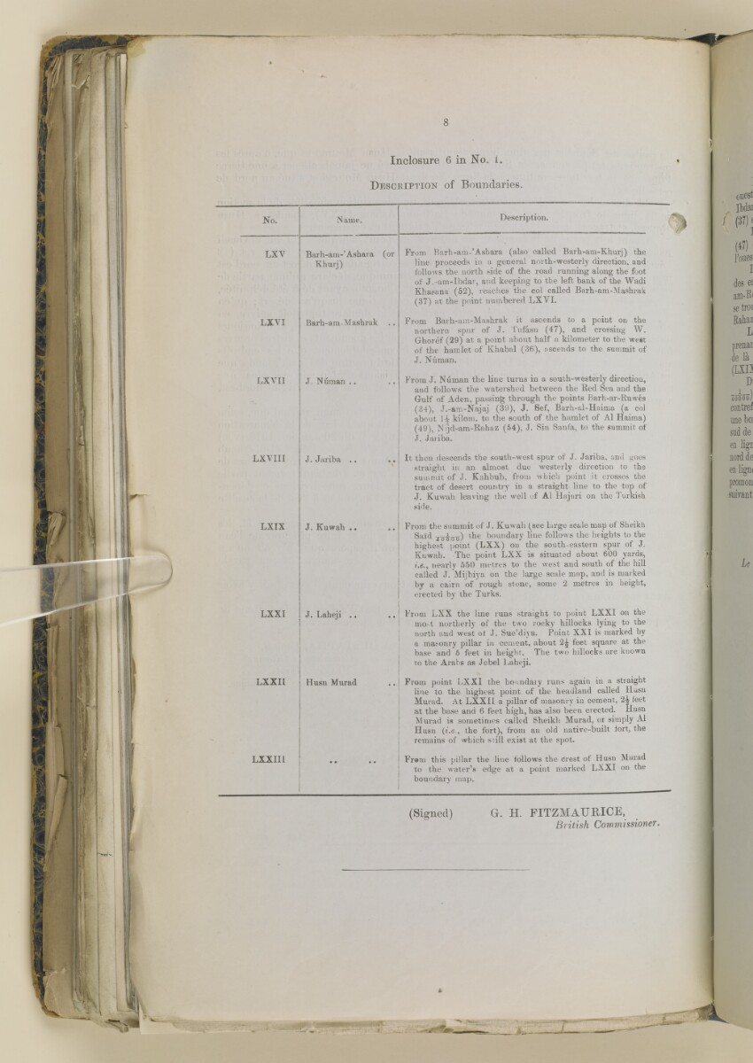
8
Inclosure 6 in No. i.
f
Description of Boundaries.
No.
Name.
Description.
LXV
Barh-am-’Ashara (or
Khurj)
From Barh-am-’Asbara (also called Barh-am-Khurj) the
line proceeds in a general north-westerly direction, and
follows the north side of the road running along the foot
of J.-am-Ibdar, and keeping to the left bank of the
Wadi
A seasonal or intermittent watercourse, or the valley in which it flows.
Khasana (52), reaches the col called Barh-am-Mashrak
(37) at the point numbered LXVI.
LX VI
Barh-ara-Mashrak ..
From Barh-am-Mashrak it ascends to a point on the
northern spur of J. Tufasu (47), and crossing W.
Ghoref (29) at a point about half a kilometer to the west
of the hamlet of Khabal (36), ascends to the summit of
J. Numan.
LXVI1
J Numan ..
From J. Numan the line turns in a south-westerly direction,
and follows the watershed between the Red Sea and the
Gulf of Aden, passing through the points Rarh-ar-Ruwes
(34), J.-am-Najaj (39), J. Sef, Barh-al-Haima (a col
about H kilom. to the south of the hamlet of Al Haima)
(49), N ijd-am-Rahaz (54), J. Sin Sanfa, to the summit of
J. Jariba.
LXVIII
J. Jariba ..
*
It then descends the south-west spur of J. Jariba, and goes
straight in an almost due westerly direction to the
summit of J. Kahbub, from which point it crosses the
tract of desert country in a straight line to the top of
J. Kuwah leaving the well of Al Hajari on the Turkish
side.
LXIX
J. Kuwab ..
From the summit of J. Kuwah (see large scale map of Sheikh
Said joioo) l ^ e boundary line follows the heights to the
highest point (LXX) on the south-eastern spur of J.
Kuwah. The point LXX is situated about 600 yards,
f.e., nearly 550 metres to the west and south of the hill
called J. Mijbiya on the large scale map, and is marked
by a cairn of rough stone, some 2 metres in height,
erected by the Turks.
LXXI
J. Laheji .. ..
From LXX the line runs straight to point LXXI on the
mo-t northerly of the two rocky hillocks lying to the
north and west of J. Sue’diya. Point XXI is marked by
a masonry pillar in cement, about 2^ feet square at the
base and 6 feet in height. The two hillocks are known
to the Arabs as Jebel Laheji.
LXXII
Husn Murad
From point LXXI the boundary runs again in a straight
line to the highest point of the headland called Husn
Murad. At LXXIL a pillar of masonry in cement, 2-^ feet
at the base and 6 feet high, has also been erected. Husn
Murad is sometimes called Sheikh Murad, or simply Al
Husn (i.e., the fort), from an old native-built fort, the
remains of which still exist at the spot.
LXXII1
• •
Fr®m this pillar the line follows the crest of Husn Murad
to the water’s edge at a point marked LXXI on the
boundary map.
1
(Signed) G. H. FITZM ATI RICE,
British Commissioner.
i
About this item
- Content
This file contains correspondence between British officials regarding the delineation of the border between the British Protectorate of Aden and the Ottoman Vilayet of Yemen.
Much of the correspondence is between officials at the Foreign Office and the India Office The department of the British Government to which the Government of India reported between 1858 and 1947. The successor to the Court of Directors. . Much of the correspondence relates to negotiations between the British and the Ottoman Empire and the work of the Anglo-Turkish Boundary Commission (under Colonel Robert Alexander Wahab and Colonel Mustapha Remzi Bey). The file contains some copies of correspondence in French that were sent to Ottoman officials in the course of negotiations.
The file contains seven maps, the details of which are as follows:
- a series of four maps entitled 'South Arabia, Anglo-Turkish Boundary' Sheets 1-4 (folios 43-46);
- a printed map entitled 'Map of Subaihi Border' with place names in English and Arabic (folio 120);
- a printed map of the Shekh Sa'id [Sheikh Said] Peninsula (folio 121);
- a printed map entitled 'Sketch Map of Aden Boundary' (folio 276).
The volume includes a divider which gives the year that the subject file was opened, the subject heading, and a list of correspondence references contained in it arranged by year. This divider is placed at the front of the volume.
- Extent and format
- 1 volume (300 folios)
- Arrangement
The papers are arranged in approximate chronological order from the front to the rear of the file.
The Subject 37 (Aden) contains 5 files, IOR/L/PS/10/63-67.
- Physical characteristics
Foliation: the foliation sequence commences at the inside front cover with 1 and terminates at the inside back cover with 300; these numbers are written in pencil, are circled, and are located in the top right corner of the recto The front of a sheet of paper or leaf, often abbreviated to 'r'. side of each folio.
- Written in
- English, French and Arabic in Latin and Arabic script View the complete information for this record
Use and share this item
- Share this item
File 37/1905 Pt 5 'Aden Delimitation' [93v] (191/606), British Library: India Office Records and Private Papers, IOR/L/PS/10/67, in Qatar Digital Library <https://www.qdl.qa/archive/81055/vdc_100027828891.0x0000c0> [accessed 4 May 2024]
https://www.qdl.qa/en/archive/81055/vdc_100027828891.0x0000c0
Copy and paste the code below into your web page where you would like to embed the image.
<meta charset="utf-8"><a href="https://www.qdl.qa/en/archive/81055/vdc_100027828891.0x0000c0">File 37/1905 Pt 5 'Aden Delimitation' [‎93v] (191/606)</a> <a href="https://www.qdl.qa/en/archive/81055/vdc_100027828891.0x0000c0"> <img src="https://iiif.qdl.qa/iiif/images/81055/vdc_100000000365.0x000398/IOR_L_PS_10_67_0199.jp2/full/!280,240/0/default.jpg" alt="" /> </a>
This record has a IIIF manifest available as follows. If you have a compatible viewer you can drag the icon to load it.https://www.qdl.qa/en/iiif/81055/vdc_100000000365.0x000398/manifestOpen in Universal viewerOpen in Mirador viewerMore options for embedding images
Copyright: How to use this content
- Reference
- IOR/L/PS/10/67
- Title
- File 37/1905 Pt 5 'Aden Delimitation'
- Pages
- front, back, spine, edge, head, tail, front-i, 2r:42v, 47r:119v, 122r:275v, 277r:280v, 280ar:280av, 281r:299v, back-i
- Author
- East India Company, the Board of Control, the India Office, or other British Government Department
- Usage terms
- Open Government Licence