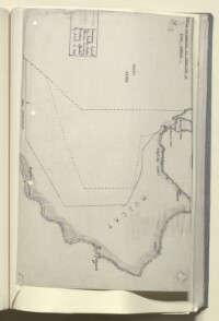
‘Sketch illustrating S.E. frontier of Saudi Arabia’
IOR/R/15/2/465, f 169
2 items in this record
Search within this record
The record is made up of 1 facsimile sketch map. It was created in 1948. It was written in English. The original is part of the British Library: India Office The department of the British Government to which the Government of India reported between 1858 and 1947. The successor to the Court of Directors. Records and Private Papers Documents collected in a private capacity. .
About this record
- Content
The map is a facsimile of a sketch map showing the eastern half of the Arabian peninsula, and indicating: with a solid line, the boundary claimed by Saudi Arabia; in a short-dashed black line, the Ottoman (Turkish) boundary (1913-14); and in a long-dashed line, the boundary offered by the British Government to the Saudi Arabia Government in 1937. The map is referred to by a confidential memorandum contained in the volume entitled ‘The South-Eastern Frontier of Saudi Arabia’, and dated 2 February 1948 (ff 164-168).
- Extent and format
- 1 facsimile sketch map
- Area map covers
- Map loading...
- Orientation
- North
- Degree coordinates
- Top-left: 25° 45' 0" N, 43° 53' 60" E
Top-right: 25° 45' 0" N, 60° 34' 48" E
Bottom-left: 15° 17' 24" N, 43° 53' 60" E
Bottom-right: 15° 17' 24" N, 60° 34' 48" E - It is part of
- 430 imagesRef: IOR/R/15/2/465
- Physical characteristics
Materials : Paper
Dimensions: 210 x 325 mm
Foliation : The map has two folio numbers in its top left corner. Circled number 169 should be used for referencing purposes. The other folio number has been crossed out and should be disregarded.
Binding: The map is bound into the volume, along its bottom edge.
- Written in
- English in Latin script
- Type
- Map
Archive information for this record
- Original held at
- British Library: India Office The department of the British Government to which the Government of India reported between 1858 and 1947. The successor to the Court of Directors. Records and Private Papers Documents collected in a private capacity.
- Access conditions
Unrestricted
- Archive reference
- IOR/R/15/2/465, f 169
- Date(s)
- 1948 (CE, Gregorian)
Access & Reference
History of this record
Use and share this record
- Share this record
- Cite this record in your research
‘Sketch illustrating S.E. frontier of Saudi Arabia’, British Library: India Office Records and Private Papers, IOR/R/15/2/465, f 169, in Qatar Digital Library <https://www.qdl.qa/archive/81055/vdc_100028545818.0x000003> [accessed 3 August 2026]
- Link to this record
https://www.qdl.qa/en/archive/81055/vdc_100028545818.0x000003
- IIIF details
This record has a IIIF manifest available as follows. If you have a compatible viewer you can drag the icon to load it.https://www.qdl.qa/en/iiif/81055/vdc_100000000241.0x000280/manifestOpen in Universal viewerOpen in Mirador viewerMore options for embedding images
Copyright: How to use this content
- Reference
- IOR/R/15/2/465, f 169
- Title
- ‘Sketch illustrating S.E. frontier of Saudi Arabia’
- Pages
- 169r:169v
- Author
- East India Company, the Board of Control, the India Office, or other British Government Department
- Usage terms
- Open Government Licence