!['GAZETTEER OF PERSIA. VOLUME IV.' [‎204r] (412/652)](https://iiif.qdl.qa/iiif/images/81055/vdc_100025472711.0x000001/IOR_L_MIL_17_15_2_3_0412.jp2/full/!1200,1200/0/default.jpg "'GAZETTEER OF PERSIA. VOLUME IV.' [‎204r] (412/652)")
'GAZETTEER OF PERSIA. VOLUME IV.' [204r] (412/652)
The record is made up of 1 volume (322 folios). It was created in 1910. It was written in English. The original is part of the British Library: India Office The department of the British Government to which the Government of India reported between 1858 and 1947. The successor to the Court of Directors. Records and Private Papers Documents collected in a private capacity. .
Transcription
This transcription is created automatically. It may contain errors.
MAK—MAK
399
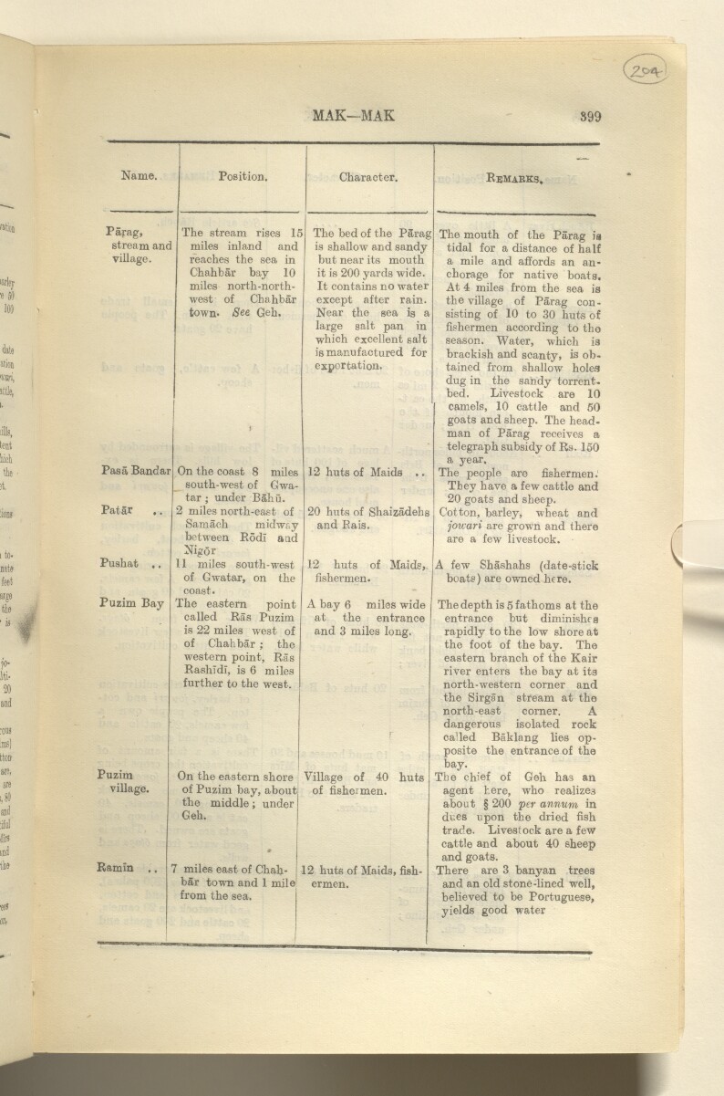
Name.
Position.
Character.
Remarks,
Parag,
The stream rises IS
The bed of the PSrag
The mouth of the Parag is
stream and
miles inland and
is shallow and sandy
tidal for a distance of half
village.
reaches the sea in
Chahbar bay 10
miles north-north
west of Chahbar
town* See Geh.
i
but near its mouth
it is 200 yards wide.
It contains no water
except after rain.
Near the sea is a
large salt pan in
which excellent salt
is manufactured for
exportation.
a mile and affords an an
chorage for native boats.
At 4 miles from the sea is
the village of Parag con
sisting of 10 to 30 huts of
fishermen according to the
season. Water, which is
brackish and scanty, is ob
tained from shallow holes
dug in the sandy torrent-
bed. Livestock are 10
camels, 10 cattle and 50
goats and sheep. The head
man of Parag receives a
telegraph subsidy of Rs. 150
a year.
Pas a 13andar
On the coast 8 miles
south-west of Gwa-
tar ; under Bahu.
12 huts of Maids ..
The people are fishermen.
They have a few cattle and
20 goats and sheep.
Pat ar ..
2 miles north-east of
Samach midway
between Rod! a ad
Nigor
20 hixts of Shaizadehs
and Rais.
Cotton, barley, wheat and
joicari are grown and there
are a few livestock.
Pushat ..
11 miles south-west
of Gwatar, on the
coast.
12 huts of Maids,
fishermen.
A few Shashahs (date-stick
boats) are owned here.
Puzim Bay
The eastern point
called Ras Puzim
is 22 miles west of
of Chahbar ; the
western point, Ras
Rashidi, is 6 miles
further to the west.
A bay 6 miles wide
at the entrance
and 3 miles long.
The depth is 5 fathoms at the
entrance but diminishes
rapidly to the low shore at
the foot of the bay. The
eastern branch of the Kair
river enters the bay at its
north-western corner and
the Sirgan stream at the
north-east corner. A
dangerous isolated rock
called Baklang lies op
posite the entrance of the
bay.
Puzim
On the eastern shore
Village of 40 huts
The chief of Geh has an
village.
of Puzim bay, about
the middle; under
Geh.
»
of fishermen.
agent here, who realizes
about § 200 per annum in
dues upon the dried fish
trade. Livestock are a few
cattle and about 40 sheep
and goats.
Ramin ..
7 miles east of Chah
bar town and 1 mile
from the sea.
12 huts of Maids, fish
ermen.
There are 3
banyan
Merchant of Indian extraction.
trees
and an old stone-lined well,
believed to be Portuguese,
yields good water
About this item
- Content
The item is Volume IV of the four-volume Gazetteer of Persia (1910 edition).
The volume comprises that portion of Persia south and east of the Bandar Abbas-Kirman-Birjand to Gazik line, with the exception of Sistan, 'which is dealt with in the Military Report on Persian Sistan'. It also includes the islands of Qishm, Hormuz, Hanjam, Larak etc. in the Persian Gulf The historical term used to describe the body of water between the Arabian Peninsula and Iran. and the whole district of Shamil.
The gazetteer includes entries on villages, towns, administrative divisions, districts, provinces, tribes, halting-places, religious sects, mountains, hills, streams, rivers, springs, wells, dams, passes, islands and bays. The entries provide details of latitude, longitude, and elevation for some places, and information on history, communications, agriculture, produce, population, health, water supply, topography, climate, military intelligence, coastal features, ethnography, trade, economy, administration and political matters.
Information sources are provided at the end of each gazetteer entry, in the form of an author or source’s surname, italicised and bracketed.
The volume contains an index map, dated July 1909, on folio 323.
The volume also contains a glossary (folios 313-321).
Prepared by the General Staff, Army Headquarters, India.
Printed at the Government Monotype Press, India.
- Extent and format
- 1 volume (322 folios)
- Physical characteristics
Foliation: the foliation sequence for this description commences at the front cover with 1, and terminates at the inside back cover with 324; these numbers are written in pencil, are circled, and are located in the top right corner of the recto The front of a sheet of paper or leaf, often abbreviated to 'r'. side of each folio. Pagination: the volume also contains an original printed pagination sequence.
- Written in
- English in Latin script View the complete information for this record
Use and share this item
- Share this item
'GAZETTEER OF PERSIA. VOLUME IV.' [204r] (412/652), British Library: India Office Records and Private Papers, IOR/L/MIL/17/15/2/3, in Qatar Digital Library <https://www.qdl.qa/archive/81055/vdc_100034631330.0x00000d> [accessed 26 April 2024]
https://www.qdl.qa/en/archive/81055/vdc_100034631330.0x00000d
Copy and paste the code below into your web page where you would like to embed the image.
<meta charset="utf-8"><a href="https://www.qdl.qa/en/archive/81055/vdc_100034631330.0x00000d">'GAZETTEER OF PERSIA. VOLUME IV.' [‎204r] (412/652)</a> <a href="https://www.qdl.qa/en/archive/81055/vdc_100034631330.0x00000d"> <img src="https://iiif.qdl.qa/iiif/images/81055/vdc_100025472711.0x000001/IOR_L_MIL_17_15_2_3_0412.jp2/full/!280,240/0/default.jpg" alt="" /> </a>
This record has a IIIF manifest available as follows. If you have a compatible viewer you can drag the icon to load it.https://www.qdl.qa/en/iiif/81055/vdc_100025472711.0x000001/manifestOpen in Universal viewerOpen in Mirador viewerMore options for embedding images
Copyright: How to use this content
- Reference
- IOR/L/MIL/17/15/2/3
- Title
- 'GAZETTEER OF PERSIA. VOLUME IV.'
- Pages
- front, back, spine, edge, head, tail, front-i, 2r:322v, back-i
- Author
- East India Company, the Board of Control, the India Office, or other British Government Department
- Usage terms
- Open Government Licence