!['INDEX MAP SHOWING PROPOSED RAILWAYS IN PERSIA.' [‎160r] (1/2)](https://iiif.qdl.qa/iiif/images/81055/vdc_100000000419.0x0000c7/IOR_L_PS_10_307_0325.jp2/full/!1200,1200/0/default.jpg "'INDEX MAP SHOWING PROPOSED RAILWAYS IN PERSIA.' [‎160r] (1/2)")
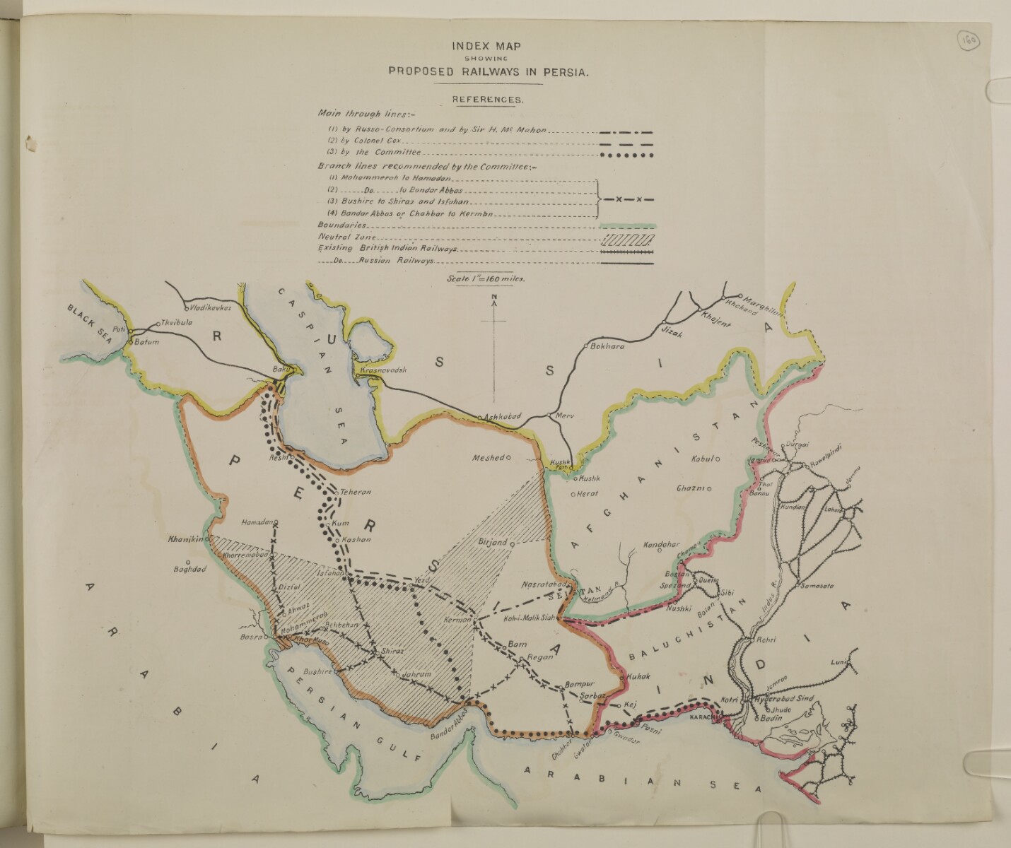
'INDEX MAP SHOWING PROPOSED RAILWAYS IN PERSIA.' [160r] (1/2)
The record is made up of 1 map. It was created in [1911]. It was written in English. The original is part of the British Library: India Office The department of the British Government to which the Government of India reported between 1858 and 1947. The successor to the Court of Directors. Records and Private Papers Documents collected in a private capacity. .
About this item
- Content
The map shows Persia, Afghanistan and parts of Russia, India and Arabia. The borders of these entities are outlined in watercolour paint of different colours (Persia, brown; Afghanistan, green; Russia, yellow; India, red; Arabia, green) and a reference key is given to the symbols used in the map. The map was intended to illustrate the proposed routes of railway lines in Persia to connect the railway system of Europe with the railway system of India.
- Extent and format
- 1 map
- Area map covers
- Map loading...
- Scale
- Scale 1:10,140,000
- Scale designator
- Horizontal
- Orientation
- North
- Degree coordinates
- Top-left: 43° 1' 34.32" N, 39° 20' 18.6" E
Top-right: 43° 1' 34.32" N, 75° 19' 20.28" E
Bottom-left: 22° 17' 45.6" N, 39° 20' 18.6" E
Bottom-right: 22° 17' 45.6" N, 75° 19' 20.28" E - Physical characteristics
Materials: printed on paper with manuscript additions in watercolour.
Dimensions: 340 mm x 390 mm
- Written in
- English in Latin script View the complete information for this record
Use and share this item
- Share this item
'INDEX MAP SHOWING PROPOSED RAILWAYS IN PERSIA.' [160r] (1/2), British Library: India Office Records and Private Papers, IOR/L/PS/10/307, f 160, in Qatar Digital Library <https://www.qdl.qa/archive/81055/vdc_100036625671.0x00007d> [accessed 5 July 2026]
https://www.qdl.qa/en/archive/81055/vdc_100036625671.0x00007d
Copy and paste the code below into your web page where you would like to embed the image.
<meta charset="utf-8"><a href="https://www.qdl.qa/en/archive/81055/vdc_100036625671.0x00007d">'INDEX MAP SHOWING PROPOSED RAILWAYS IN PERSIA.' [‎160r] (1/2)</a> <a href="https://www.qdl.qa/en/archive/81055/vdc_100036625671.0x00007d"> <img src="https://iiif.qdl.qa/iiif/images/81055/vdc_100000000419.0x0000c7/IOR_L_PS_10_307_0325.jp2/full/!280,240/0/default.jpg" alt="" /> </a>
This record has a IIIF manifest available as follows. If you have a compatible viewer you can drag the icon to load it.https://www.qdl.qa/en/iiif/81055/vdc_100000000419.0x0000c7/manifestOpen in Universal viewerOpen in Mirador viewerMore options for embedding images
Copyright: How to use this content
- Reference
- IOR/L/PS/10/307, f 160
- Title
- 'INDEX MAP SHOWING PROPOSED RAILWAYS IN PERSIA.'
- Pages
- 160r:160v
- Author
- East India Company, the Board of Control, the India Office, or other British Government Department
- Usage terms
- Open Government Licence