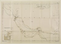
'GENERAL OUTLINE MAP OF THE PERSIAN GULF Showing Submarine Cables and the Principal Places mentioned in the Report.'
IOR/L/PS/20/64, f 55
2 items in this record
Search within this record
The record is made up of 1 map. It was created in 1903. It was written in English. The original is part of the British Library: India Office The department of the British Government to which the Government of India reported between 1858 and 1947. The successor to the Court of Directors. Records and Private Papers Documents collected in a private capacity. .
About this record
- Content
The map shows parts of the Arabian Peninsula, Persia, Afghanistan and Baluchistan, indicating major settlements and the routes of named submarine cables in the Persian Gulf The historical term used to describe the body of water between the Arabian Peninsula and Iran. , the Gulf of Oman and the Arabian Sea. The map also indicates hydrology and frontier lines.
An inset A small map or other image enclosed within the margin of a larger map, map sheet, or larger image; or papers placed inside a book or archival volume. map drawn at a scale of approximately 1:66,000 is entitled, 'Musandim Promontory. (Enlarged)'.
The map is Map 1 in ' Persian Gulf The historical term used to describe the body of water between the Arabian Peninsula and Iran. and Gulf of Oman' (Naval Intelligence Department No. 694), 1903. A printing statement reads, 'Weller & Graham Ltd. Litho, London.'.
- Extent and format
- 1 map
- Area map covers
- Map loading...
- Scale
- Scale not given
- Scale designator
- Horizontal
- Orientation
- North
- Degree coordinates
- Top-left: 34° 0' 0" N, 44° 0' 0" E
Top-right: 34° 0' 0" N, 63° 0' 0" E
Bottom-left: 23° 0' 0" N, 44° 0' 0" E
Bottom-right: 23° 0' 0" N, 63° 0' 0" E - It is part of
- 120 imagesRef: IOR/L/PS/20/64
- Physical characteristics
Materials: Printed in colour on paper
Dimensions: 456 x 703mm, on sheet 527 x 753mm
- Written in
- English in Latin script
- Type
- Map
Archive information for this record
- Original held at
- British Library: India Office The department of the British Government to which the Government of India reported between 1858 and 1947. The successor to the Court of Directors. Records and Private Papers Documents collected in a private capacity.
- Access conditions
Unrestricted
- Archive reference
- IOR/L/PS/20/64, f 55
- Date(s)
- 1903 (CE, Gregorian)
Access & Reference
History of this record
Related search terms
- Places
- Arabian Sea
Use and share this record
- Share this record
- Cite this record in your research
'GENERAL OUTLINE MAP OF THE PERSIAN GULF Showing Submarine Cables and the Principal Places mentioned in the Report.', British Library: India Office Records and Private Papers, IOR/L/PS/20/64, f 55, in Qatar Digital Library <https://www.qdl.qa/archive/81055/vdc_100036633865.0x000002> [accessed 3 July 2026]
- Link to this record
https://www.qdl.qa/en/archive/81055/vdc_100036633865.0x000002
- IIIF details
This record has a IIIF manifest available as follows. If you have a compatible viewer you can drag the icon to load it.https://www.qdl.qa/en/iiif/81055/vdc_100000000912.0x000005/manifestOpen in Universal viewerOpen in Mirador viewerMore options for embedding images
Copyright: How to use this content
- Reference
- IOR/L/PS/20/64, f 55
- Title
- 'GENERAL OUTLINE MAP OF THE PERSIAN GULF Showing Submarine Cables and the Principal Places mentioned in the Report.'
- Pages
- 55r:55v
- Author
- Admiralty, Naval Intelligence Department
- Usage terms
- Public Domain