![Tracing of Qatar Peninsula showing amended Coastline [‎7r] (1/2)](https://iiif.qdl.qa/iiif/images/81055/vdc_100000000555.0x0001ee/IOR_L_PS_12_1956_0016.jp2/full/!1200,1200/0/default.jpg "Tracing of Qatar Peninsula showing amended Coastline [‎7r] (1/2)")
Tracing of Qatar Peninsula showing amended Coastline [7r] (1/2)
The record is made up of 1 map. It was created in May-Jun 1934. It was written in English. The original is part of the British Library: India Office The department of the British Government to which the Government of India reported between 1858 and 1947. The successor to the Court of Directors. Records and Private Papers Documents collected in a private capacity. .
About this item
- Content
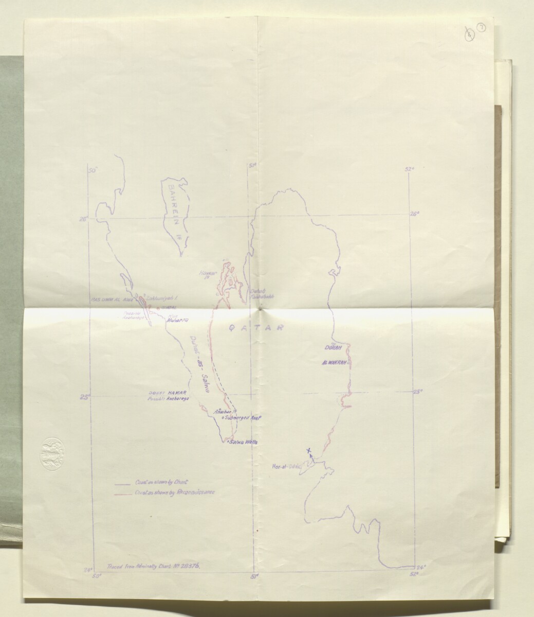
The map consists of a tracing from Admiralty Chart No. 28376 of the Qatar Peninsula and neighbouring Bahrain. The map outlines the coast as shown on the original chart (in blue), and an amended coastline (in red) as shown by a Royal Air Force reconnaissance on 9 May 1934.
- Extent and format
- 1 map
- Area map covers
- Map loading...
- Scale
- Scale not given
- Scale designator
- Horizontal
- Orientation
- North
- Degree coordinates
- Top-left: 26° 20' 37.98" N, 50° 0' 0.55" E
Top-right: 26° 20' 37.98" N, 52° 0' 3.74" E
Bottom-left: 24° 0' 0.19" N, 50° 0' 0.55" E
Bottom-right: 24° 0' 0.19" N, 52° 0' 3.74" E - Physical characteristics
Materials: 1 paper folio
Dimensions: 275mm x 223mm
- Written in
- English in Latin script View the complete information for this record
Use and share this item
- Share this item
Tracing of Qatar Peninsula showing amended Coastline [7r] (1/2), British Library: India Office Records and Private Papers, IOR/L/PS/12/1956, f 7, in Qatar Digital Library <https://www.qdl.qa/archive/81055/vdc_100040867672.0x00000f> [accessed 18 June 2026]
https://www.qdl.qa/en/archive/81055/vdc_100040867672.0x00000f
Copy and paste the code below into your web page where you would like to embed the image.
<meta charset="utf-8"><a href="https://www.qdl.qa/en/archive/81055/vdc_100040867672.0x00000f">Tracing of Qatar Peninsula showing amended Coastline [‎7r] (1/2)</a> <a href="https://www.qdl.qa/en/archive/81055/vdc_100040867672.0x00000f"> <img src="https://iiif.qdl.qa/iiif/images/81055/vdc_100000000555.0x0001ee/IOR_L_PS_12_1956_0016.jp2/full/!280,240/0/default.jpg" alt="" /> </a>
This record has a IIIF manifest available as follows. If you have a compatible viewer you can drag the icon to load it.https://www.qdl.qa/en/iiif/81055/vdc_100000000555.0x0001ee/manifestOpen in Universal viewerOpen in Mirador viewerMore options for embedding images
Copyright: How to use this content
- Reference
- IOR/L/PS/12/1956, f 7
- Title
- Tracing of Qatar Peninsula showing amended Coastline
- Pages
- 7r
- Author
- Admiralty
- Usage terms
- Public Domain