![‘North-western trans-frontier’ [‎242r] (1/2)](https://iiif.qdl.qa/iiif/images/81055/vdc_100000000602.0x0003d3/IOR_L_PS_12_3425A_0496.jp2/full/!1200,1200/0/default.jpg "‘North-western trans-frontier’ [‎242r] (1/2)")
‘North-western trans-frontier’ [242r] (1/2)
The record is made up of 1 map. It was created in 1902-1904. It was written in English. The original is part of the British Library: India Office The department of the British Government to which the Government of India reported between 1858 and 1947. The successor to the Court of Directors. Records and Private Papers Documents collected in a private capacity. .
About this item
- Content
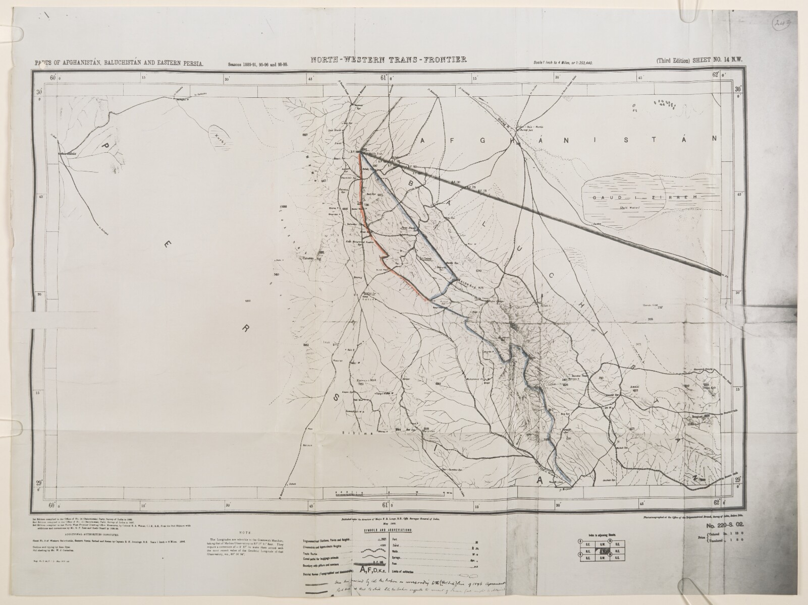
Copy of a map, referred to in an accompanying a letter written by Colonel Arthur Henry McMahon, British Commissioner, Seistan [Sīstān] Arbitration Commission, dated 5 November 1904 (ff 236-241). The letter refers to the boundary between Persia [Iran] and Baluchistan [in present-day Pakistan] around Mirjawa [Mīrjāveh], as established in an agreement of 1896.
The map indicates: hydrology; topography, with some indication of relief; trigonometrical stations, with heights indicated in feet; settlements; trade routes. The frontier lines discussed in McMahon’s letter are marked in blue and red pencil.
The original map was published under the direction of Major Francis Becon Longe, Officiating Surveyor General of India, in May 1902.
- Extent and format
- 1 map
- Area map covers
- Map loading...
- Scale
- 1:292,608
- Scale designator
- Horizontal
- Orientation
- North
- Degree coordinates
- Top-left: 30° 0' 51.84" N, 60° 0' 46.08" E
Top-right: 30° 0' 51.84" N, 62° 0' 44.28" E
Bottom-left: 29° 0' 20.52" N, 60° 0' 46.08" E
Bottom-right: 29° 0' 20.52" N, 62° 0' 44.28" E - Physical characteristics
Dimensions: 310 x 495 mm, on sheet 410 x 550 mm.
Materials: Photocopy on paper, with pencil additions.
- Written in
- English in Latin script View the complete information for this record
Use and share this item
- Share this item
‘North-western trans-frontier’ [242r] (1/2), British Library: India Office Records and Private Papers, IOR/L/PS/12/3425A, f 242, in Qatar Digital Library <https://www.qdl.qa/archive/81055/vdc_100042214845.0x000054> [accessed 4 May 2024]
https://www.qdl.qa/en/archive/81055/vdc_100042214845.0x000054
Copy and paste the code below into your web page where you would like to embed the image.
<meta charset="utf-8"><a href="https://www.qdl.qa/en/archive/81055/vdc_100042214845.0x000054">‘North-western trans-frontier’ [‎242r] (1/2)</a> <a href="https://www.qdl.qa/en/archive/81055/vdc_100042214845.0x000054"> <img src="https://iiif.qdl.qa/iiif/images/81055/vdc_100000000602.0x0003d3/IOR_L_PS_12_3425A_0496.jp2/full/!280,240/0/default.jpg" alt="" /> </a>
This record has a IIIF manifest available as follows. If you have a compatible viewer you can drag the icon to load it.https://www.qdl.qa/en/iiif/81055/vdc_100000000602.0x0003d3/manifestOpen in Universal viewerOpen in Mirador viewerMore options for embedding images
Copyright: How to use this content
- Reference
- IOR/L/PS/12/3425A, f 242
- Title
- ‘North-western trans-frontier’
- Pages
- 242r:242v
- Author
- East India Company, the Board of Control, the India Office, or other British Government Department
- Usage terms
- Open Government Licence