![Coll 6/88 'Intelligence: Military Report on Arabia (C.B. 1892).' [‎39r] (82/133)](https://iiif.qdl.qa/iiif/images/81055/vdc_100000000555.0x0002bb/IOR_L_PS_12_2160B_0084.jp2/full/!1200,1200/0/default.jpg "Coll 6/88 'Intelligence: Military Report on Arabia (C.B. 1892).' [‎39r] (82/133)")
Coll 6/88 'Intelligence: Military Report on Arabia (C.B. 1892).' [39r] (82/133)
The record is made up of 1 file (63 folios). It was created in Feb 1932-7 Feb 1942. It was written in English. The original is part of the British Library: India Office The department of the British Government to which the Government of India reported between 1858 and 1947. The successor to the Court of Directors. Records and Private Papers Documents collected in a private capacity. .
Transcription
This transcription is created automatically. It may contain errors.
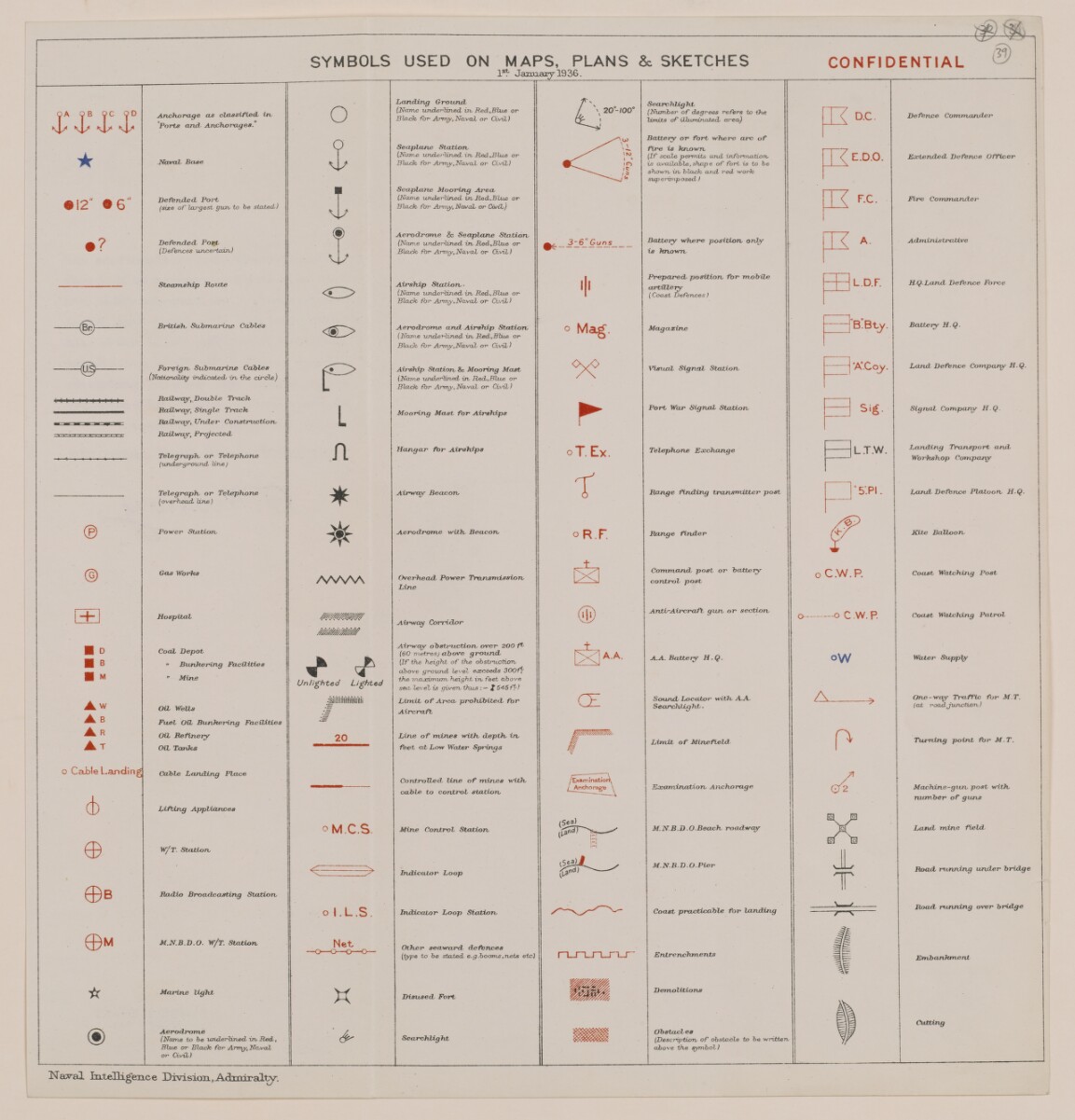
Ifiese SyrnboLs used, otl Maps, Plans and,
Shetchesha\nng been approved by My Lords
Commissioners of the Admiralty, will be used
in all maps and plans issued with. Naval
Inieliicjence Reports. They should- also be used
whenever possible in the Naval service.Having
been co-ordinated with accepted symbols in
other services .they will be found, particularly
suitably for combined operations
BY COMMAND OF THEIR LORDSHIPS
CJ^, /fyyU/VYa^
SYMBOLS CHART
JANUARY 1936
SYMBOLS USED ON MAPS, PLANS & SKETCHES
1 st " JazL-uarjr 1936.
CONFIDENTIAL
OA OB OC OD
>4/ ’vjo*
★
® 12" O 6 '
a?
©
©
L±J
■ D
■ B
■ M
A w
A b
A R
At
o Ca£>!e Landing
6
©
©B
© M
AnchorxLge cls classtfled, in
"Ports and Anchorages.
Neural, Base
Defended Port
(size of largest gwv to be stated)
Defended, Port
(Defences uncertain)
Steamship Horde
British, Submarine Cables
Foreign, Submarine Cables
(NcdandWy indicated, in, Che circle)
Railway, Double Track
Railway, Single Track
Railway, Under Construction,
Railway, Projected,
Telegraplt or Telephone
(underground doe)
Telegraph, or Telephone
(overhead 'line)
Power Station
Gas Works
Hospital
Coal Depot
* Bunkering Facilities
" Mine
Oil Wells
Fuel Oil Bunkering Facilities
Oil Refinery
Oil Tanks
Cable Landing Place
Lifting Appluvrvces
o
o
©
<o
P
L
A
*
¥
/VWSA
W/T. Station
Radio Broadcasting Station
M.N.B.D.O. W/T. Station
Marine light
Aerodrome
(Name to be underlined in Red,,
Blue or Black for Army, Naval
or Civil)
Untighted lighted
20
oM.C.S.
<E
X
Landing Ground,
(Name ximderlined in, RedJBlue or
Black for Amy,Naval or Civil)
Seaplane Station
(Name underlined in. Red,,Blue or
Black for Amy, Naval or Civil)
Seaplane Mooring Area
(Name underlined in, Red.Blue or
Black for Army, Naval or Civil)
Aerodrome & Seaplane Station
(Name underlined in, Redjilue or
Black for Amy,Naval or Civil)
Airship Station-
(Name underlined in, Red.Blue or
Black for Army,Naval or Civil)
Aerodrome and Airship Station
(Name underlined in. Red,Blue or
Black for Army,Naval or Civil)
Airship Station & Mooring Mast
(Name underlined in, Red.Blue or
Black for Arm}', Naval or Civil)
Mooring Mast for Airships
Hangar for Airships
Airway Beacon
Aerodrome with. Beacon
Overhead, Power Transmission
Line
Airway Corridor
Airway obstruction over 200 U
(60 metres) above ground,
(If the height of the obstruction,
above ground level exceeds SOOff’
the maximum, height in, feet above
sea level is given, thus : — X 545 fp)
Limit of Area prolvibiteil for
Aircraft
Line of mines with, depth, in
feet at Low Water Spiings
Controlled, line of mines with,
cable, to control station
Mine Control Station
Indicator Loop
Indicator Loop Station
Other seaward defences
(type to be stated e.g.booms.nets etc)
Disused Fort
20 -/ 00 “
Searchlig ht
3~6"Guns
i !
> Mag.
r
jT. Ex.
T
oR.F.
F© i a A
L©Sj ■ •
(X
/Examinatii©
/ A nchorage \
Searchlight
(Number of degrees refers to the
limits of illuminated, area,)
Battery or fort where arc of
fire is known
(If scale permits and information,
is available, shop e of fort is to be
shown, in, black and red work
sup erimp osed)
Battery where position only
is known
Prepared, position for mobile
artillery
(Coast Defences)
Magazine
A D ' C
T E.D.O.
7 F.C.
I A -
Visual Signal Station
Port War Signal Station
Telephone Exchange
Range finding transmitter post
Range finder
Command, post or battery
control post
Anti-Aircraft gun or section
A.A. Battery H.Q.
Sound, Locator with, A.A..
Searchlight ■
Limit of Minefield
Exartiination Anchorage
M.N.B.D.O.Beach, roadway
M.N.B.D.O.Pier
Coast practicable for landing
Entrenchments
Demolitions
Obstacles
(Descrifition, of obstacle to be written,
above the symbol)
L.D.F.
B.Bty.
’A’.Coy.
L.T.W.
Tsai.
Defence Commander
Extended, Defence Officer
Fire Commander
Administrative
HQ Land, Defence Force
oC.W.P.
o o C W. P.
oW
A,
P
©2
X
T
jb—✓_
r v
Battery H. Q ■
Land Defence Company H.Q.
Signal Company H.Q
Landing Transport and.
Workshop Company
Land, Defence Platoon H.Q.
Kite Balloon
Coast Watching Post
Coast Watching Patrol
Water Supply
One-way Traffic for M.T.
(at roadJuMctCon)
Turning point for M. T.
Machine-gun post with,
number of guns
Land, mine field.
Road, running under bridge
Road, running over bridge
Embankment
Cutting
Naval IrLtelHgence Division,AAmiralty - .
About this item
- Content
This file consists of two parts. The first part (folios 1-9) begins with a 'state of report' document for an Admiralty Naval Intelligence Division report entitled 'Arabia, Intelligence Report'; the 'state report' concerns the updating of the report in October 1941, and it includes a list of maps, plans and photographs that are contained in the report. There then follows a small amount of correspondence between India Office The department of the British Government to which the Government of India reported between 1858 and 1947. The successor to the Court of Directors. , War Office, and General Staff (India) officials regarding the supply of an earlier issue of the report, dated 1939.
The second part of the file consists of the actual report, entitled 'C.B. 1892 (X) (10/41) Arabia Intelligence Report', dated October 1941, with appended maps, plans and photographs relating to Arabian Peninsula ports. The report is divided into four sections (six sections are listed in the table of contents, which lists sections one and three, most of section two, and one part of section five, as 'not issued', i.e. not printed in this edition of the report).
The first section to appear in the report is entitled 'Section II: Strategy and Tactics'; parts 1 and 3-6 of this section have been omitted, leaving part 2, which has the heading 'Possible Lines on which War Plans would be Framed'.
The next section, 'Section IV: Geography and Topography', provides an overview of the geography and topography of the Arabian Peninsula, including information about climate, transport facilities (including a table of landing grounds and seaplane anchorages), and communications.
The third section, 'Section V: Base Facilities and Maintenance of the Fleet' (from which part one has been omitted), provides a summary of principal commercial dockyards and repair bases, locations for fuel storage, supplies and storage of ammunition, fixed coastal defences, and aircraft.
The final section of the report, 'Section VI: Ports, Anchorages and Their Defences', proceeds through a number of Gulf ports in alphabetical order (i.e. Akaba, Bahrain, Doha, Hodeida and Ras Kethib, Jedda, Kamaran, Kuwait, Mukalla, and Muscat), describing each place's port facilities, anchorages and defences, as well as providing other information relating to matters such as government, commerce, water supply, transport and communications.
Enclosed with the maps and plans is a symbols chart, which lists some of the symbols used in the maps and plans.
- Extent and format
- 1 file (63 folios)
- Arrangement
The Arabia Intelligence Report contains a table of contents. The maps, plans and photographs, which are listed below the table of contents, appear after the main text of the report.
- Physical characteristics
Foliation: The file is formed of two parts. The foliation sequence (used for referencing) commences at the front cover of the first part at 1 and terminates at the inside back cover of the second part at 65; these numbers are written in pencil, are circled, and are located in the top right corner of the recto The front of a sheet of paper or leaf, often abbreviated to 'r'. side of each folio.
- Written in
- English in Latin script View the complete information for this record
Use and share this item
- Share this item
Coll 6/88 'Intelligence: Military Report on Arabia (C.B. 1892).' [39r] (82/133), British Library: India Office Records and Private Papers, IOR/L/PS/12/2160B, in Qatar Digital Library <https://www.qdl.qa/archive/81055/vdc_100043097172.0x000053> [accessed 20 July 2026]
https://www.qdl.qa/en/archive/81055/vdc_100043097172.0x000053
Copy and paste the code below into your web page where you would like to embed the image.
<meta charset="utf-8"><a href="https://www.qdl.qa/en/archive/81055/vdc_100043097172.0x000053">Coll 6/88 'Intelligence: Military Report on Arabia (C.B. 1892).' [‎39r] (82/133)</a> <a href="https://www.qdl.qa/en/archive/81055/vdc_100043097172.0x000053"> <img src="https://iiif.qdl.qa/iiif/images/81055/vdc_100000000555.0x0002bb/IOR_L_PS_12_2160B_0084.jp2/full/!280,240/0/default.jpg" alt="" /> </a>
This record has a IIIF manifest available as follows. If you have a compatible viewer you can drag the icon to load it.https://www.qdl.qa/en/iiif/81055/vdc_100000000555.0x0002bb/manifestOpen in Universal viewerOpen in Mirador viewerMore options for embedding images
Copyright: How to use this content
- Reference
- IOR/L/PS/12/2160B
- Title
- Coll 6/88 'Intelligence: Military Report on Arabia (C.B. 1892).'
- Pages
- front, front-i, 2r:9v, front-a, back, spine, edge, head, tail, front-a-i, 11r:39v
- Author
- East India Company, the Board of Control, the India Office, or other British Government Department
- Usage terms
- Open Government Licence