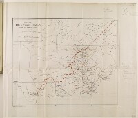
'Map showing TRIBES AND NEW BOUNDARY OF THE ADEN PROTECTORATE'
IOR/L/PS/12/2068, f 382
2 items in this record
Search within this record
The record is made up of 1 map. It was created in Jan 1906. It was written in English. The original is part of the British Library: India Office The department of the British Government to which the Government of India reported between 1858 and 1947. The successor to the Court of Directors. Records and Private Papers Documents collected in a private capacity. .
About this record
- Content
The map shows parts of southern Yemen, including the Aden Protectorate. The map, which was produced by the War Office, includes lines drawn both in red ink and in yellow and blue crayon. According to notes written in pencil, the blue line depicts the '[r]ough boundary of Imam's [Yaḥyá Muḥammad Ḥamīd al-Dīn's] present encroachments', the yellow line shows the Imam's proposed boundary, and the red line illustrates the boundary proposed by the Assistant Political Resident A senior ranking political representative (equivalent to a Consul General) from the diplomatic corps of the Government of India or one of its subordinate provincial governments, in charge of a Political Residency. at Aden, Major Trenchard Craven William Fowle.
- Extent and format
- 1 map
- Area map covers
- Map loading...
- Scale
- 1:633,600
- Scale designator
- Horizontal
- Orientation
- North
- Degree coordinates
- Top-left: 14° 1' 9.68" N, 43° 0' 1.76" E
Top-right: 14° 1' 9.68" N, 45° 29' 47.2" E
Bottom-left: 12° 33' 40.56" N, 43° 0' 1.76" E
Bottom-right: 12° 33' 40.56" N, 45° 29' 47.2" E - It is part of
- 782 imagesRef: IOR/L/PS/12/2068
- Physical characteristics
Materials: Printed on paper.
Dimensions: 408 x 494mm, on sheet 532 x 605mm.
- Written in
- English in Latin script
- Type
- Map
Archive information for this record
- Original held at
- British Library: India Office The department of the British Government to which the Government of India reported between 1858 and 1947. The successor to the Court of Directors. Records and Private Papers Documents collected in a private capacity.
- Access conditions
Unrestricted
- Archive reference
- IOR/L/PS/12/2068, f 382
- Date(s)
- Jan 1906 (CE, Gregorian)
Access & Reference
History of this record
Use and share this record
- Share this record
- Cite this record in your research
'Map showing TRIBES AND NEW BOUNDARY OF THE ADEN PROTECTORATE', British Library: India Office Records and Private Papers, IOR/L/PS/12/2068, f 382, in Qatar Digital Library <https://www.qdl.qa/archive/81055/vdc_100044802046.0x000004> [accessed 4 June 2026]
- Link to this record
https://www.qdl.qa/en/archive/81055/vdc_100044802046.0x000004
- IIIF details
This record has a IIIF manifest available as follows. If you have a compatible viewer you can drag the icon to load it.https://www.qdl.qa/en/iiif/81055/vdc_100000000555.0x00025e/manifestOpen in Universal viewerOpen in Mirador viewerMore options for embedding images
Copyright: How to use this content
- Reference
- IOR/L/PS/12/2068, f 382
- Title
- 'Map showing TRIBES AND NEW BOUNDARY OF THE ADEN PROTECTORATE'
- Pages
- 382r:382v
- Author
- East India Company, the Board of Control, the India Office, or other British Government Department
- Usage terms
- Open Government Licence