'ANNEXE C: MAP OF PART OF ARABIA'
IOR/L/PS/12/2131, f 65

2 items in this record
Search within this record
The record is made up of 1 map. It was created in Feb 1914. It was written in English. The original is part of the British Library: India Office The department of the British Government to which the Government of India reported between 1858 and 1947. The successor to the Court of Directors. Records and Private Papers Documents collected in a private capacity. .
About this record
- Content
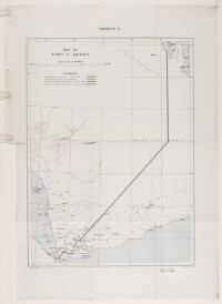
Map of the south-western part of the Arabian Peninsula, enclosed in a printed copy of the Anglo-Ottoman Convention of 1914. It depicts coloured boundaries as laid down in the Convention. A key is included in the upper left-hand corner. In addition to boundaries the map indicates hydrology and settlements.
Printed by the War Office, February 1914. The map also states the names of the British and Ottoman signatories of the Anglo-Ottoman Convention: E Grey [Edward Grey, Secretary of State for Foreign Affairs] and I Hakky [Ibrahim Hakki Pasha An Ottoman title used after the names of certain provincial governors, high-ranking officials and military commanders. , Ottoman representative].
- Extent and format
- 1 map
- Area map covers
- Map loading...
- Scale
- Scale approximately 1:3,000,000
- Scale designator
- Horizontal
- Orientation
- North
- Degree coordinates
- Top-left: 26° 15' 36" N, 41° 27' 0" E
Top-right: 26° 15' 36" N, 51° 58' 48" E
Bottom-left: 12° 14' 24" N, 41° 27' 0" E
Bottom-right: 12° 14' 24" N, 51° 58' 48" E - It is part of
- 183 imagesRef: IOR/L/PS/12/2131
- Physical characteristics
Materials: Printed on paper.
Dimensions: 496 x 360 mm, on sheet 663 x 445 mm.
- Written in
- English in Latin script
- Type
- Map
Archive information for this record
- Original held at
- British Library: India Office The department of the British Government to which the Government of India reported between 1858 and 1947. The successor to the Court of Directors. Records and Private Papers Documents collected in a private capacity.
- Access conditions
Unrestricted
- Archive reference
- IOR/L/PS/12/2131, f 65
- Date(s)
- Feb 1914 (CE, Gregorian)
Access & Reference
History of this record
Use and share this record
- Share this record
- Cite this record in your research
'ANNEXE C: MAP OF PART OF ARABIA', British Library: India Office Records and Private Papers, IOR/L/PS/12/2131, f 65, in Qatar Digital Library <https://www.qdl.qa/archive/81055/vdc_100045009574.0x000003> [accessed 27 July 2026]
- Link to this record
https://www.qdl.qa/en/archive/81055/vdc_100045009574.0x000003
- IIIF details
This record has a IIIF manifest available as follows. If you have a compatible viewer you can drag the icon to load it.https://www.qdl.qa/en/iiif/81055/vdc_100000000555.0x00029d/manifestOpen in Universal viewerOpen in Mirador viewerMore options for embedding images
Copyright: How to use this content
- Reference
- IOR/L/PS/12/2131, f 65
- Title
- 'ANNEXE C: MAP OF PART OF ARABIA'
- Pages
- 65r:65v
- Author
- East India Company, the Board of Control, the India Office, or other British Government Department
- Usage terms
- Open Government Licence