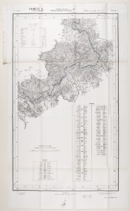
'ANNEXE B. SOUTH ARABIA ANGLO-TURKISH BOUNDARY. SHEET NO. 3'
IOR/L/PS/12/2131, f 63
2 items in this record
Search within this record
The record is made up of 1 map on 4 sheets. It was created in 1914. It was written in English and Arabic. The original is part of the British Library: India Office The department of the British Government to which the Government of India reported between 1858 and 1947. The successor to the Court of Directors. Records and Private Papers Documents collected in a private capacity. .
About this record
- Content
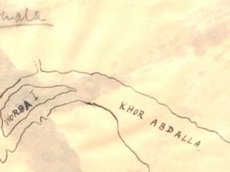
This map is enclosed in a printed copy of the Anglo-Ottoman Convention of 1914. It depicts the line of demarcation of the boundary determined to separate the Yemen from the territory of the nine cantons of Aden (shown in blue).
The map's borders are lettered and numbered and are used to reference places in an accompanying table. Areas on the map are marked with Roman numerals and are listed in a second table of references. A third table provides a key to symbols and abbreviations. Place names and symbol and abbreviation references are printed in English and Arabic. The map also indicates hydrology, settlements, cultivation and roads. Relief is shown by contours and spot heights.
This map is sheet three of four. Also included is an index to adjoining sheets and a note on the survey's sources.
Small printed text near below the map states that it was surveyed by the Anglo-Turkish Boundary Commission, under Colonel Robert Alexander Wahab and Colonel Mustapha Remzi Bey, and heliozincographed at the Survey of India Offices, Calcutta. The map also states the names of the British and Ottoman signatories of the Anglo-Ottoman Convention: E Grey [Edward Grey, Secretary of State for Foreign Affairs] and I Hakky [Ibrahim Hakki Pasha An Ottoman title used after the names of certain provincial governors, high-ranking officials and military commanders. , Ottoman representative].
- Extent and format
- 1 map on 4 sheets
- Area map covers
- Map loading...
- Scale
- 1:126,720
- Scale designator
- Horizontal
- Orientation
- North
- Degree coordinates
- Top-left: 13° 50' 33.26" N, 44° 0' 2.22" E
Top-right: 13° 50' 33.26" N, 44° 31' 36.22" E
Bottom-left: 13° 30' 40.26" N, 44° 0' 2.22" E
Bottom-right: 13° 30' 40.26" N, 44° 31' 36.22" E - It is part of
- 183 imagesRef: IOR/L/PS/12/2131
- Physical characteristics
Materials: Printed on paper.
Dimensions: 936 x 560mm, on sheet 1081 x 633mm.
- Written in
- English and Arabic in Latin and Arabic script
- Type
- Map
Archive information for this record
- Original held at
- British Library: India Office The department of the British Government to which the Government of India reported between 1858 and 1947. The successor to the Court of Directors. Records and Private Papers Documents collected in a private capacity.
- Access conditions
Unrestricted
- Archive reference
- IOR/L/PS/12/2131, f 63
- Date(s)
- 1914 (CE, Gregorian)
Access & Reference
History of this record
Related search terms
- Places
- YemenAden Protectorate
Use and share this record
- Share this record
- Cite this record in your research
'ANNEXE B. SOUTH ARABIA ANGLO-TURKISH BOUNDARY. SHEET NO. 3', British Library: India Office Records and Private Papers, IOR/L/PS/12/2131, f 63, in Qatar Digital Library <https://www.qdl.qa/archive/81055/vdc_100045009574.0x000005> [accessed 26 April 2024]
- Link to this record
https://www.qdl.qa/en/archive/81055/vdc_100045009574.0x000005
- IIIF details
This record has a IIIF manifest available as follows. If you have a compatible viewer you can drag the icon to load it.https://www.qdl.qa/en/iiif/81055/vdc_100000000555.0x00029d/manifestOpen in Universal viewerOpen in Mirador viewerMore options for embedding images
Copyright: How to use this content
- Reference
- IOR/L/PS/12/2131, f 63
- Title
- 'ANNEXE B. SOUTH ARABIA ANGLO-TURKISH BOUNDARY. SHEET NO. 3'
- Pages
- 63r:63v
- Author
- East India Company, the Board of Control, the India Office, or other British Government Department
- Usage terms
- Open Government Licence