!['MAP 9. TO ILLUSTRATE THE BATTLE OF CTESIPHON.' [‎316r] (1/2)](https://iiif.qdl.qa/iiif/images/81055/vdc_100025551852.0x000001/IOR_L_MIL_17_15_66_2_0641.jp2/full/!1200,1200/0/default.jpg "'MAP 9. TO ILLUSTRATE THE BATTLE OF CTESIPHON.' [‎316r] (1/2)")
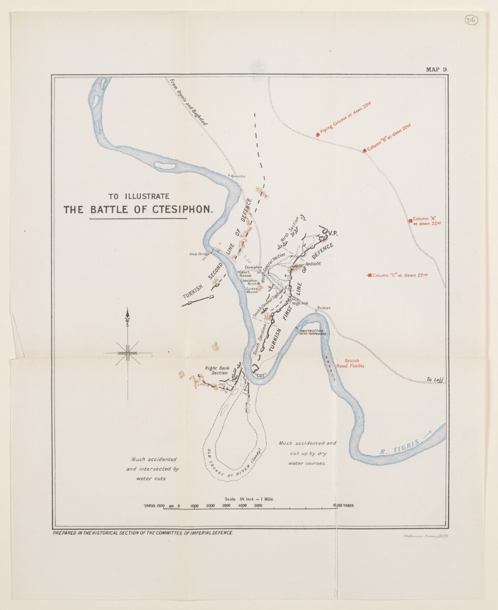
'MAP 9. TO ILLUSTRATE THE BATTLE OF CTESIPHON.' [316r] (1/2)
The record is made up of 1 map. It was created in 1923. It was written in English. The original is part of the British Library: India Office The department of the British Government to which the Government of India reported between 1858 and 1947. The successor to the Court of Directors. Records and Private Papers Documents collected in a private capacity. .
About this item
- Content
The map accompanies The Campaign in Mesopotamia 1914-1918. Volume II , and shows a region around Ctesiphon in central and eastern Iraq, indicating military operations, fortifications, settlements, roads and watercourses.
Prepared in the Historical Section of the Committee of Imperial Defence, and printed at the Ordnance Survey in 1923.
- Extent and format
- 1 map
- Area map covers
- Map loading...
- Scale
- Scale 1:84,480
- Scale designator
- Horizontal
- Orientation
- North
- Degree coordinates
- Top-left: 33° 11' 52.08" N, 44° 27' 49.32" E
Top-right: 33° 11' 52.08" N, 44° 41' 48.48" E
Bottom-left: 32° 58' 19.92" N, 44° 27' 49.32" E
Bottom-right: 32° 58' 19.92" N, 44° 41' 48.48" E - Physical characteristics
Materials: Printed in colour on paper
Dimensions: 275 x 240mm, on sheet 360 x 290mm
- Written in
- English in Latin script View the complete information for this record
Use and share this item
- Share this item
'MAP 9. TO ILLUSTRATE THE BATTLE OF CTESIPHON.' [316r] (1/2), British Library: India Office Records and Private Papers, IOR/L/MIL/17/15/66/2, f 316, in Qatar Digital Library <https://www.qdl.qa/archive/81055/vdc_100045738552.0x00002a> [accessed 17 July 2026]
https://www.qdl.qa/en/archive/81055/vdc_100045738552.0x00002a
Copy and paste the code below into your web page where you would like to embed the image.
<meta charset="utf-8"><a href="https://www.qdl.qa/en/archive/81055/vdc_100045738552.0x00002a">'MAP 9. TO ILLUSTRATE THE BATTLE OF CTESIPHON.' [‎316r] (1/2)</a> <a href="https://www.qdl.qa/en/archive/81055/vdc_100045738552.0x00002a"> <img src="https://iiif.qdl.qa/iiif/images/81055/vdc_100025551852.0x000001/IOR_L_MIL_17_15_66_2_0641.jp2/full/!280,240/0/default.jpg" alt="" /> </a>
This record has a IIIF manifest available as follows. If you have a compatible viewer you can drag the icon to load it.https://www.qdl.qa/en/iiif/81055/vdc_100025551852.0x000001/manifestOpen in Universal viewerOpen in Mirador viewerMore options for embedding images
Copyright: How to use this content
- Reference
- IOR/L/MIL/17/15/66/2, f 316
- Title
- 'MAP 9. TO ILLUSTRATE THE BATTLE OF CTESIPHON.'
- Pages
- 316r:316v
- Author
- East India Company, the Board of Control, the India Office, or other British Government Department
- Usage terms
- Open Government Licence