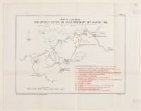
'MAP 17. MAP TO ILLUSTRATE THE ATTACK ON THE DUJAILA REDOUBT: 8TH. MARCH, 1916.'
IOR/L/MIL/17/15/66/2, f 322
2 items in this record
Search within this record
The record is made up of 1 map. It was created in 1924. It was written in English. The original is part of the British Library: India Office The department of the British Government to which the Government of India reported between 1858 and 1947. The successor to the Court of Directors. Records and Private Papers Documents collected in a private capacity. .
About this record
- Content
The map accompanies The Campaign in Mesopotamia 1914-1918. Volume II , and shows a region around the Dujaila watercourse [Nahr ad Dujaylah] in central and eastern Iraq, indicating military operations, towns, settlements, rivers and marshes. A key in the lower right corner explains numbered locations on the map.
Prepared in the Historical Section of the Committee of Imperial Defence, and printed at the Ordnance Survey in 1924.
- Extent and format
- 1 map
- Area map covers
- Map loading...
- Scale
- Scale approximately 1:190,000
- Scale designator
- Horizontal
- Orientation
- North
- Degree coordinates
- Top-left: 32° 44' 13.2" N, 45° 43' 10.56" E
Top-right: 32° 44' 13.2" N, 46° 19' 30.72" E
Bottom-left: 32° 22' 30" N, 45° 43' 10.56" E
Bottom-right: 32° 22' 30" N, 46° 19' 30.72" E - It is part of
- 660 imagesRef: IOR/L/MIL/17/15/66/2
- Physical characteristics
Materials: Printed in colour on paper
Dimensions: 230 x 325mm, on sheet 317 x 405mm
- Written in
- English in Latin script
- Type
- Map
Archive information for this record
- Original held at
- British Library: India Office The department of the British Government to which the Government of India reported between 1858 and 1947. The successor to the Court of Directors. Records and Private Papers Documents collected in a private capacity.
- Access conditions
Unrestricted
- Archive reference
- IOR/L/MIL/17/15/66/2, f 322
- Date(s)
- 1924 (CE, Gregorian)
Access & Reference
History of this record
Related search terms
- People & organisations
- Ordnance Survey, Southampton
Use and share this record
- Share this record
- Cite this record in your research
'MAP 17. MAP TO ILLUSTRATE THE ATTACK ON THE DUJAILA REDOUBT: 8TH. MARCH, 1916.', British Library: India Office Records and Private Papers, IOR/L/MIL/17/15/66/2, f 322, in Qatar Digital Library <https://www.qdl.qa/archive/81055/vdc_100045742391.0x00000d> [accessed 30 April 2024]
- Link to this record
https://www.qdl.qa/en/archive/81055/vdc_100045742391.0x00000d
- IIIF details
This record has a IIIF manifest available as follows. If you have a compatible viewer you can drag the icon to load it.https://www.qdl.qa/en/iiif/81055/vdc_100025551852.0x000001/manifestOpen in Universal viewerOpen in Mirador viewerMore options for embedding images
Copyright: How to use this content
- Reference
- IOR/L/MIL/17/15/66/2, f 322
- Title
- 'MAP 17. MAP TO ILLUSTRATE THE ATTACK ON THE DUJAILA REDOUBT: 8TH. MARCH, 1916.'
- Pages
- 322r:322v
- Author
- East India Company, the Board of Control, the India Office, or other British Government Department
- Usage terms
- Open Government Licence