![File 4648/1912 'Railway projects in South Persia; surveys of Gulf ports' [‎108v] (221/258)](https://iiif.qdl.qa/iiif/images/81055/vdc_100000000419.0x0000d0/IOR_L_PS_10_316_0227.jp2/full/!1200,1200/0/default.jpg "File 4648/1912 'Railway projects in South Persia; surveys of Gulf ports' [‎108v] (221/258)")
File 4648/1912 'Railway projects in South Persia; surveys of Gulf ports' [108v] (221/258)
The record is made up of 1 volume (129 folios). It was created in 1912-1916. It was written in English. The original is part of the British Library: India Office The department of the British Government to which the Government of India reported between 1858 and 1947. The successor to the Court of Directors. Records and Private Papers Documents collected in a private capacity. .
Transcription
This transcription is created automatically. It may contain errors.
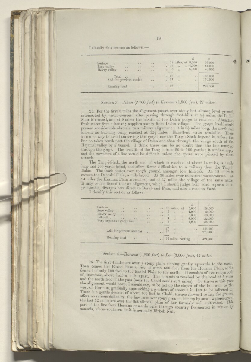
18
I classify this section as follows :—
Surface
£
12 miles, at 3,000
36.000 ^
Easy valley
16 „ „ 4,000
8 „ „ 6,000
64.000
Heavy valley
48,000
Total
36 „
148.000
Add for previous section
31 „
130,000
Running total .. • •
67 „
278,000
Section 3 .—Jihun {? 700 feet) to Hormuz (1,800 feet), 27 miles.
25. For the first 8 miles the alignment passes over stony but almost level ground
intersected by water-courses; after passing through foot-lulls at 8| miles, the Rud-i-
Shur is crossed, and at 9 miles the mouth of the Dalan gorge is reached. Abundant
fresh water from a kanat; supplies scanty from Dalan village. The gorge itself would
present considerable obstacle to a railway alignment: it is 3-| miles long, the north end
known as Sartang being reached at 12^ miles. Excellent water available. There
seems no way to avoid traversing this gorge, nor the Tang-i-Shak beyond it, unless the
line be taken south past the village of Dalan and then through the range south of the
Hajamal valley by a tunnel. I think there can be no doubt that the line must go
through the gorge. The breadth of the Tang is from 80 to 100 yards ; it winds sharply
and the curvature of a line would be difficult unless the spurs were pierced by short
tunnels.
The Tang-i-Shak, the north end of which is reached at about 14 miles, is 1 mile
long and 200 yards broad, and offers fewer difficulties to a railway than the Tang-i-
Dalan. The track passes over rough ground amongst low hillocks. At 19 miles it
crosses the Dehrahi Plain, a mile broad. At 30 miles over numerous watercourses. At
24 miles the Hurmuz Plain is reached, and at 27 miles the village of the same name.
It may be mentioned that an alignment, which I should judge from road reports to be
practicable, diverges here direct to Darab and Fasa, and also a road to Yazd.
I classify this section as follows :—
Surface ..
Easy valley
Heavy valley
Difficult..
Very expensive gorge line
Add for previous sections
Running total
£
£
12 miles, at 3,000
36,000
3 „ „ 4,000
12,000
5 „ „ 6,000
30,000
4 „ „ 8,000
32,000
3 „ „ 1,200
36,000
27 „
146,000
67 „
278,000
94 miles, costing
424,000
a .—nor muz feet)
(>. 1 lie fiist 4 miles are over a stony plain sloping gently upwards to the nort
dhen comes the Buzan Pass, a rise of some 600 feet from the Hormuz Plain, and
rescen o mi 3 eet to the Badini Plain to the north. It consists of two ridges bol
of limestone, about half a mile apart. The summit is reached by the road at 5 mil
ami the north foot of the pass (near the Chaki serai) at 7 miles). To traverse this pa
wit 'Pw ent W ° U d i haV u ’ 1 should “V’ to be led U P th e sl opes of the hill, well to tl
T] 01 ln “f’f' ai:,uall y, a PP roa ehing a gradient of about 1 in 100 to be adhered t
oil, S no t T A-K^n 0 , ab , 0Ut 100 feet t0 Chaki - thence forward to Lar the groui
the lost 1 9 T' * CU | runs ever stony ground, but up by small watercourse
mrt of t, h V 1 ™ th6 flat alluvial P lain Lar > formerly well cultivated. Tb
nomads who^c onwa rds runs through country frequented in winter 1
nomads, whose southern limit is normally Birkeh Nuh. J 1
About this item
- Content
The volume comprises telegrams, despatches, correspondence, memoranda, notes, and maps relating to the development of railways projects in South Persia and the associated marine surveys of Gulf ports, notably Bandar Abbas and Bushire.
The volume includes the report of Lieutenant Arnold Talbot Wilson on the technical issues concerning development of railway lines between Bushire and Shiraz, and Bandar Abbas and Shiraz. Also included is a report on the commercial possibilities of these two developments, compiled by Commercial Adviser, H G Chick. These reports (folios 101-124) are preceded by an accompanying summary and analysis by the Political Resident A senior ranking political representative (equivalent to a Consul General) from the diplomatic corps of the Government of India or one of its subordinate provincial governments, in charge of a Political Residency. in the Persian Gulf The historical term used to describe the body of water between the Arabian Peninsula and Iran. , Percy Zachariah Cox.
Also discussed in the correspondence is the question of concessions for railways in the neutral zone and the relative advantages (climate, water supply) of Bushire and Bandar Abbas as railway termini in the Persian Gulf The historical term used to describe the body of water between the Arabian Peninsula and Iran. . The correspondence also features discussion of a rumoured German scheme for a Bushire-Shiraz railway.
Further discussion surrounds the arrangements for marine survey work in the region of Henjam and Bandar Abbas to be undertaken by the RIMS Palinurus. A report by the Captain of the Palinurus, Captain B W Mainprise is included along with three marine survey maps (folios 48-50).
The principal correspondents in the volume include: the Political Resident A senior ranking political representative (equivalent to a Consul General) from the diplomatic corps of the Government of India or one of its subordinate provincial governments, in charge of a Political Residency. in the Persian Gulf The historical term used to describe the body of water between the Arabian Peninsula and Iran. and Consul General for Fars (Lieutenant Colonel Percy Zachariah Cox); (Lieutenant Colonel Stuart George Knox); First Assistant to the Political Resident A senior ranking political representative (equivalent to a Consul General) from the diplomatic corps of the Government of India or one of its subordinate provincial governments, in charge of a Political Residency. in the Persian Gulf The historical term used to describe the body of water between the Arabian Peninsula and Iran. , Captain L Birdwood; Secretary to the Government of India in the Foreign Department; Under Secretary of State, India Office The department of the British Government to which the Government of India reported between 1858 and 1947. The successor to the Court of Directors. ; Secretary of State for Foreign Affairs (Sir Edward Grey); Under Secretary of State for Foreign Affairs (Louis Mallet); Director, Royal Indian Marine, Walter Lumsden; Officer Comanding, RIMS Palinurus ( Captain B W Mainprise); Secretary to the Government of India, Marine Department.
The volume includes a divider which gives the subject and part numbers, year the subject file was opened, subject heading, and list of correspondence references contained in that part by year. This is placed at the back of the correspondence.
- Extent and format
- 1 volume (129 folios)
- Arrangement
The papers are arranged in approximate chronological order from the rear to the front of the volume. The subject 4648 (Railway projects in South Persia; surveys of Gulf ports) consists of 1 volume, IOR/L/PS/10/316. The explanation of the cover sheet/divider at the front of each volume (regarding the correspondence series numbers which have been put together to form the volumes) will be given in the Scope and Content.
- Physical characteristics
Foliation: the foliation sequence commences at the inside front cover with 1, and terminates at the inside back cover with 127; these numbers are written in pencil, are circled, and are located in the top right corner of the recto The front of a sheet of paper or leaf, often abbreviated to 'r'. side of each folio.
- Written in
- English in Latin script View the complete information for this record
Use and share this item
- Share this item
File 4648/1912 'Railway projects in South Persia; surveys of Gulf ports' [108v] (221/258), British Library: India Office Records and Private Papers, IOR/L/PS/10/316, in Qatar Digital Library <https://www.qdl.qa/archive/81055/vdc_100045943905.0x000016> [accessed 6 May 2024]
https://www.qdl.qa/en/archive/81055/vdc_100045943905.0x000016
Copy and paste the code below into your web page where you would like to embed the image.
<meta charset="utf-8"><a href="https://www.qdl.qa/en/archive/81055/vdc_100045943905.0x000016">File 4648/1912 'Railway projects in South Persia; surveys of Gulf ports' [‎108v] (221/258)</a> <a href="https://www.qdl.qa/en/archive/81055/vdc_100045943905.0x000016"> <img src="https://iiif.qdl.qa/iiif/images/81055/vdc_100000000419.0x0000d0/IOR_L_PS_10_316_0227.jp2/full/!280,240/0/default.jpg" alt="" /> </a>
This record has a IIIF manifest available as follows. If you have a compatible viewer you can drag the icon to load it.https://www.qdl.qa/en/iiif/81055/vdc_100000000419.0x0000d0/manifestOpen in Universal viewerOpen in Mirador viewerMore options for embedding images
Copyright: How to use this content
- Reference
- IOR/L/PS/10/316
- Title
- File 4648/1912 'Railway projects in South Persia; surveys of Gulf ports'
- Pages
- front, back, spine, edge, head, tail, front-i, 2r:40v, 41v:47v, 51r:126v, back-i
- Author
- East India Company, the Board of Control, the India Office, or other British Government Department
- Usage terms
- Open Government Licence