'MAP SHOWING BOUNDARY BETWEEN SYRIA AND PALESTINE: SHEET III'
IOR/L/PS/12/2848, f 343

2 items in this record
Search within this record
The record is made up of 1 map. It was created in 1922. It was written in English. The original is part of the British Library: India Office The department of the British Government to which the Government of India reported between 1858 and 1947. The successor to the Court of Directors. Records and Private Papers Documents collected in a private capacity. .
About this record
- Content
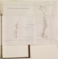
Sheet III, map reproduced by the Survey of Egypt, and appearing as an appendix to the Agreement between His Majesty's Government and the French Government respecting the Boundary Line between Syria and Palestine from the Mediterranean to El Hammé (1923).
The map shows the boundary along the shores of Lake Tiberias [the Sea of Galilee]. The work is Plane-table on Trigonometrical Survey Form lines at rough intervals of 100 feet, and shows trigonometrical points, intersected points, boundary posts, roads, canals, wadis, and water streams.
- Extent and format
- 1 map
- Area map covers
- Map loading...
- Scale
- 1:100000
- Scale designator
- Horizontal
- Orientation
- North
- Degree coordinates
- Top-left: 32° 53' 51.72" N, 35° 29' 33.72" E
Top-right: 32° 53' 51.72" N, 35° 41' 25.8" E
Bottom-left: 32° 42' 16.92" N, 35° 29' 33.72" E
Bottom-right: 32° 42' 16.92" N, 35° 41' 25.8" E - It is part of
- 788 imagesRef: IOR/L/PS/12/2848
- Physical characteristics
Materials: printed on paper.
Dimensions: 275 x 390mm, on sheet 340 x 425mm.
- Written in
- English in Latin script
- Type
- Map
Archive information for this record
- Original held at
- British Library: India Office The department of the British Government to which the Government of India reported between 1858 and 1947. The successor to the Court of Directors. Records and Private Papers Documents collected in a private capacity.
- Access conditions
Unrestricted
- Archive reference
- IOR/L/PS/12/2848, f 343
- Date(s)
- 1922 (CE, Gregorian)
Access & Reference
History of this record
Use and share this record
- Share this record
- Cite this record in your research
'MAP SHOWING BOUNDARY BETWEEN SYRIA AND PALESTINE: SHEET III', British Library: India Office Records and Private Papers, IOR/L/PS/12/2848, f 343, in Qatar Digital Library <https://www.qdl.qa/archive/81055/vdc_100054849850.0x000006> [accessed 26 April 2024]
- Link to this record
https://www.qdl.qa/en/archive/81055/vdc_100054849850.0x000006
- IIIF details
This record has a IIIF manifest available as follows. If you have a compatible viewer you can drag the icon to load it.https://www.qdl.qa/en/iiif/81055/vdc_100000000602.0x000186/manifestOpen in Universal viewerOpen in Mirador viewerMore options for embedding images
Copyright: How to use this content
- Reference
- IOR/L/PS/12/2848, f 343
- Title
- 'MAP SHOWING BOUNDARY BETWEEN SYRIA AND PALESTINE: SHEET III'
- Pages
- 343r:343v
- Author
- Unknown
- Usage terms
- The copyright status is unknown. Please contact copyright@bl.uk with any information you have regarding this item.