!['BAHRAIN & VICINITY.' [‎200Ar] (1/2)](https://iiif.qdl.qa/iiif/images/81055/vdc_100000000648.0x000176/IOR_L_PS_12_3806B_00407.jp2/full/!1200,1200/0/default.jpg "'BAHRAIN & VICINITY.' [‎200Ar] (1/2)")
'BAHRAIN & VICINITY.' [200Ar] (1/2)
The record is made up of 1 map sheet. It was created in 18 May 1939. It was written in English. The original is part of the British Library: India Office The department of the British Government to which the Government of India reported between 1858 and 1947. The successor to the Court of Directors. Records and Private Papers Documents collected in a private capacity. .
About this item
- Content
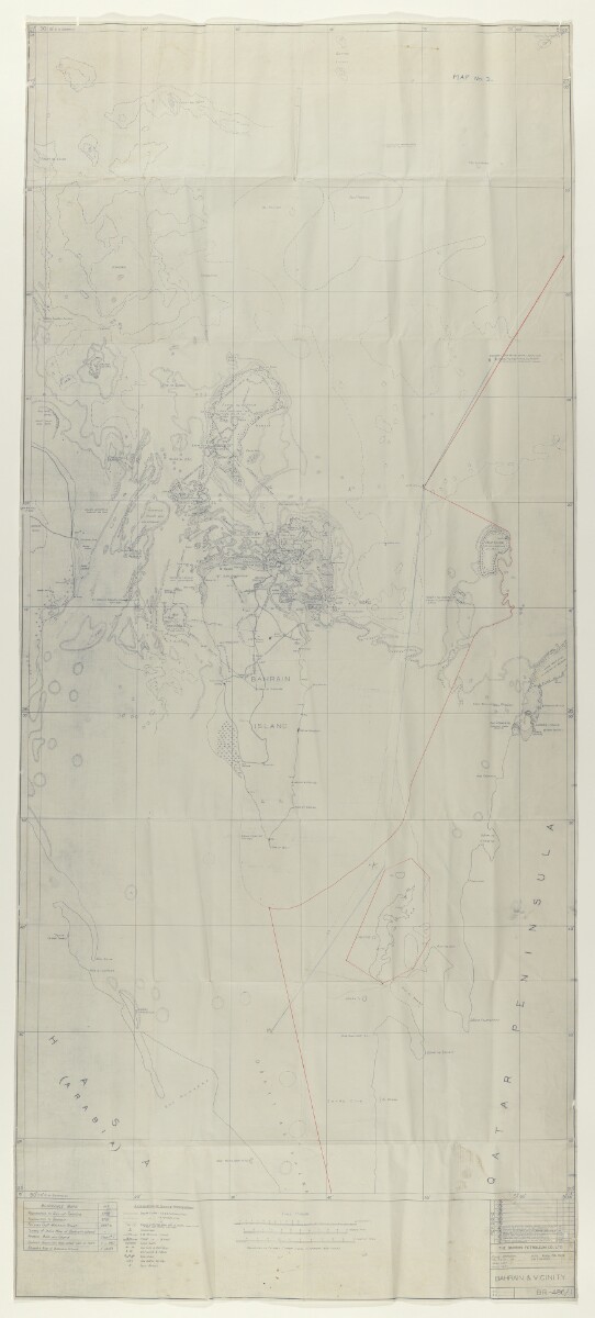
The map relates to letter No. 126 - S from the Political Resident A senior ranking political representative (equivalent to a Consul General) from the diplomatic corps of the Government of India or one of its subordinate provincial governments, in charge of a Political Residency. in the Persian Gulf The historical term used to describe the body of water between the Arabian Peninsula and Iran. to the India Office The department of the British Government to which the Government of India reported between 1858 and 1947. The successor to the Court of Directors. dated 18 January 1947, with enclosure (folios 179-198).
Map prepared by the Bahrain Petroleum Company from Admiralty charts and other information on record showing Bahrain, the coasts of Saudi Arabia and Qatar, and waters to the north, with shoals and reefs mapped in detail.
Inscribed in blue crayon: 'Map No. 2'.
Marked on verso The back of a sheet of paper or leaf, often abbreviated to 'v'. : 'BAHRAIN Island (in detail)' and 'BAHREIN-QATAR line'.
Recommendations for the division of waters between Bahrain and Qatar are marked with red and blue lines.
- Extent and format
- 1 map sheet
- Area map covers
- Map loading...
- Scale
- Scale 1:100,000
- Scale designator
- Horizontal
- Orientation
- North
- Degree coordinates
- Top-left: 27° 0' 36.72" N, 50° 0' 46.44" E
Top-right: 27° 0' 36.72" N, 51° 4' 39" E
Bottom-left: 25° 0' 9" N, 50° 0' 46.44" E
Bottom-right: 25° 0' 9" N, 51° 4' 39" E - Physical characteristics
Materials: blueprint on paper
Dimensions: 2210 x 960mm
- Written in
- English in Latin script View the complete information for this record
Use and share this item
- Share this item
'BAHRAIN & VICINITY.' [200Ar] (1/2), British Library: India Office Records and Private Papers, IOR/W/L/PS/12/3806B (ii), in Qatar Digital Library <https://www.qdl.qa/archive/81055/vdc_100056534851.0x000006> [accessed 19 July 2026]
https://www.qdl.qa/en/archive/81055/vdc_100056534851.0x000006
Copy and paste the code below into your web page where you would like to embed the image.
<meta charset="utf-8"><a href="https://www.qdl.qa/en/archive/81055/vdc_100056534851.0x000006">'BAHRAIN & VICINITY.' [‎200Ar] (1/2)</a> <a href="https://www.qdl.qa/en/archive/81055/vdc_100056534851.0x000006"> <img src="https://iiif.qdl.qa/iiif/images/81055/vdc_100000000648.0x000176/IOR_L_PS_12_3806B_00407.jp2/full/!280,240/0/default.jpg" alt="" /> </a>
This record has a IIIF manifest available as follows. If you have a compatible viewer you can drag the icon to load it.https://www.qdl.qa/en/iiif/81055/vdc_100000000648.0x000176/manifestOpen in Universal viewerOpen in Mirador viewerMore options for embedding images
Copyright: How to use this content
- Reference
- IOR/W/L/PS/12/3806B (ii)
- Title
- 'BAHRAIN & VICINITY.'
- Pages
- 200Ar, 200Av
- Author
- Bahrain Petroleum Company (BAPCO)
- Usage terms
- The copyright status is unknown. Please contact [email protected] with any information you have regarding this item.