'GENERAL MAP OF BAHRAIN ISLAND. PERSIAN GULF'
IOR/L/PS/12/3852, f 399

2 items in this record
Search within this record
The record is made up of 1 map. It was created in 1 Jun 1938. It was written in English. The original is part of the British Library: India Office The department of the British Government to which the Government of India reported between 1858 and 1947. The successor to the Court of Directors. Records and Private Papers Documents collected in a private capacity. .
About this record
- Content
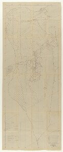
General map of Bahrain Island, produced by the Bahrain Petroleum Company (BAPCO).
The map shows:
- Shaikh of Bahrain's private property, excluded from the Company's Concession
- villages
- gardens
- Company reservations
- roads
- salt marshes
- ancient burial grounds
- sand dunes
- water wells
- fencing
- oil lines
- well water lines
- condensed water lines
- sewer lines
- gas lines
- telephone lines
- power lines
- locations
- abandoned locations
- rig completed
- drilling well
- drilling well abandoned
- producing oil well
The map supersedes map F-956, dated 21 May 1934.
- Extent and format
- 1 map
- Area map covers
- Map loading...
- Scale
- Scale 1:2,400
- Scale designator
- Horizontal
- Orientation
- North
- Degree coordinates
- Top-left: 26° 14' 41.18" N, 50° 26' 32.47" E
Top-right: 26° 14' 41.18" N, 50° 38' 39.21" E
Bottom-left: 25° 47' 30.67" N, 50° 26' 32.47" E
Bottom-right: 25° 47' 30.67" N, 50° 38' 39.21" E - It is part of
- Coll 30/123 'Bahrain (Unallotted Zone) Oil Concession: Negotiations with Petroleum Concessions Ltd.'801 imagesRef: IOR/L/PS/12/3852
- Physical characteristics
Materials: blueprint
Dimensions: 2120 x 830mm, on sheet 2220 x 880mm
- Written in
- English in Latin script
- Type
- Map
Archive information for this record
- Original held at
- British Library: India Office The department of the British Government to which the Government of India reported between 1858 and 1947. The successor to the Court of Directors. Records and Private Papers Documents collected in a private capacity.
- Access conditions
Unrestricted
- Archive reference
- IOR/L/PS/12/3852, f 399
- Former external reference(s)
- BR-477
- Date(s)
- 1 Jun 1938 (CE, Gregorian)
Access & Reference
History of this record
Use and share this record
- Share this record
- Cite this record in your research
'GENERAL MAP OF BAHRAIN ISLAND. PERSIAN GULF', British Library: India Office Records and Private Papers, IOR/L/PS/12/3852, f 399, in Qatar Digital Library <https://www.qdl.qa/archive/81055/vdc_100070100331.0x000002> [accessed 3 July 2026]
- Link to this record
https://www.qdl.qa/en/archive/81055/vdc_100070100331.0x000002
- IIIF details
This record has a IIIF manifest available as follows. If you have a compatible viewer you can drag the icon to load it.https://www.qdl.qa/en/iiif/81055/vdc_100000000648.0x0001a4/manifestOpen in Universal viewerOpen in Mirador viewerMore options for embedding images
Copyright: How to use this content
- Reference
- IOR/L/PS/12/3852, f 399
- Title
- 'GENERAL MAP OF BAHRAIN ISLAND. PERSIAN GULF'
- Pages
- 399r:399v
- Author
- Bahrain Petroleum Company (BAPCO)
- Usage terms
- The copyright status is unknown. Please contact [email protected] with any information you have regarding this item.