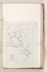
‘Sketch Map of the Vilayet of Basra’
IOR/L/PS/10/596, f 295
2 items in this record
Search within this record
The record is made up of 1 map. It was created in 1914. It was written in English. The original is part of the British Library: India Office The department of the British Government to which the Government of India reported between 1858 and 1947. The successor to the Court of Directors. Records and Private Papers Documents collected in a private capacity. .
About this record
- Content
Map showing the vilayet, or administrative district of Basra, Mesopotamia [Iraq]. The map indicates: the city of Basra, Muhamrah [Khorramshahr], and other surrounding towns; the boundary of the vilayet as a dotted and dashed line; coastline; the Euphrates and Tigris rivers and their tributaries. A note at the bottom of the map indicates that it was produced by the Ordnance Survey Office in 1914. The map is part of a diplomatic and consular report on trade in Basra, edited at the Foreign Office and Board of Trade, and presented to both Houses of Parliament in August 1914 (ff 293-303).
- Extent and format
- 1 map
- Area map covers
- Map loading...
- Scale
- Scale approximately 1:1,714,000
- Scale designator
- Horizontal
- Orientation
- North
- Degree coordinates
- Top-left: 32° 25' 0.48" N, 46° 5' 38.04" E
Top-right: 32° 25' 0.48" N, 48° 33' 56.88" E
Bottom-left: 28° 49' 51.96" N, 46° 5' 38.04" E
Bottom-right: 28° 49' 51.96" N, 48° 33' 56.88" E - It is part of
- 709 imagesRef: IOR/L/PS/10/596
- Physical characteristics
Dimensions: 200 x 140mm, on sheet 240 x 180mm.
Materials: black ink on paper.
- Written in
- English in Latin script
- Type
- Map
Archive information for this record
- Original held at
- British Library: India Office The department of the British Government to which the Government of India reported between 1858 and 1947. The successor to the Court of Directors. Records and Private Papers Documents collected in a private capacity.
- Access conditions
Unrestricted
- Archive reference
- IOR/L/PS/10/596, f 295
- Date(s)
- 1914 (CE, Gregorian)
Access & Reference
History of this record
Use and share this record
- Share this record
- Cite this record in your research
‘Sketch Map of the Vilayet of Basra’, British Library: India Office Records and Private Papers, IOR/L/PS/10/596, f 295, in Qatar Digital Library <https://www.qdl.qa/archive/81055/vdc_100079399483.0x000001> [accessed 7 May 2024]
- Link to this record
https://www.qdl.qa/en/archive/81055/vdc_100079399483.0x000001
- IIIF details
This record has a IIIF manifest available as follows. If you have a compatible viewer you can drag the icon to load it.https://www.qdl.qa/en/iiif/81055/vdc_100000000419.0x0001eb/manifestOpen in Universal viewerOpen in Mirador viewerMore options for embedding images
Copyright: How to use this content
- Reference
- IOR/L/PS/10/596, f 295
- Title
- ‘Sketch Map of the Vilayet of Basra’
- Pages
- 295r:295v
- Author
- East India Company, the Board of Control, the India Office, or other British Government Department
- Usage terms
- Open Government Licence