!['OILFIELDS & CONCESSION AREAS IN THE MIDDLE EASTERN COUNTRIES TOGETHER WITH NEIGHBOURING OILFIELDS IN THE U.S.S.R.' [‎28r] (1/2)](https://iiif.qdl.qa/iiif/images/81055/vdc_100000000648.0x000212/IOR_L_PS_12_3959_0058.jp2/full/!1200,1200/0/default.jpg "'OILFIELDS & CONCESSION AREAS IN THE MIDDLE EASTERN COUNTRIES TOGETHER WITH NEIGHBOURING OILFIELDS IN THE U.S.S.R.' [‎28r] (1/2)")
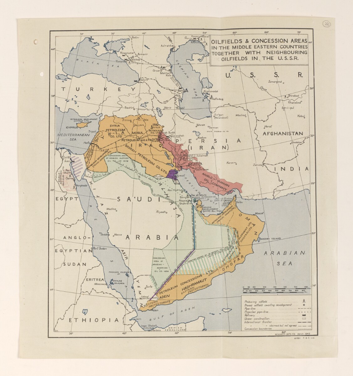
'OILFIELDS & CONCESSION AREAS IN THE MIDDLE EASTERN COUNTRIES TOGETHER WITH NEIGHBOURING OILFIELDS IN THE U.S.S.R.' [28r] (1/2)
The record is made up of 1 map. It was created in Mar 1945. It was written in English. The original is part of the British Library: India Office The department of the British Government to which the Government of India reported between 1858 and 1947. The successor to the Court of Directors. Records and Private Papers Documents collected in a private capacity. .
About this item
- Content
Map produced by the Research Department of the Foreign Office to accompany the document 'A Survey of the Oil Resources in the Middle East ', dated 28 February 1945 (folios 18-30), showing all the known oilfields and concession areas of the Middle East along with neighbouring oilfields in Persia, Afghanistan and the Union of Soviet Socialist Republics (USSR).
The oilfields and concession areas are coloured in, with those in Iraq, Qatar, the Trucial Coast A name used by Britain from the nineteenth century to 1971 to refer to the present-day United Arab Emirates. , Oman and Aden coloured orange; those in Saudi Arabia and Bahrain coloured green; Kuwait coloured purple; and Persia coloured pink. There are also two areas of Egypt which have been marked with striped coloured lines, the area west of Suez marked with red stripes, and an area east of Suez marked with purple stripes.
There are also two coloured lines marked on the map, running primarily through Saudi Arabia. The 'Violet Line' line marks the boundary of Ottoman territory and the 'Blue Line' the boundary of the Sanjaq of Najd. These lines are both marked according to the Anglo-Turkish Convention of 1913, which was unratified.
A key is located in the bottom right hand corner of the map and includes symbols for: producing oilfields, proven oilfields, pipelines, projected pipelines, existing refineries, and refineries under construction.
- Extent and format
- 1 map
- Area map covers
- Map loading...
- Scale
- Scale approximately 1:600
- Scale designator
- Horizontal
- Orientation
- North
- Degree coordinates
- Top-left: 47° 49' 48" N, 25° 45' 36" E
Top-right: 47° 49' 48" N, 71° 45' 0" E
Bottom-left: 10° 5' 24" N, 25° 45' 36" E
Bottom-right: 10° 5' 24" N, 71° 45' 0" E - Written in
- English in Latin script View the complete information for this record
Use and share this item
- Share this item
'OILFIELDS & CONCESSION AREAS IN THE MIDDLE EASTERN COUNTRIES TOGETHER WITH NEIGHBOURING OILFIELDS IN THE U.S.S.R.' [28r] (1/2), British Library: India Office Records and Private Papers, IOR/L/PS/12/3959, f 28, in Qatar Digital Library <https://www.qdl.qa/archive/81055/vdc_100080229055.0x000038> [accessed 23 April 2024]
https://www.qdl.qa/en/archive/81055/vdc_100080229055.0x000038
Copy and paste the code below into your web page where you would like to embed the image.
<meta charset="utf-8"><a href="https://www.qdl.qa/en/archive/81055/vdc_100080229055.0x000038">'OILFIELDS & CONCESSION AREAS IN THE MIDDLE EASTERN COUNTRIES TOGETHER WITH NEIGHBOURING OILFIELDS IN THE U.S.S.R.' [‎28r] (1/2)</a> <a href="https://www.qdl.qa/en/archive/81055/vdc_100080229055.0x000038"> <img src="https://iiif.qdl.qa/iiif/images/81055/vdc_100000000648.0x000212/IOR_L_PS_12_3959_0058.jp2/full/!280,240/0/default.jpg" alt="" /> </a>
This record has a IIIF manifest available as follows. If you have a compatible viewer you can drag the icon to load it.https://www.qdl.qa/en/iiif/81055/vdc_100000000648.0x000212/manifestOpen in Universal viewerOpen in Mirador viewerMore options for embedding images
Copyright: How to use this content
- Reference
- IOR/L/PS/12/3959, f 28
- Title
- 'OILFIELDS & CONCESSION AREAS IN THE MIDDLE EASTERN COUNTRIES TOGETHER WITH NEIGHBOURING OILFIELDS IN THE U.S.S.R.'
- Pages
- 28r, 28r
- Author
- East India Company, the Board of Control, the India Office, or other British Government Department
- Usage terms
- Open Government Licence