![‘Rough Sketch Showing Shuwaikh area to be reserved for K.O.C. use’ [‎170r] (1/2)](https://iiif.qdl.qa/iiif/images/81055/vdc_100000000193.0x00026c/IOR_R_15_1_646_0360.jp2/full/!1200,1200/0/default.jpg "‘Rough Sketch Showing Shuwaikh area to be reserved for K.O.C. use’ [‎170r] (1/2)")
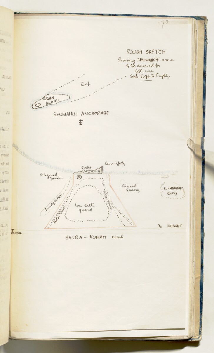
‘Rough Sketch Showing Shuwaikh area to be reserved for K.O.C. use’ [170r] (1/2)
The record is made up of 1 map. It was created in 1936. It was written in English. The original is part of the British Library: India Office The department of the British Government to which the Government of India reported between 1858 and 1947. The successor to the Court of Directors. Records and Private Papers Documents collected in a private capacity. .
Transcription
This transcription is created automatically. It may contain errors.
/73
Cotifideni ial
Otfioa of the Political
I es id e nt is the Persien Gulf,
Camp, Kuwait•
Dated the 30tii November I'JZtS*
i)#0>ho»c/2^5
Could you plicae refer to my ixpreaa
Letter No.c/246 dated the 29th foveasfeer 1936
on the subject of the Bandar Shuwalkh site*
The Shaikh w mid like to toe a tale to
be in a position to reply to the Company as
soon aa possible* Could you please, therefore,
let me h^ve an early reply*
<f
M.J.Clauson Require,
fue
India Office
The department of the British Government to which the Government of India reported between 1858 and 1947. The successor to the Court of Directors.
*
London*
i
L
(Copy sent to P#A#Kuwait undeT d#o # P # L.
No. G/256 of 30/11/36).
About this item
- Content
Distinctive Features:
Hand drawn sketch map enclosed with a copy of a letter no. 6810 dated 8th November 1936 showing plot of land in the Shuwaikh area intended for the Kuwait Oil Company landing operations.
The extent of the land indicated in red line with motor tracks and the Jahra-Kuwait road labelled. Shows the Shuwaikh anchorage, the location of Al Ghanims Quarry, an octagonal Coat Tower and the Cement Pier marked.
- Extent and format
- 1 map
- Area map covers
- Map loading...
- Scale
- Scale approximately 1:4,800
- Scale designator
- Horizontal
- Orientation
- North
- Degree coordinates
- Top-left: 29° 22' 7.02" N, 47° 52' 19.01" E
Top-right: 29° 22' 7.02" N, 47° 57' 15.64" E
Bottom-left: 29° 18' 3.72" N, 47° 52' 19.01" E
Bottom-right: 29° 18' 3.72" N, 47° 57' 15.64" E - Physical characteristics
Materials: Pen and ink with crayon on paper
Dimensions: 316 x 180 mm
- Written in
- English in Latin script View the complete information for this record
Use and share this item
- Share this item
‘Rough Sketch Showing Shuwaikh area to be reserved for K.O.C. use’ [170r] (1/2), British Library: India Office Records and Private Papers, IOR/R/15/1/646, f 170, in Qatar Digital Library <https://www.qdl.qa/archive/81055/vdc_100080764581.0x00009d> [accessed 14 June 2026]
https://www.qdl.qa/en/archive/81055/vdc_100080764581.0x00009d
Copy and paste the code below into your web page where you would like to embed the image.
<meta charset="utf-8"><a href="https://www.qdl.qa/en/archive/81055/vdc_100080764581.0x00009d">‘Rough Sketch Showing Shuwaikh area to be reserved for K.O.C. use’ [‎170r] (1/2)</a> <a href="https://www.qdl.qa/en/archive/81055/vdc_100080764581.0x00009d"> <img src="https://iiif.qdl.qa/iiif/images/81055/vdc_100000000193.0x00026c/IOR_R_15_1_646_0360.jp2/full/!280,240/0/default.jpg" alt="" /> </a>
This record has a IIIF manifest available as follows. If you have a compatible viewer you can drag the icon to load it.https://www.qdl.qa/en/iiif/81055/vdc_100000000193.0x00026c/manifestOpen in Universal viewerOpen in Mirador viewerMore options for embedding images
Copyright: How to use this content
- Reference
- IOR/R/15/1/646, f 170
- Title
- ‘Rough Sketch Showing Shuwaikh area to be reserved for K.O.C. use’
- Pages
- 170r:170v
- Author
- Kuwait Oil Company
- Usage terms
- The copyright status is unknown. Please contact [email protected] with any information you have regarding this item.