!['TRACING SHOWING THE ROUTE AND COAST LINE FROM MOGOO BAY TO THE TOWN OF BUNDER ABBAS. (VIDE REPORT NO. 6 OF 1864)' [‎236a] (1/2)](https://iiif.qdl.qa/iiif/images/81055/vdc_100085203917.0x000001/ST 393_vol 17_0423.jp2/full/!1200,1200/0/default.jpg "'TRACING SHOWING THE ROUTE AND COAST LINE FROM MOGOO BAY TO THE TOWN OF BUNDER ABBAS. (VIDE REPORT NO. 6 OF 1864)' [‎236a] (1/2)")
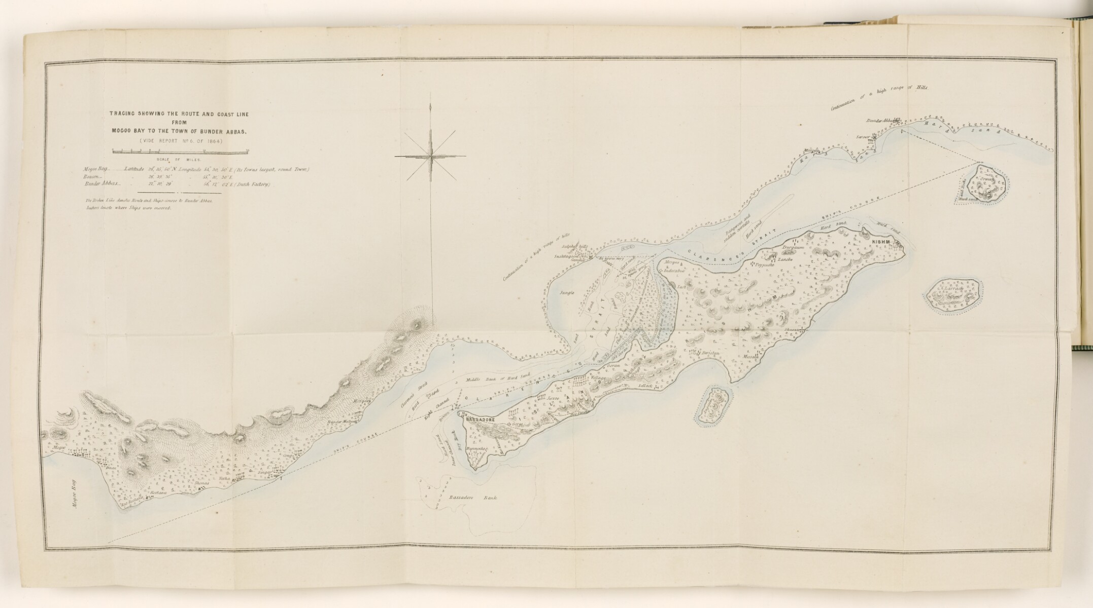
'TRACING SHOWING THE ROUTE AND COAST LINE FROM MOGOO BAY TO THE TOWN OF BUNDER ABBAS. (VIDE REPORT NO. 6 OF 1864)' [236a] (1/2)
The record is made up of 1 map. It was created in c 1864. It was written in English. The original is part of the British Library: India Office The department of the British Government to which the Government of India reported between 1858 and 1947. The successor to the Court of Directors. Records and Private Papers Documents collected in a private capacity. .
About this item
- Content
The map accompanies The Transactions of the Bombay Geographical Society. From January 1863 to December 1864. (Edited by the Secretary.) Volume XVII : Article XV (pages 237-255), entitled 'Remarks on the Port of Lingah, the Island of Kishm, and the Port of Bunder Abbass, and its neighbourhood.', by Lieutenant-Colonel Lewis Pelly, Political Resident A senior ranking political representative (equivalent to a Consul General) from the diplomatic corps of the Government of India or one of its subordinate provincial governments, in charge of a Political Residency. in the Persian Gulf The historical term used to describe the body of water between the Arabian Peninsula and Iran. .
The map shows Pelly's line of route (by sea), the coastline between Mogoo Bay and Bunder Abbass [Bandar Abbas], and the island of Kishm. The map indicates settlements. Relief shown by hachures Lines drawn on a map to indicate the direction and steepness of slope. . Depth shown by soundings Measurements of the depth of a body of water. .
A broken line indicates the route, and ship's course to Bandar Abbas, while anchors indicate where ships were moored.
- Extent and format
- 1 map
- Area map covers
- Map loading...
- Scale
- Scale approximately 1:300,000
- Scale designator
- Horizontal
- Orientation
- North
- Degree coordinates
- Top-left: 27° 15' 5.67" N, 54° 27' 47.09" E
Top-right: 27° 15' 5.67" N, 56° 36' 11.79" E
Bottom-left: 26° 25' 37.53" N, 54° 27' 47.09" E
Bottom-right: 26° 25' 37.53" N, 56° 36' 11.79" E - Physical characteristics
Materials: Printed on paper
Dimensions: 310 x 640mm, on sheet 360 x 670mm
- Written in
- English in Latin script View the complete information for this record
Use and share this item
- Share this item
'TRACING SHOWING THE ROUTE AND COAST LINE FROM MOGOO BAY TO THE TOWN OF BUNDER ABBAS. (VIDE REPORT NO. 6 OF 1864)' [236a] (1/2), British Library: India Office Records and Private Papers, ST 393, vol 17, p 236a, in Qatar Digital Library <https://www.qdl.qa/archive/81055/vdc_100099749668.0x00000b> [accessed 4 June 2026]
https://www.qdl.qa/en/archive/81055/vdc_100099749668.0x00000b
Copy and paste the code below into your web page where you would like to embed the image.
<meta charset="utf-8"><a href="https://www.qdl.qa/en/archive/81055/vdc_100099749668.0x00000b">'TRACING SHOWING THE ROUTE AND COAST LINE FROM MOGOO BAY TO THE TOWN OF BUNDER ABBAS. (VIDE REPORT NO. 6 OF 1864)' [‎236a] (1/2)</a> <a href="https://www.qdl.qa/en/archive/81055/vdc_100099749668.0x00000b"> <img src="https://iiif.qdl.qa/iiif/images/81055/vdc_100085203917.0x000001/ST 393_vol 17_0423.jp2/full/!280,240/0/default.jpg" alt="" /> </a>
This record has a IIIF manifest available as follows. If you have a compatible viewer you can drag the icon to load it.https://www.qdl.qa/en/iiif/81055/vdc_100085203917.0x000001/manifestOpen in Universal viewerOpen in Mirador viewerMore options for embedding images
Copyright: How to use this content
- Reference
- ST 393, vol 17, p 236a
- Title
- 'TRACING SHOWING THE ROUTE AND COAST LINE FROM MOGOO BAY TO THE TOWN OF BUNDER ABBAS. (VIDE REPORT NO. 6 OF 1864)'
- Pages
- 236a:236b
- Author
- Bombay Geographical Society
- Usage terms
- Public Domain