!['Chart of The Gulf of Persia.' [‎1r] (1/4)](https://iiif.qdl.qa/iiif/images/81055/vdc_100138047391.0x000001/IOR_X_3635_35_1-2_0001.jp2/full/!1200,1200/0/default.jpg "'Chart of The Gulf of Persia.' [‎1r] (1/4)")
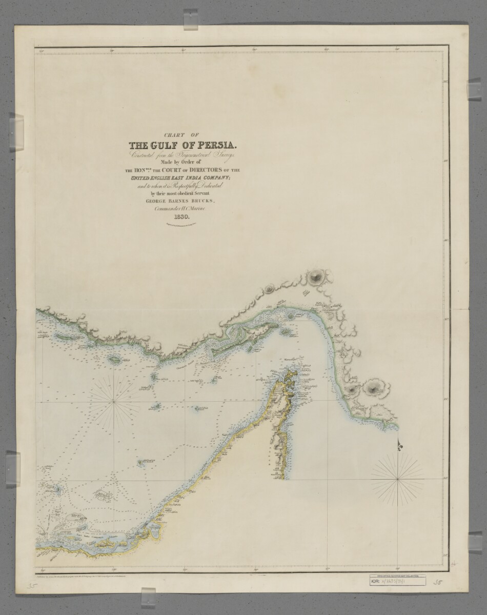
'Chart of The Gulf of Persia.' [1r] (1/4)
The record is made up of 1 map on 2 sheets. It was created in 1832. It was written in English and Arabic. The original is part of the British Library: Map Collections.
About this item
- Content
Sheet 1 (Eastern) bears the shelfmark IOR/X/3635/1
Sheet 2 (Western) bears the shelfmark IOR/X/3635/2
Covers the Persian Gulf The historical term used to describe the body of water between the Arabian Peninsula and Iran. , Strait of Hormuz and the coastlines of Persia [Iran], Mesopotamia and the north-eastern Arabian Peninsula eastwards to the Musandam Peninsula. Includes a hinterland of approximately twelve miles. Portrays hydrology, including depths by soundings Measurements of the depth of a body of water. , and rocks, relief by hachures Lines drawn on a map to indicate the direction and steepness of slope. and rock drawing, vegetation, settlements and place names in English and Arabic, and includes topographical and hydrographic notes. The coastlines are highlighted in watercolour.
'Constructed from the Trigonometrical Surveys. Made by Order of the Hon[ourab]le the Court of Directors The London-based directors of the East India Company who dealt with the daily conduct of the Company's affairs. of the United English East India Company; and to whom it is Respectfully Dedicated by their most obedient Servant George Barnes Brucks, Commander HC [Honourable Company] Marine. 1830.'
Original surveys by Lieutenants John Michael Guy, George Barnes Brucks, Robert Cogan, William Eales Rogers and Stafford Bettesworth Haines, 1821-29. Engraved by Richard Bateman. Published by James Horsburgh, Hydrographer to the Honourable East India Company, 1832.
- Extent and format
- 1 map on 2 sheets
- Area map covers
- Map loading...
- Scale
- Scale approximately 1:1,000,000
- Scale designator
- Horizontal
- Orientation
- North
- Degree coordinates
- Top-left: 30° 19' 59.88" N, 47° 10' 30" E
Top-right: 30° 19' 59.88" N, 58° 38' 30.12" E
Bottom-left: 23° 55' 0.12" N, 47° 10' 30" E
Bottom-right: 23° 55' 0.12" N, 58° 38' 30.12" E - Physical characteristics
Materials: Printed, with manuscript additions in watercolour, on paper (backed with linen)
Dimensions: Sheet 1 (Eastern) 725 x 580mm, on sheet 803 x 644mm; Sheet 2 (Western) 731 x 580mm, on sheet 820 x 648mm
- Written in
- English and Arabic in Latin and Arabic script View the complete information for this record
Use and share this item
- Share this item
'Chart of The Gulf of Persia.' [1r] (1/4), British Library: Map Collections, IOR/X/3635/35/1-2, in Qatar Digital Library <https://www.qdl.qa/archive/81055/vdc_100148932718.0x000002> [accessed 6 June 2026]
https://www.qdl.qa/en/archive/81055/vdc_100148932718.0x000002
Copy and paste the code below into your web page where you would like to embed the image.
<meta charset="utf-8"><a href="https://www.qdl.qa/en/archive/81055/vdc_100148932718.0x000002">'Chart of The Gulf of Persia.' [‎1r] (1/4)</a> <a href="https://www.qdl.qa/en/archive/81055/vdc_100148932718.0x000002"> <img src="https://iiif.qdl.qa/iiif/images/81055/vdc_100138047391.0x000001/IOR_X_3635_35_1-2_0001.jp2/full/!280,240/0/default.jpg" alt="" /> </a>
This record has a IIIF manifest available as follows. If you have a compatible viewer you can drag the icon to load it.https://www.qdl.qa/en/iiif/81055/vdc_100138047391.0x000001/manifestOpen in Universal viewerOpen in Mirador viewerMore options for embedding images
Copyright: How to use this content
- Reference
- IOR/X/3635/35/1-2
- Title
- 'Chart of The Gulf of Persia.'
- Pages
- 1r:2v
- Author
- East India Company, the Board of Control, the India Office, or other British Government Department
- Usage terms
- Public Domain
- Reference
- IOR/X/3635/35/1-2
- Title
- 'Chart of The Gulf of Persia.'
- Pages
- 1r:2v
- Author
- Bateman, Richard
- Usage terms
- Public Domain