
!['A General Chart of the part of the Karun River about Awaz, including the Bund and of the River Karun and Dizful Aubi Gargar Canal' [‎290r] (1/2)](https://iiif.qdl.qa/iiif/images/81055/vdc_100000001491.0x000333/Mss Eur F112_611_0642.jp2/full/!1200,1200/0/default.jpg "'A General Chart of the part of the Karun River about Awaz, including the Bund and of the River Karun and Dizful Aubi Gargar Canal' [‎290r] (1/2)")
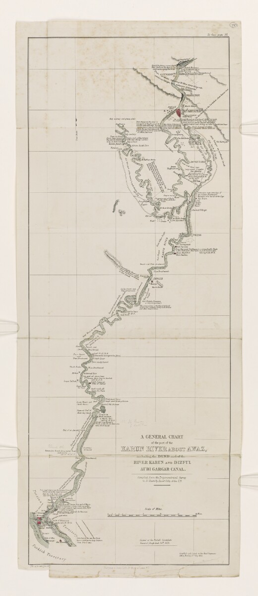
'A General Chart of the part of the Karun River about Awaz, including the Bund and of the River Karun and Dizful Aubi Gargar Canal' [290r] (1/2)
The record is made up of 1 map. It was created in 1878. It was written in English. The original is part of the British Library: India Office The department of the British Government to which the Government of India reported between 1858 and 1947. The successor to the Court of Directors. Records and Private Papers Documents collected in a private capacity. .
Transcription
This transcription is created automatically. It may contain errors.
To paqe 25,
(2s. s in /Mip/ ux
LaneWC
)4.m-
"ir, 1
GOTWAND'^
!\DOWLUTABAD
bearing N. 16.30^.
Thirv^rashMfOod/
°34~*,
AHWAZ
+&Popl
yella
Sfo
Bar&^
li^Furt 1
A GENERAL CHART
RIVER KAREN AND BIZFUL
Scale. of Miles.
K
SwO/mpy
Ground
Good Wood/
I for fuel/
%
3
"me
bsG
£
3
ComjUeAanAi Copied in the Chief Etwuuov
Office''May 1845.
8
f-
8
g
4
)—-WatchTower
Bare sancfyDe/serb
^Mosque^ff^c^
From here tv the sea \e River
has a ccniinuciis deep channel
from 3 to suns.
tempi led/ from IheTriyanAm^lrvcaL Survey
in 5 Sheets by LieMSelby ofthe/ IN.
9<:(
Imari/ \
MaghashenutAb
Copied. at the British Consulate
Creneral,Baghdad ,25^/ 1%78.
very tortuous channel/through
\ which/dto current/runs wiOo (
B greatvdoafyat'times lipwards'
cfSMles per hour. I
'illy cowdory
8
(
ur • •
Hobem Pm. Yacodb Pyramidal Tomb
and, spires .
_u Ltd.30‘. 35^30'^.
thab the Crcdclnah creek,
was cut> tn allow alb bcc^p
Shue-up/,
/ Good. wood/,all
U_along the Rank
ae
Sandy Desert and/ , k
Thin Brushwood/ $
2/
Al Kuir Arabs
9
2
,8
g
"Sernayeeat
EKa Karaaou
) From- this point Tut/Rayanb A remarkable Fealc
A 21Al,,
Kjlpii riun/,remains or
» (;il on/ancient/Roostabadc
y 4, Remains oto/ bund- or bridge
", Old Fnam/
s4Ol
* ^Bank/
^of thl
River
Ruined/ Village
a
ge® r
ga
, Rad
AarMohaisis
— 9
•)$
2/8
yy
fl
। •
}
/
sk-E WEISS
sa
e
it is said rhat ascmcH'arik was femt
RafheerArabs
1 ,3*
***3
V, Kut Abdula/Runains
2/ a very large/ Canal/
This promontory is thickly inhabited/
during die Summer mcstfybv die Bowee-
and other ChaaJb tribes.
GoodJungle d 00 ^ Witting Statu
‘Ruined WatchTwer
,,=f Wood Station/
2 E in March 134-1.
thin A ig Brushwood,
About this item
- Content
This map shows the route of the Karun River in Persia [Iran] roughly between Shuster and Mohamerah [Khorramshahr]. The map shows the settlements, archaeological sites, and cities along the lower half of the river as it flows into the Persian Gulf The historical term used to describe the body of water between the Arabian Peninsula and Iran. , as well as the canals, water works, and other hydraulic structures both ancient and modern built on the river.
- Extent and format
- 1 map
- Area map covers
- Map loading...
- Scale
- 1 cm = 2.5 miles
- Scale designator
- Horizontal
- Orientation
- North
- Degree coordinates
- Top-left: 32° 35' 15.36" N, 48° 5' 45.6" E
Top-right: 32° 35' 15.36" N, 48° 55' 51.6" E
Bottom-left: 30° 20' 2.76" N, 48° 5' 45.6" E
Bottom-right: 30° 20' 2.76" N, 48° 55' 51.6" E - Physical characteristics
Materials: Printed on paper
Dimensions: 640 x 250 mm
- Written in
- English in Latin script View the complete information for this record
Use and share this item
- Share this item
'A General Chart of the part of the Karun River about Awaz, including the Bund and of the River Karun and Dizful Aubi Gargar Canal' [290r] (1/2), British Library: India Office Records and Private Papers, Mss Eur F112/611, f 290, in Qatar Digital Library <https://www.qdl.qa/archive/81055/vdc_100149372606.0x0000b5> [accessed 10 July 2026]
https://www.qdl.qa/en/archive/81055/vdc_100149372606.0x0000b5
Copy and paste the code below into your web page where you would like to embed the image.
<meta charset="utf-8"><a href="https://www.qdl.qa/en/archive/81055/vdc_100149372606.0x0000b5">'A General Chart of the part of the Karun River about Awaz, including the Bund and of the River Karun and Dizful Aubi Gargar Canal' [‎290r] (1/2)</a> <a href="https://www.qdl.qa/en/archive/81055/vdc_100149372606.0x0000b5"> <img src="https://iiif.qdl.qa/iiif/images/81055/vdc_100000001491.0x000333/Mss Eur F112_611_0642.jp2/full/!280,240/0/default.jpg" alt="" /> </a>
This record has a IIIF manifest available as follows. If you have a compatible viewer you can drag the icon to load it.https://www.qdl.qa/en/iiif/81055/vdc_100000001491.0x000333/manifestOpen in Universal viewerOpen in Mirador viewerMore options for embedding images
Copyright: How to use this content
- Reference
- Mss Eur F112/611, f 290
- Title
- 'A General Chart of the part of the Karun River about Awaz, including the Bund and of the River Karun and Dizful Aubi Gargar Canal'
- Pages
- 290r:290v
- Author
- East India Company, the Board of Control, the India Office, or other British Government Department
- Usage terms
- Public Domain