!["تقرير عسكري عن جنوب غرب بلاد فارس، يتضمن أقاليم خوزستان (عربستان)، لورستان، وجزءًا من فارس" [<span dir="ltr">٢٣٦</span>] (٤٦٦/٢٥٧)](https://iiif.qdl.qa/iiif/images/81055/vdc_100023517327.0x000001/V 8685_0277.jp2/full/!1200,1200/0/default.jpg "\"تقرير عسكري عن جنوب غرب بلاد فارس، يتضمن أقاليم خوزستان (عربستان)، لورستان، وجزءًا من فارس\" [<span dir=\"ltr\">٢٣٦</span>] (٤٦٦/٢٥٧)")
"تقرير عسكري عن جنوب غرب بلاد فارس، يتضمن أقاليم خوزستان (عربستان)، لورستان، وجزءًا من فارس" [٢٣٦] (٤٦٦/٢٥٧)
محتويات السجل: مجلد واحد (٣٩٠ صفحة). يعود تاريخه إلى ١٨٨٥. اللغة أو اللغات المستخدمة: الإنجليزية. النسخة الأصلية محفوظة في المكتبة البريطانية: مجموعات مطبوعة.
نسخ
النسخ مستحدث آليًا ومن المرجّح أن يحتوي على أخطاء.
236
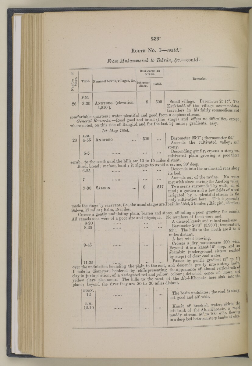
R oute N o. \—contd.
From Muhawmerah to Tehran, fyc. —contd.
S 6 d
, o ci
as
26
Time.
p.m.
3-30
Names of towns, villages, &c.
distahtces in"
miles.
Interme
diate.
Anetbbg (elevation
4,910').
Total.
Eemarks.
509 Small village. Barometer 25-15". Tlie
Katkhuda of the village accommodates
travellers in his fairly commodious and
comfortable 'quarters ; water plentiful and good from a copious stream.
General Bemarlks.—RoaA good and broad (this stage) and offers no difficulties, except
wbere noted, on tbis side of Eaugird and for the last li miles ; gradients, easy.
1st JULay 1884,
Anetbeg 509 ... Barometer 25*1^; thermometer 64. c
Ascends the cultivated valley; soil,
stony.
Descending gently, crosses a stony un
cultivated plain growing a poor thorn
to the southward the hills are 10 to 15 miles distant.
26
a.m.
4-55
5-5
scrub
ID ! to tlUJ bUULU W 0)1 VA. X X ^ , OAf
Koad, broad; surface, hard ; it zigzags to avoid a ravine, 30 deep.
6-25
7-30
Descends into the ravine and runs along
its bed.
Ascends out of the ravine. No water
met with since leaving the Anetheg vallej.
q/ T T?/"i"w 8 517 Two serais surrounded by walls, all of.
mud; a garden and a few fields of wheat
irrigated by a plentiful stream is the
only cultivation here. This is generally
made the stage by caravans, i.e., the usual stages are Ibrahimabad, 24 miles ; Raugird, 23 miles;
S41 XlssLt 1 gtn%tndukti!!g plain, barren and stony, affording a poor grazing for camels.
All camels seen were of a poor size and physique. No ^^Vkan^nTmined e.closure.
Barometer 26-0" (3,980'); temperature,
83 p . The bills to the north are 3 to 4
miles distant.
A hot wind blowing.
Crosses a dry watercourse 200 wide.
Beyond it is a kanat 15' deep, and an
abambar (underground cistern reached
by steps) of clear cool water.
8-20
*-35
9-45
11 ok t Passes by gentle gradient (3 to o j
over the undulation bounding the plain to the east, and descends rolb 6f
1 mile in diameter, bordered by cliffs presenting the appeaa-ance of almost veitica^ ^
clay in juxtaposition, of a variegated red and yellow colour ; f et ^ ehed ,° 0 , ; k into the
yellow clays also occur. The bills to the west of the Ab-i-Kbonsai beie smK m
plain ; beyond the river they are 20 to 30 miles distant.
The basin undulates; the road is stony,
noon.
12
p.m.
12-10
but good and 40' wide.
the
Kanat of brachish water; skirts
left bank of the Ab -i -Khonsar, a rapia
muddy stream, 60'.to 100 nf day.
deep bed between steep banks
m a
حول هذه المادة
- المحتوى
قرير عسكري عن جنوب غرب بلاد فارس، يتضمن أقاليم خوزستان (عربستان)، لورستان، وجزءًا من فارس بقلم الرائد والبارونيت. المقدم مارك س. بيل، وسام صليب فيكتوريا، فيلق المهندسين الملكي.
بيانات النشر: شيملا: مطبعة الفرع المركزي للحكومة، ١٨٨٥. أُعد في فرع الاستخبارات لإدارة قائد الإمداد والتموين في الهند.
الوصف المادي: ٣ خرائط في جيوب في النهاية. ٤١ لوحة.
- الشكل والحيّز
- مجلد واحد (٣٩٠ صفحة)
- الترتيب
يحتوي هذا المجلد على فهرس محتويات يشمل عناوين الفصول ومراجع الصفحات.
- الخصائص المادية
الأبعاد: ٢٤٥ مم × ١٥٠ مم
- لغة الكتابة
- الإنجليزية بالأحرف اللاتينية للاطّلاع على المعلومات الكاملة لهذا السجل
استخدام وإعادة نشر هذه المادة
- إعادة نشر هذه المادة
"تقرير عسكري عن جنوب غرب بلاد فارس، يتضمن أقاليم خوزستان (عربستان)، لورستان، وجزءًا من فارس" [٢٣٦] (٤٦٦/٢٥٧)و المكتبة البريطانية: مجموعات مطبوعةو V 8685و مكتبة قطر الرقمية <https://www.qdl.qa/archive/81055/vdc_100023694940.0x000038> [تم الوصول إليها في ١٤ May ٢٠٢٤]
https://www.qdl.qa/العربية/archive/81055/vdc_100023694940.0x000038
يمكنك نسخ ولصق الفقرة التالية لتضمين الصورة في صفحة الويب الخاصة بك.
<meta charset="utf-8"><a href="https://www.qdl.qa/العربية/archive/81055/vdc_100023694940.0x000038">"تقرير عسكري عن جنوب غرب بلاد فارس، يتضمن أقاليم خوزستان (عربستان)، لورستان، وجزءًا من فارس" [<span dir="ltr">٢٣٦</span>] (٤٦٦/٢٥٧)</a> <a href="https://www.qdl.qa/العربية/archive/81055/vdc_100023694940.0x000038"> <img src="https://iiif.qdl.qa/iiif/images/81055/vdc_100023517327.0x000001/V 8685_0277.jp2/full/!280,240/0/default.jpg" alt="" /> </a>
هذا التسجيل IIIF له ملف ظاهر متوفر كما يلي. إذا كان لديك عارض متوافق للصور يمكنك سحب الأيقونة لتحميله.https://www.qdl.qa/العربية/iiif/81055/vdc_100023517327.0x000001/manifestافتح في المتصفح العامافتح في عارض IIIF ميرادورطرق إضافية لاستخدام صور الأرشيف الرقمي
حقوق النسخ والتأليف: كيفية استخدام هذا المحتوى
- رقم الاستدعاء
- V 8685
- العنوان
- "تقرير عسكري عن جنوب غرب بلاد فارس، يتضمن أقاليم خوزستان (عربستان)، لورستان، وجزءًا من فارس"
- الصفحات
- داخلي-خلفي ،٢:١ ،ظ-iv:و-iii ،١٠:١ ،٣٩٠:٣٦٧ ،ن٣٦٦:أ٣٦٦ ،٣٦٦:٣٣٥ ،ب٣٣٤:أ٣٣٤ ،٣٣٤:٢٧٣ ،د٢٧٢:أ٢٧٢ ،٢٧٢:٢٧١ ،ب٢٧٠:أ٢٧٠ ،٢٧٠:٢٦٥ ،ب٢٦٤:أ٢٦٤ ،٢٦٤:٢٥٥ ،ب٢٥٤:أ٢٥٤ ،٢٥٤:٢٥٣ ،ب٢٥٢:أ٢٥٢ ،٢٥٢:٢٤٩ ،ب٢٤٨:أ٢٤٨ ،٢٤٨:٢٤٧ ،ب٢٤٦:أ٢٤٦ ،٢٤٦:٢٤٥ ،د٢٤٤:أ٢٤٤ ،٢٤٤:٢٤١ ،ب٢٤٠:أ٢٤٠ ،٢٤٠:٢٣٧ ،ب٢٣٦:أ٢٣٦ ،٢٣٦:٢٣١ ،ب٢٣٠:أ٢٣٠ ،٢٣٠:٢١٣ ،ب٢١٢:أ٢١٢ ،٢١٢:٢١١ ،ب٢١٠:أ٢١٠ ،٢١٠:٢٠٩ ،د٢٠٨:أ٢٠٨ ،٢٠٨:٢٠٥ ،ب٢٠٤:أ٢٠٤ ،٢٠٤:١٩٣ ،ب١٩٢:أ١٩٢ ،١٩٢:١٩١ ،د١٩٠:أ١٩٠ ،١٩٠:١٨٥ ،ب١٨٤:أ١٨٤ ،١٨٤:١٧٩ ،ب١٧٨:أ١٧٨ ،١٧٨:١٧٧ ،ب١٧٦:أ١٧٦ ،١٧٦:١٦٧ ،ب١١٦:أ١١٦ ،١١٦:١١٣ ،ب١١٢:أ١١٢ ،١١٢:١٠٩ ،ب١٠٨:أ١٠٨ ،١٠٨:٩٩ ،ب٩٨:أ٩٨ ،٩٨:٩٧ ،ب٩٦:أ٩٦ ،٩٦:٦٥ ،ب٦٤:أ٦٤ ،٦٤:٦١ ،ب٦٠:أ٦٠ ،٦٠:٥٥ ،ب٥٤:أ٥٤ ،٥٤:٤١ ،ب٤٠:أ٤٠ ،٤٠:٥ ،ب٤:أ٤ ،٤:٣ ،ب٢:أ٢ ،٢:١ ،٨:١ ،ظ-ii:و-i ،٤:١ ،داخلي-أمامي ،ذيل ،رأس ،حافة ،صلب ،خلفي ،أمامي
- المؤلف
- Bell, Mark Sever
- شروط الاستخدام
- نطاق عام