!["تقرير عسكري عن جنوب غرب بلاد فارس، يتضمن أقاليم خوزستان (عربستان)، لورستان، وجزءًا من فارس" [<span dir="ltr">٣١٠</span>] (٤٦٦/٣٥٥)](https://iiif.qdl.qa/iiif/images/81055/vdc_100023517327.0x000001/V 8685_0383.jp2/full/!1200,1200/0/default.jpg "\"تقرير عسكري عن جنوب غرب بلاد فارس، يتضمن أقاليم خوزستان (عربستان)، لورستان، وجزءًا من فارس\" [<span dir=\"ltr\">٣١٠</span>] (٤٦٦/٣٥٥)")
"تقرير عسكري عن جنوب غرب بلاد فارس، يتضمن أقاليم خوزستان (عربستان)، لورستان، وجزءًا من فارس" [٣١٠] (٤٦٦/٣٥٥)
محتويات السجل: مجلد واحد (٣٩٠ صفحة). يعود تاريخه إلى ١٨٨٥. اللغة أو اللغات المستخدمة: الإنجليزية. النسخة الأصلية محفوظة في المكتبة البريطانية: مجموعات مطبوعة.
نسخ
النسخ مستحدث آليًا ومن المرجّح أن يحتوي على أخطاء.
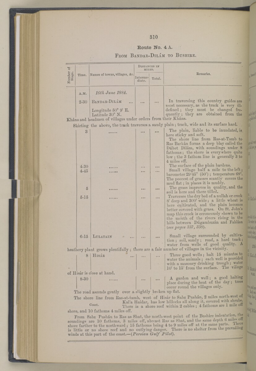
310
Houte No. 4 A.
F rom B andae -D ilam to B ushire.
UM
o
fH •
D istakces iit
miles.
CJ <u
,0 be
p c /2
£
Time.
Names of towns, villages, &e.
Interme
diate.
Total.
Remarks.
a.m.
2-30
IGtJi June 1884,
Bandae-D il I m
Longitude 50° 9 f E.
Latitude 30° N.
In traversing this country guides are
most necessary, as ihe track is very ill-
defined ; they must be changed fre
quently ; they are obtained, from the
4-30
4-45
Khans and. headmen of villages under orders from their Khans.
Skirting the above, the track traverses a sandy plain ; track, wide and its surface hard. .
3 1 ... ... The plain, liable to be inundated, is
here sticky and soft.
The shore line from Eas-at-Tamb to
Ras Bark an forms, a deep blay called the
Duhet Dilam, with soundings under 8
fathoms; the shore is everywhere quite
low ; the 3 fathom line is generally 8 to
4 miles off.
The surface of the plain hardens.
Small village half a mile to the left;
barometer 29-45" (50') ; temperature 68°.
The poorest of grasses scantly covers the
mud flat; in places it is muddy.
The grass improves in quality, and the
soil is here and there tilled.
Traverses the dry bed of a nnllah or creek
8' deep and. 300' wide ; a little wheat is
here cultivated, and the plain becomes
better covered with grass. On St. John's
map this creek is erroneously shown to be
the mouth of the rivers rising in the
hills between Diigambuzan and Fahlian
[see pages 337, 338).
5-15
6-15
L ulatain
heathery plant grows plentifully ;
Hisae
Small village surrounded
by cultiva
tion ; soil, sandy ; road, a hard _ track;
water from wells of good quality. A
tliere are a fair number of villages in the vicinity.
Three good wells ; halt 15 minutes to
water the animals ; each well is provided
with a masonry drinking trough ; water
10' to 15' from the surface. The village
of Hisar is close at hand.
8-30 ... ... A garden and well; a good halting
place during the heat of the day ; trees
occur round the villages only.
The road ascends gently over a slightly broken up flat.
The shore line from Ras-at-tamb, west of Hisar to Sabz Pushan, 2 miles north -west of
Kal'a Haidar, has low hillocks all along it, covered with shrubs.
Coast * There is a shore reef within 2 cables ; 4 fathoms are 1 mile oil
shore, and 10 fathoms 4 miles off.
From Sabz Puslian to Eas as Shat, the north-west point of the Bushire indentation, the
soundings are 10 fathoms, 3 miles off, abreast Eas as Shat, and the same depth 6 Allies o
shore farther to the northward ; 15 fathoms being 4 to 9 miles off at the same P 8,1 ^ 8, . 1 . ei ®
is little or no shore reef and no outlying danger. There is no shelter from the prevai mg
winds at this part of the coast.— (Persian G-ulf Pilot).
C«!t,
حول هذه المادة
- المحتوى
قرير عسكري عن جنوب غرب بلاد فارس، يتضمن أقاليم خوزستان (عربستان)، لورستان، وجزءًا من فارس بقلم الرائد والبارونيت. المقدم مارك س. بيل، وسام صليب فيكتوريا، فيلق المهندسين الملكي.
بيانات النشر: شيملا: مطبعة الفرع المركزي للحكومة، ١٨٨٥. أُعد في فرع الاستخبارات لإدارة قائد الإمداد والتموين في الهند.
الوصف المادي: ٣ خرائط في جيوب في النهاية. ٤١ لوحة.
- الشكل والحيّز
- مجلد واحد (٣٩٠ صفحة)
- الترتيب
يحتوي هذا المجلد على فهرس محتويات يشمل عناوين الفصول ومراجع الصفحات.
- الخصائص المادية
الأبعاد: ٢٤٥ مم × ١٥٠ مم
- لغة الكتابة
- الإنجليزية بالأحرف اللاتينية للاطّلاع على المعلومات الكاملة لهذا السجل
استخدام وإعادة نشر هذه المادة
- إعادة نشر هذه المادة
"تقرير عسكري عن جنوب غرب بلاد فارس، يتضمن أقاليم خوزستان (عربستان)، لورستان، وجزءًا من فارس" [٣١٠] (٤٦٦/٣٥٥)و المكتبة البريطانية: مجموعات مطبوعةو V 8685و مكتبة قطر الرقمية <https://www.qdl.qa/archive/81055/vdc_100023694940.0x00009a> [تم الوصول إليها في ١٠ May ٢٠٢٤]
https://www.qdl.qa/العربية/archive/81055/vdc_100023694940.0x00009a
يمكنك نسخ ولصق الفقرة التالية لتضمين الصورة في صفحة الويب الخاصة بك.
<meta charset="utf-8"><a href="https://www.qdl.qa/العربية/archive/81055/vdc_100023694940.0x00009a">"تقرير عسكري عن جنوب غرب بلاد فارس، يتضمن أقاليم خوزستان (عربستان)، لورستان، وجزءًا من فارس" [<span dir="ltr">٣١٠</span>] (٤٦٦/٣٥٥)</a> <a href="https://www.qdl.qa/العربية/archive/81055/vdc_100023694940.0x00009a"> <img src="https://iiif.qdl.qa/iiif/images/81055/vdc_100023517327.0x000001/V 8685_0383.jp2/full/!280,240/0/default.jpg" alt="" /> </a>
هذا التسجيل IIIF له ملف ظاهر متوفر كما يلي. إذا كان لديك عارض متوافق للصور يمكنك سحب الأيقونة لتحميله.https://www.qdl.qa/العربية/iiif/81055/vdc_100023517327.0x000001/manifestافتح في المتصفح العامافتح في عارض IIIF ميرادورطرق إضافية لاستخدام صور الأرشيف الرقمي
حقوق النسخ والتأليف: كيفية استخدام هذا المحتوى
- رقم الاستدعاء
- V 8685
- العنوان
- "تقرير عسكري عن جنوب غرب بلاد فارس، يتضمن أقاليم خوزستان (عربستان)، لورستان، وجزءًا من فارس"
- الصفحات
- داخلي-خلفي ،٢:١ ،ظ-iv:و-iii ،١٠:١ ،٣٩٠:٣٦٧ ،ن٣٦٦:أ٣٦٦ ،٣٦٦:٣٣٥ ،ب٣٣٤:أ٣٣٤ ،٣٣٤:٢٧٣ ،د٢٧٢:أ٢٧٢ ،٢٧٢:٢٧١ ،ب٢٧٠:أ٢٧٠ ،٢٧٠:٢٦٥ ،ب٢٦٤:أ٢٦٤ ،٢٦٤:٢٥٥ ،ب٢٥٤:أ٢٥٤ ،٢٥٤:٢٥٣ ،ب٢٥٢:أ٢٥٢ ،٢٥٢:٢٤٩ ،ب٢٤٨:أ٢٤٨ ،٢٤٨:٢٤٧ ،ب٢٤٦:أ٢٤٦ ،٢٤٦:٢٤٥ ،د٢٤٤:أ٢٤٤ ،٢٤٤:٢٤١ ،ب٢٤٠:أ٢٤٠ ،٢٤٠:٢٣٧ ،ب٢٣٦:أ٢٣٦ ،٢٣٦:٢٣١ ،ب٢٣٠:أ٢٣٠ ،٢٣٠:٢١٣ ،ب٢١٢:أ٢١٢ ،٢١٢:٢١١ ،ب٢١٠:أ٢١٠ ،٢١٠:٢٠٩ ،د٢٠٨:أ٢٠٨ ،٢٠٨:٢٠٥ ،ب٢٠٤:أ٢٠٤ ،٢٠٤:١٩٣ ،ب١٩٢:أ١٩٢ ،١٩٢:١٩١ ،د١٩٠:أ١٩٠ ،١٩٠:١٨٥ ،ب١٨٤:أ١٨٤ ،١٨٤:١٧٩ ،ب١٧٨:أ١٧٨ ،١٧٨:١٧٧ ،ب١٧٦:أ١٧٦ ،١٧٦:١٦٧ ،ب١١٦:أ١١٦ ،١١٦:١١٣ ،ب١١٢:أ١١٢ ،١١٢:١٠٩ ،ب١٠٨:أ١٠٨ ،١٠٨:٩٩ ،ب٩٨:أ٩٨ ،٩٨:٩٧ ،ب٩٦:أ٩٦ ،٩٦:٦٥ ،ب٦٤:أ٦٤ ،٦٤:٦١ ،ب٦٠:أ٦٠ ،٦٠:٥٥ ،ب٥٤:أ٥٤ ،٥٤:٤١ ،ب٤٠:أ٤٠ ،٤٠:٥ ،ب٤:أ٤ ،٤:٣ ،ب٢:أ٢ ،٢:١ ،٨:١ ،ظ-ii:و-i ،٤:١ ،داخلي-أمامي ،ذيل ،رأس ،حافة ،صلب ،خلفي ،أمامي
- المؤلف
- Bell, Mark Sever
- شروط الاستخدام
- نطاق عام