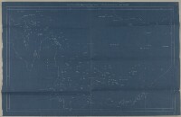
'CHART SHOWING PEARL BANKS ALONG ARABIAN SHORE OF THE PERSIAN GULF BETWEEN RAS TANURA AND DABAI'
IOR/R/15/1/616, f 5
2 items in this record
Search within this record
The record is made up of 1 map. It was created in c 1939. It was written in English. The original is part of the British Library: India Office The department of the British Government to which the Government of India reported between 1858 and 1947. The successor to the Court of Directors. Records and Private Papers Documents collected in a private capacity. .
About this record
- Content
Distinctive Features:
Blueprint showing the locations of pearling banks on the Trucial Coast A name used by Britain from the nineteenth century to 1971 to refer to the present-day United Arab Emirates. indicated by numbered small circles with a dot in centre.
- Extent and format
- 1 map
- Area map covers
- Map loading...
- Scale
- Scale not given
- Scale designator
- Horizontal
- Orientation
- North
- Degree coordinates
- Top-left: 26° 53' 28.68" N, 49° 52' 0.84" E
Top-right: 26° 53' 28.68" N, 55° 19' 5.88" E
Bottom-left: 23° 58' 7.32" N, 49° 52' 0.84" E
Bottom-right: 23° 58' 7.32" N, 55° 19' 5.88" E - It is part of
- 166 imagesRef: IOR/R/15/1/616
- Physical characteristics
Dimensions:
363 x 588 mm, on sheet 418 x 650 mm
- Written in
- English in Latin script
- Type
- Map
Archive information for this record
- Original held at
- British Library: India Office The department of the British Government to which the Government of India reported between 1858 and 1947. The successor to the Court of Directors. Records and Private Papers Documents collected in a private capacity.
- Access conditions
Unrestricted
- Archive reference
- IOR/R/15/1/616, f 5
- Date(s)
- c 1939 (CE, Gregorian)
Access & Reference
History of this record
Related search terms
- Places
- Persian Gulf
Use and share this record
- Share this record
- Cite this record in your research
'CHART SHOWING PEARL BANKS ALONG ARABIAN SHORE OF THE PERSIAN GULF BETWEEN RAS TANURA AND DABAI', British Library: India Office Records and Private Papers, IOR/R/15/1/616, f 5, in Qatar Digital Library <https://www.qdl.qa/archive/81055/vdc_100023720880.0x000002> [accessed 15 July 2026]
- Link to this record
https://www.qdl.qa/en/archive/81055/vdc_100023720880.0x000002
- IIIF details
This record has a IIIF manifest available as follows. If you have a compatible viewer you can drag the icon to load it.https://www.qdl.qa/en/iiif/81055/vdc_100000000193.0x00024d/manifestOpen in Universal viewerOpen in Mirador viewerMore options for embedding images
Copyright: How to use this content
- Reference
- IOR/R/15/1/616, f 5
- Title
- 'CHART SHOWING PEARL BANKS ALONG ARABIAN SHORE OF THE PERSIAN GULF BETWEEN RAS TANURA AND DABAI'
- Pages
- 5r:5v
- Author
- Unknown
- Usage terms
- The copyright status is unknown. Please contact [email protected] with any information you have regarding this item.