
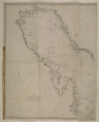
Chart of the Gulf of Persia. Constructed from the Trigonometrical Surveys Made by Order of The Hon.ble the Court of Directors of the United English East India Company; by George Barnes Brucks, Commander H.C. Marine
Mss Eur F126/96

4 items in this record
Search within this record
The record is made up of 1 map. It was created in 1832. It was written in English and Arabic. The original is part of the British Library: India Office The department of the British Government to which the Government of India reported between 1858 and 1947. The successor to the Court of Directors. Records and Private Papers Documents collected in a private capacity. .
About this record
- Content
Distinctive Features:
General chart of the Persian Gulf The historical term used to describe the body of water between the Arabian Peninsula and Iran. published in 1832 by James Horsburgh and engraved by Richard Bateman. The western sheet only, lacking the title and publisher’s details.
Relief in hachures Lines drawn on a map to indicate the direction and steepness of slope. . Depth shown by soundings Measurements of the depth of a body of water. .
Nautical chart of the Persian Gulf The historical term used to describe the body of water between the Arabian Peninsula and Iran. compiled from the surveys carried out by the Bombay Marine’s officers between 1820 and 1829, with place names inserted in both English and Arabic.
Gives detailed information on the coastline and waters of the Persian Gulf The historical term used to describe the body of water between the Arabian Peninsula and Iran. , including documenting pearl banks, rock banks, shoals and shallows. A memorandum is included in the bottom right corner of the map giving the surveys which it is based upon:
'The coast from Ras Moosenden [Musandam] to Abothubbee [Abu Dhabi] was Surveyed by Lieuts J M Guy, G B Brucks and R Cogan in 1821 and 1822; from Abothubbee to Cape, or Ras Reccan, by Lieuts J M Guy and G B Brucks in 1823 and 1824; from the latter point to Core Abdullah by Lieuts Guy, Brucks and W E Rogers, in 1824 and 1825,- from Ras Tuloop to Bushire, in 1825-26, and the remainder of Coast, Islands etc by Lieuts G B Brucks and S B Haines from 1826 to 1829.'
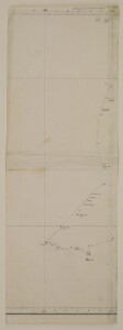
The map has been annotated with a red line to show the direction which Lewis Pelly travelled on leaving Koyt [Kuwait] for Riyadh and the direction he returned from to Bahrein [Bahrain] as well as the route that the H.M.S. "Berenice" BM took from Koyt to Bahrein to meet Lewis Pelly on his return. The top right hand corner of the map sheet contains a pencil annotation giving the longitude and latitude coordinates for Riyath [Riyadh]. Lewis Pelly departed from Kuwait in February 1865 and reached Bahrain in March 1865 and the annotations were made to the map sometime afterwards.
- Extent and format
- 1 map
- Area map covers
- Map loading...
- Scale
- Scale not given
- Scale designator
- Horizontal
- Orientation
- North
- Degree coordinates
- Top-left: 30° 31' 40.08" N, 47° 19' 29.64" E
Top-right: 30° 31' 40.08" N, 51° 47' 42.72" E
Bottom-left: 24° 0' 7.92" N, 47° 19' 29.64" E
Bottom-right: 24° 0' 7.92" N, 51° 47' 42.72" E - Physical characteristics
Dimensions: 728 x 522 mm; on sheet 770 x 610 mm
Condition: There are some small tears in the centre of the map where it has been folded and a stain mark along the bottom half of the left hand border of the map.
Foliation: The map has been foliated in the top right hand corner of the folio with a pencil number enclosed in a circle.
- Written in
- English and Arabic in Latin and Arabic script
- Type
- Map
Archive information for this record
- Original held at
- British Library: India Office The department of the British Government to which the Government of India reported between 1858 and 1947. The successor to the Court of Directors. Records and Private Papers Documents collected in a private capacity.
- Access conditions
Unrestricted
- Archive reference
- Mss Eur F126/96
- Date(s)
- 1832 (CE, Gregorian)
Access & Reference
History of this record
Related search terms
- People & organisations
- Richard BatemanGeorge Edward BrucksJames Horsburgh
Use and share this record
- Share this record
- Cite this record in your research
Chart of the Gulf of Persia. Constructed from the Trigonometrical Surveys Made by Order of The Hon.ble the Court of Directors of the United English East India Company; by George Barnes Brucks, Commander H.C. Marine, British Library: India Office Records and Private Papers, Mss Eur F126/96, in Qatar Digital Library <https://www.qdl.qa/archive/81055/vdc_100000001524.0x0003d3> [accessed 18 July 2026]
- Link to this record
https://www.qdl.qa/en/archive/81055/vdc_100000001524.0x0003d3
- IIIF details
This record has a IIIF manifest available as follows. If you have a compatible viewer you can drag the icon to load it.https://www.qdl.qa/en/iiif/81055/vdc_100000001524.0x0003d3/manifestOpen in Universal viewerOpen in Mirador viewerMore options for embedding images
Copyright: How to use this content
- Reference
- Mss Eur F126/96
- Title
- Chart of the Gulf of Persia. Constructed from the Trigonometrical Surveys Made by Order of The Hon.ble the Court of Directors of the United English East India Company; by George Barnes Brucks, Commander H.C. Marine
- Pages
- 1r:2v
- Author
- Unknown
- Usage terms
- Public Domain