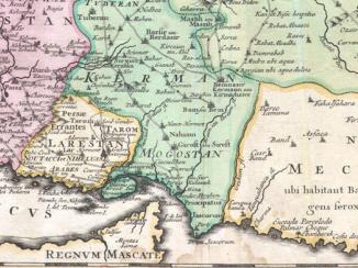
Sketch map of part of Persia
Mss Eur F126/110
2 items in this record
Search within this record
The record is made up of 1 map. It was created in c 1865. It was written in English. The original is part of the British Library: India Office The department of the British Government to which the Government of India reported between 1858 and 1947. The successor to the Court of Directors. Records and Private Papers Documents collected in a private capacity. .
About this record
- Content
Distinctive Features:
Relief shown by contours and spot heights A point on a map at which the height of the land is recorded. .
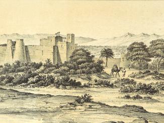
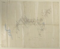
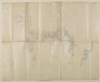
Tracing of a sketch map of Persia showing routes from Shiraz with settlements marked, including the location of Persepolis. Notations concerning the terrain features cover the face of the map; graticule A network of latitude and longitude lines. lines with degrees of latitude inserted in red ink.
Inscriptions:
On verso The back of a sheet of paper or leaf, often abbreviated to 'v'. in the bottom left-hand corner Lewis’ Pelly signature.
- Extent and format
- 1 map
- Area map covers
- Map loading...
- Scale
- Scale approximately 1:500,000
- Scale designator
- Horizontal
- Orientation
- North
- Degree coordinates
- Top-left: 30° 13' 51.6" N, 50° 46' 5.88" E
Top-right: 30° 13' 51.6" N, 53° 17' 2.4" E
Bottom-left: 28° 47' 54.6" N, 50° 46' 5.88" E
Bottom-right: 28° 47' 54.6" N, 53° 17' 2.4" E - Physical characteristics
Materials: Pen and ink with wash on tracing cloth
Dimensions: 530 x 663 mm
Foliation: The map has been foliated in the top right hand corner with a pencil number enclosed in a circle.
- Written in
- English in Latin script
- Type
- Map
Archive information for this record
- Original held at
- British Library: India Office The department of the British Government to which the Government of India reported between 1858 and 1947. The successor to the Court of Directors. Records and Private Papers Documents collected in a private capacity.
- Access conditions
Unrestricted
- Archive reference
- Mss Eur F126/110
- Date(s)
- c 1865 (CE, Gregorian)
Access & Reference
History of this record
Related search terms
- Places
- Persia
Use and share this record
- Share this record
- Cite this record in your research
Sketch map of part of Persia, British Library: India Office Records and Private Papers, Mss Eur F126/110, in Qatar Digital Library <https://www.qdl.qa/archive/81055/vdc_100000001524.0x0003e1> [accessed 29 June 2026]
- Link to this record
https://www.qdl.qa/en/archive/81055/vdc_100000001524.0x0003e1
- IIIF details
This record has a IIIF manifest available as follows. If you have a compatible viewer you can drag the icon to load it.https://www.qdl.qa/en/iiif/81055/vdc_100000001524.0x0003e1/manifestOpen in Universal viewerOpen in Mirador viewerMore options for embedding images
Copyright: How to use this content
- Reference
- Mss Eur F126/110
- Title
- Sketch map of part of Persia
- Pages
- 1r:1v
- Author
- East India Company, the Board of Control, the India Office, or other British Government Department
- Usage terms
- Open Government Licence