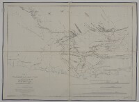
‘Map of Western Baluchistan Compiled by Order of H.M. Secretary of State for India to Show the Western Frontier of the Territories H.H. the Khan of Kalat as Determined by the Frontier Commission Under Major General Sir Frederic J. Goldsmid C.B., K.C.S.I., by Major O.B.C. [Oliver Beauchamp Coventry ] St. John R.E.’
IOR/X/3094/1-4
2 items in this record
Search within this record
The record is made up of 1 map. It was created in 1874. It was written in English. The original is part of the British Library: Map Collections.
About this record
- Content
Distinctive Features:
Relief shown by shading and spot heights. Boundary indicated by pecked line and tinted pink; unexplored areas labelled. Routes of various expeditions shown in colour with names of explorers and dates of their journeys given. Numerous notations on topographic features inserted on the map. Includes three longitudinal sections, a descriptive note on sources used in compilation of map and a key to colours.
- Extent and format
- 1 map
- Area map covers
- Map loading...
- Scale
- Scale approximately 1:500,000
- Scale designator
- Horizontal
- Orientation
- North
- Degree coordinates
- Top-left: 28° 18' 1.44" N, 57° 58' 14.52" E
Top-right: 28° 18' 1.44" N, 64° 7' 48.36" E
Bottom-left: 24° 58' 44.04" N, 57° 58' 14.52" E
Bottom-right: 24° 58' 44.04" N, 64° 7' 48.36" E - Physical characteristics
Dimensions: 914 x 1249 mm, on sheet 1008 x 1360 mm
- Written in
- English in Latin script
- Type
- Map
Archive information for this record
- Original held at
- British Library: Map Collections
- Access conditions
Unrestricted
- Archive reference
- IOR/X/3094/1-4
- Former external reference(s)
- M.IV.42
- Date(s)
- 1874 (CE, Gregorian)
Access & Reference
History of this record
Related search terms
- Places
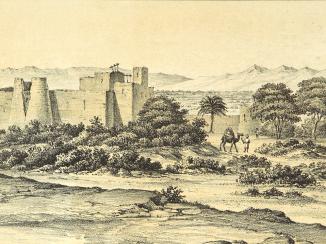
- Mekran Coast Baluchistan
- People & organisations
- Sir Knight Frederic John GoldsmidOliver Beauchamp Coventry St John
Use and share this record
- Share this record
- Cite this record in your research
‘Map of Western Baluchistan Compiled by Order of H.M. Secretary of State for India to Show the Western Frontier of the Territories H.H. the Khan of Kalat as Determined by the Frontier Commission Under Major General Sir Frederic J. Goldsmid C.B., K.C.S.I., by Major O.B.C. [Oliver Beauchamp Coventry ] St. John R.E.’, British Library: Map Collections, IOR/X/3094/1-4, in Qatar Digital Library <https://www.qdl.qa/archive/81055/vdc_100022879252.0x000001> [accessed 26 April 2024]
- Link to this record
https://www.qdl.qa/en/archive/81055/vdc_100022879252.0x000001
- IIIF details
This record has a IIIF manifest available as follows. If you have a compatible viewer you can drag the icon to load it.https://www.qdl.qa/en/iiif/81055/vdc_100022879252.0x000001/manifestOpen in Universal viewerOpen in Mirador viewerMore options for embedding images
Copyright: How to use this content
- Reference
- IOR/X/3094/1-4
- Title
- ‘Map of Western Baluchistan Compiled by Order of H.M. Secretary of State for India to Show the Western Frontier of the Territories H.H. the Khan of Kalat as Determined by the Frontier Commission Under Major General Sir Frederic J. Goldsmid C.B., K.C.S.I., by Major O.B.C. [Oliver Beauchamp Coventry ] St. John R.E.’
- Pages
- 1r:1v
- Author
- India Office
- Usage terms
- Public Domain