!['ROUTES IN PERSIA, Section 1.' [‎106r] (216/416)](https://iiif.qdl.qa/iiif/images/81055/vdc_100000001491.0x000111/Mss Eur F111_369_0216.jp2/full/!1200,1200/0/default.jpg "'ROUTES IN PERSIA, Section 1.' [‎106r] (216/416)")
'ROUTES IN PERSIA, Section 1.' [106r] (216/416)
The record is made up of 1 volume (206 folios). It was created in 1898. It was written in English. The original is part of the British Library: India Office The department of the British Government to which the Government of India reported between 1858 and 1947. The successor to the Court of Directors. Records and Private Papers Documents collected in a private capacity. .
Transcription
This transcription is created automatically. It may contain errors.
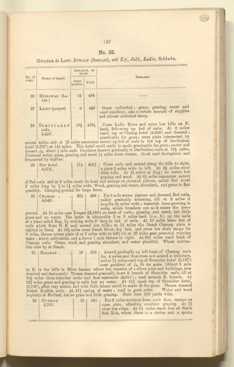
167
No. 33.
Gvvadar to Lash Juwain (Sistan), via Eej, Jalk , Ladis, SeJikuha.
No. of
Btage.
Names of stages.
Distancb, in
MILES.
Inter
mediate.
Total.
Remarks.
26
Mibzawar (La-
12
434
DI8.)
27
Ladis (proper)
8
442
28
Daribiaban
16g
HlCS
00
to
nala .
5,416'.
Grass unlimited ; grass, grazing, water and
wood excellent, also a certain amount of supplies
and almost unlimited sheep.
Cross Ladis River and enter low hills on N.
bank, following up bed of nala . At 6 miles
reach top of Chedag Icotoil (djOdS’) and descend;
practicable for guns; cross plain intersected by
several ncuas , ana at ijs mnes commence ascent up bed of nala to the top of Davibiaban
Icotal (5,797 ; ) at 14| miles. This Icotal could easily be made practicable for guns; ascent and
descent about
| J mile each. Continue descent gradually to Daribiaban ttala at 16| miles.
Perennia~fwater, grass, grazing and wood 1| miles down stream. Good road throughout and
frequented by kajilas .
29
Bed total.
6,674'.
m
469|
Cross nala and ascend along the hills to right,
a plain 5 miles wide to left. At 3^ miles enter
shale hills. At 4f arrive at Bug; no water, but
grazing and wood. At 6| miles commence ascent
of Bed nala and at 9 miles reach its head and emerge on elevated plateau, called Bed ^ kotal
2 miles long by to lg miles wide. Wood, grazing and water, abundant, and grass in fair
quantity. Camping ground for large force.
Fori mile across plateau and descend Bed nala ,
valley gradually widening, till at 2 miles it
is quite 3g miles wide ; tamarisk trees growing in
nala , which broadens out as it enters the lower
Kosgar (5,189') on bank of nala -, grazing and wood, but little
grass and no water. The latter is obtainable 2 or 3 miles back { i . e ., S.) up the nala
at a place called Bug, by sinking wells 6' deep in bed of nala . At 10 miles leave bed of
nala which flows N. E. and ascend low hills; at 11 miles the Dozab Chamag plain is
sighted in front. At 13g miles cross Dozab River, dry bed, and cross low shale range for
3 miles, thence across plain (6 or 7 miles wide to left) till at 27 miles pass perennial running
water; wheat cultivation, and a karez 1 mile distant to right. At 28|^ miles reach bank of
Chamag nala . Grass, wood, and grazing abundant, and water plentiful. Wheat cultiva
tion close by at Dozab.
30
Chamag. .
28|
498
4,549'.
ground. At 10 miles pass
31
Malikaf
18
516
Ascend gradually up left bank of Chamag nala
for 4 miles and then cross and ascend a tributary,
and at 7| miles reach top of Shemidar kotal (5,187')
easy gradient of fit f° r guns. (About 1 mile
to E. in the hills is Mina bazaar, where are remains of a silver mine and buildings, now
deserted and destroyed.) Thence descend gradually down S. branch of Shemidar nala , till at
10J miles three branches unite and flow eastwards (4,681'); road ascends N. branch. At
12| miles grass and grazing in but no water. At 13f reach top of Shemidar kotal ,
(5,103'), after easy ascent, and with little labour could be made fit for guns. Thence descend
Habsh Kushta nala . At 17i spring of water ; road in good order. Water and wood
Hala here 100 yards wide.
32
Hubmak
2,761'.
15
531
For 2 miles continue down nala then emerge on
open plain, affording excellent grazing. At 3|
cross low ridge. At 6g miles reach foot of Malik
Siah Kuh, where there is a shrine and a spring
About this item
- Content
The publication, Routes in Persia, Section I was compiled in the Intelligence Branch of the Quarter-Master Gerneral's Department in India and was published by the Office of the Superintendent of Government Printing, India, Calcutta: 1898.
Section I contains all the routes which commence from the Persian Gulf The historical term used to describe the body of water between the Arabian Peninsula and Iran. littoral and extending to a line drawn from Burajird [Borūjerd], through Isfahan [Eşfahān], Yazd, Karman [Kermān], Khabis [Khabīş], Neh to Lash Juwain [Lāsh-e Juwayn]; the routes have been arranged within the volume by starting from the sea base of the Persian Gulf The historical term used to describe the body of water between the Arabian Peninsula and Iran. and working up towards the line described.
For each route described the previous authorities, such as publications and accounts of journeys, are given, along with the following details:
- Names of stages: towns and villages which act as stopping points along the route;
- The distance in miles from the previous stage of the route;
- The total distance in miles for that route up to that stage;
- Remarks: including geographical information; details on smaller settlements; sacred places; condition of roads; access to water; other roads and routes.
The volume also includes two appendices which contain details of other routes for which the information was received too late to be included in the main body of the volume.
An ink stamp on the front cover records the confidential nature of the publication and that it was being transmitted for the information of His Excellency the Viceroy (Victor Alexander Bruce, 9th Earl of Elgin and 16th Earl of Kincardine) only.
The inside front and back covers have pockets containing index maps of the routes described in the volume.
- Extent and format
- 1 volume (206 folios)
- Arrangement
Folios 6-10 consist of an alphabetical index to names of places featured in the volume, excluding those places which appear in appendix II. Folios 11-17 are an alphabetical cross-index of the routes featured in the volume, again excluding those routes which appear in appendix II.
- Physical characteristics
Foliation: The foliation sequence commences at the front cover, and terminates at the inside back cover; these numbers are written in pencil, are circled, and are located in the top right corner of the recto The front of a sheet of paper or leaf, often abbreviated to 'r'. side of each folio. The volume aso contains an original printed pagination sequence.
- Written in
- English in Latin script View the complete information for this record
Use and share this item
- Share this item
'ROUTES IN PERSIA, Section 1.' [106r] (216/416), British Library: India Office Records and Private Papers, Mss Eur F111/369, in Qatar Digital Library <https://www.qdl.qa/archive/81055/vdc_100025705311.0x000011> [accessed 26 April 2024]
https://www.qdl.qa/en/archive/81055/vdc_100025705311.0x000011
Copy and paste the code below into your web page where you would like to embed the image.
<meta charset="utf-8"><a href="https://www.qdl.qa/en/archive/81055/vdc_100025705311.0x000011">'ROUTES IN PERSIA, Section 1.' [‎106r] (216/416)</a> <a href="https://www.qdl.qa/en/archive/81055/vdc_100025705311.0x000011"> <img src="https://iiif.qdl.qa/iiif/images/81055/vdc_100000001491.0x000111/Mss Eur F111_369_0216.jp2/full/!280,240/0/default.jpg" alt="" /> </a>
This record has a IIIF manifest available as follows. If you have a compatible viewer you can drag the icon to load it.https://www.qdl.qa/en/iiif/81055/vdc_100000001491.0x000111/manifestOpen in Universal viewerOpen in Mirador viewerMore options for embedding images
Copyright: How to use this content
- Reference
- Mss Eur F111/369
- Title
- 'ROUTES IN PERSIA, Section 1.'
- Pages
- front, back, spine, edge, head, tail, front-i, 2r:205v, back-i
- Author
- East India Company, the Board of Control, the India Office, or other British Government Department
- Usage terms
- Open Government Licence