![Coll 6/88 'Intelligence: Military Report on Arabia (C.B. 1892).' [‎19r] (42/133)](https://iiif.qdl.qa/iiif/images/81055/vdc_100000000555.0x0002bb/IOR_L_PS_12_2160B_0043.jp2/full/!1200,1200/0/default.jpg "Coll 6/88 'Intelligence: Military Report on Arabia (C.B. 1892).' [‎19r] (42/133)")
Coll 6/88 'Intelligence: Military Report on Arabia (C.B. 1892).' [19r] (42/133)
The record is made up of 1 file (63 folios). It was created in Feb 1932-7 Feb 1942. It was written in English. The original is part of the British Library: India Office The department of the British Government to which the Government of India reported between 1858 and 1947. The successor to the Court of Directors. Records and Private Papers Documents collected in a private capacity. .
Transcription
This transcription is created automatically. It may contain errors.
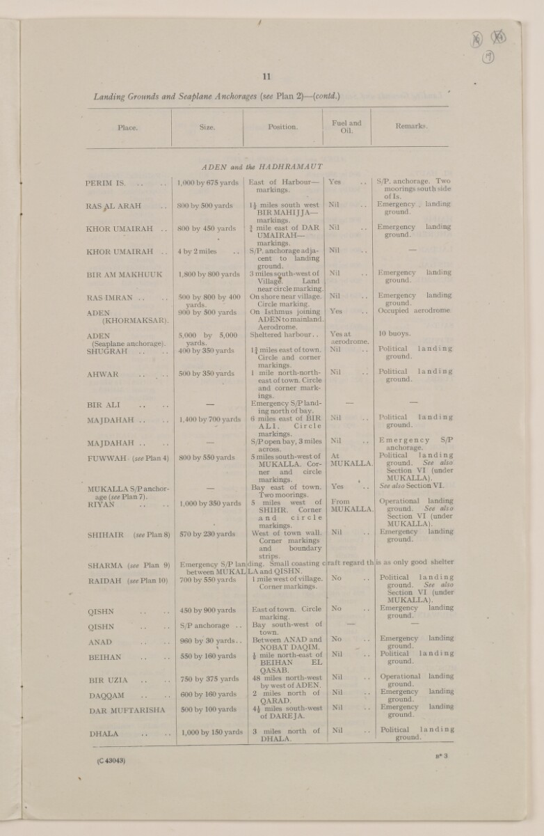
11
/
Landing Grounds and Seaplane Anchorages [see Plan 2)— [contd.)
Place.
Size.
Position.
Fuel and
Oil.
Remarks.
ADEN and the HADHRAMAUT
PERIM IS
1,000 by 675 yards
East of Harbour—
Yes
markings.
RAS AL ARAH
800 by 500 yards
1^ miles south west
Nil
BIR MAHIJ JA—
markings.
Nil
KHOR UM AIR API . .
800 by 450 yards
J mile east of DAR
UMAIRAH—
markings.
KHOR UMAIRAH . .
4 by 2 miles
S/P. anchorage adja-
Nil
cent to landing
ground.
Nil
BIR AM MAKHUUK
1,800 by 800 yards
3 miles south-west of
Village. Land
near circle marking.
RASIMRAN . .
500 by 800 by 400
On shore near village.
Nil
yards.
Circle marking.
Yes
ADEN
900 by 500 yards
On Isthmus joining
(KHORMAKSAR).
ADEN to mainland.
Aerodrome.
ADEN
5,000 by 5,000
Sheltered harbour. .
Yes at
(Seaplane anchorage).
yards.
If miles east of town.
aerodrome.
SHUGRAPI . .
400 by 350 yards
Nil
Circle and corner
markings.
Nil
AH WAR
500 by 350 yards
1 mile north-north-
east of town. Circle
and corner mark-
ings.
BIR ALI
—
Emergency S/P land-
—
ing north of bay.
Nil
MAJDAHAH ..
1,400 by 700 yards
6 miles east of BIK
ALI. Circle
markings.
Nil
MAJDAHAH . .
—
S/P open bay, 3 miles
across.
FUWWAH - [see Plan 4)
800 by 550 yards
5 miles south-west of
At
MUKALLA. Cor
ner and circle
markings.
MUKALLA.
Yes
MUKALLA S/P anchor-
—
Bay east of town.
age [see Plan 7).
RIYAN
1,000 by 350 yards
Two moorings.
5 miles west of
From
SHIHR. Corner
MUKALLA.
,and circle
SHIHAIR [see Plan 8)
570 by 230 yards
markings.
West of town wall.
Nil
Corner markings
and boundary
strips.
raft regard th
SHARMA [see Plan 9)
Emergency S/P lan
ding. Small coasting c
between MUKAL
LA and QISHN.
No
RAIDAH [see Plan 10)
700 by 550 yards
1 mile west of village.
Corner markings.
QISHN
450 by 900 yards
East of town. Circle
marking.
No
QISHN . .
S/P anchorage . .
Bay south-west of
town.
ANAD
960 by 30 yards. .
Between ANAD and
No
\
NOBAT DAQIM.
-
BEIHAN
550 by 160 yards
J mile north-east of
Nil
BEIHAN EL
QASAB.
Nil
BIR UZIA
750 by 375 yards
48 miles north-west
by west of ADEN.
DAQQAM
600 by 160 yards
2 miles north of
QARAD.
Nil
DAR MUFTARISHA
500 by 100 yards
4J miles south-west
Nil
of DAREJA.
DHALA
1,000 by 150 yards
3 miles north of
Nil
DHALA.
S/P. anchorage. Two
moorings south side
of Is.
Emergency . landing
ground.
Emergency landing
ground.
Emergency landing
ground.
Emergency landing
ground.
Occupied aerodrome,
10 buoys.
Political landing
ground.
Political landing
ground.
Political landing
ground.
Emergency S/P
anchorage.
Political landing
ground. See also
Section YI (under
MUKALLA).
See also Section VI.
Operational landing
ground. See also
Section VI (under
MUKALLA).
Emergency landing
ground.
is as only good shelter
Political landing
ground. See also
Section VI (under
MUKALLA).
Emergency landing
ground.
Emergency landing
ground.
Political landing
ground.
Operational landing
ground.
Emergency landing
ground.
Emergency landing
ground.
Political landing
ground.
B* 3
(C 43043)
About this item
- Content
This file consists of two parts. The first part (folios 1-9) begins with a 'state of report' document for an Admiralty Naval Intelligence Division report entitled 'Arabia, Intelligence Report'; the 'state report' concerns the updating of the report in October 1941, and it includes a list of maps, plans and photographs that are contained in the report. There then follows a small amount of correspondence between India Office The department of the British Government to which the Government of India reported between 1858 and 1947. The successor to the Court of Directors. , War Office, and General Staff (India) officials regarding the supply of an earlier issue of the report, dated 1939.
The second part of the file consists of the actual report, entitled 'C.B. 1892 (X) (10/41) Arabia Intelligence Report', dated October 1941, with appended maps, plans and photographs relating to Arabian Peninsula ports. The report is divided into four sections (six sections are listed in the table of contents, which lists sections one and three, most of section two, and one part of section five, as 'not issued', i.e. not printed in this edition of the report).
The first section to appear in the report is entitled 'Section II: Strategy and Tactics'; parts 1 and 3-6 of this section have been omitted, leaving part 2, which has the heading 'Possible Lines on which War Plans would be Framed'.
The next section, 'Section IV: Geography and Topography', provides an overview of the geography and topography of the Arabian Peninsula, including information about climate, transport facilities (including a table of landing grounds and seaplane anchorages), and communications.
The third section, 'Section V: Base Facilities and Maintenance of the Fleet' (from which part one has been omitted), provides a summary of principal commercial dockyards and repair bases, locations for fuel storage, supplies and storage of ammunition, fixed coastal defences, and aircraft.
The final section of the report, 'Section VI: Ports, Anchorages and Their Defences', proceeds through a number of Gulf ports in alphabetical order (i.e. Akaba, Bahrain, Doha, Hodeida and Ras Kethib, Jedda, Kamaran, Kuwait, Mukalla, and Muscat), describing each place's port facilities, anchorages and defences, as well as providing other information relating to matters such as government, commerce, water supply, transport and communications.
Enclosed with the maps and plans is a symbols chart, which lists some of the symbols used in the maps and plans.
- Extent and format
- 1 file (63 folios)
- Arrangement
The Arabia Intelligence Report contains a table of contents. The maps, plans and photographs, which are listed below the table of contents, appear after the main text of the report.
- Physical characteristics
Foliation: The file is formed of two parts. The foliation sequence (used for referencing) commences at the front cover of the first part at 1 and terminates at the inside back cover of the second part at 65; these numbers are written in pencil, are circled, and are located in the top right corner of the recto The front of a sheet of paper or leaf, often abbreviated to 'r'. side of each folio.
- Written in
- English in Latin script View the complete information for this record
Use and share this item
- Share this item
Coll 6/88 'Intelligence: Military Report on Arabia (C.B. 1892).' [19r] (42/133), British Library: India Office Records and Private Papers, IOR/L/PS/12/2160B, in Qatar Digital Library <https://www.qdl.qa/archive/81055/vdc_100043097172.0x00002b> [accessed 14 July 2026]
https://www.qdl.qa/en/archive/81055/vdc_100043097172.0x00002b
Copy and paste the code below into your web page where you would like to embed the image.
<meta charset="utf-8"><a href="https://www.qdl.qa/en/archive/81055/vdc_100043097172.0x00002b">Coll 6/88 'Intelligence: Military Report on Arabia (C.B. 1892).' [‎19r] (42/133)</a> <a href="https://www.qdl.qa/en/archive/81055/vdc_100043097172.0x00002b"> <img src="https://iiif.qdl.qa/iiif/images/81055/vdc_100000000555.0x0002bb/IOR_L_PS_12_2160B_0043.jp2/full/!280,240/0/default.jpg" alt="" /> </a>
This record has a IIIF manifest available as follows. If you have a compatible viewer you can drag the icon to load it.https://www.qdl.qa/en/iiif/81055/vdc_100000000555.0x0002bb/manifestOpen in Universal viewerOpen in Mirador viewerMore options for embedding images
Copyright: How to use this content
- Reference
- IOR/L/PS/12/2160B
- Title
- Coll 6/88 'Intelligence: Military Report on Arabia (C.B. 1892).'
- Pages
- front, front-i, 2r:9v, front-a, back, spine, edge, head, tail, front-a-i, 11r:39v
- Author
- East India Company, the Board of Control, the India Office, or other British Government Department
- Usage terms
- Open Government Licence