'PLANS IN THE PERSIAN GULF. BAHREIN HARBOUR'
IOR/L/PS/10/169, f 324

2 items in this record
Search within this record
The record is made up of 1 map. It was created in 1903-1911. It was written in English. The original is part of the British Library: India Office The department of the British Government to which the Government of India reported between 1858 and 1947. The successor to the Court of Directors. Records and Private Papers Documents collected in a private capacity. .
About this record
- Content
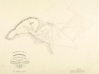
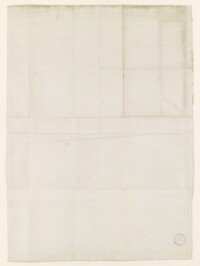
A map indicating the locations of one buoy and one stone beacon in Bahrein Harbour in the Persian Gulf The historical term used to describe the body of water between the Arabian Peninsula and Iran. . The buoy and beacon are marked in manuscript with corresponding arrows drawn in the right margin.
The base map on which the buoys are indicated is Admiralty chart 3380, 'Published at the Admiralty, 2nd. Octr. 1903'.
A hand stamp on the verso The back of a sheet of paper or leaf, often abbreviated to 'v'. reads, 'British India Steam Navigation Co. Ltd. Received 19 Aug. 1908'.
- Extent and format
- 1 map
- Area map covers
- Map loading...
- Scale
- Scale 1:24,350
- Scale designator
- Horizontal
- Orientation
- North
- Degree coordinates
- Top-left: 26° 19' 41.88" N, 50° 30' 0" E
Top-right: 26° 19' 41.88" N, 50° 38' 24.36" E
Bottom-left: 26° 12' 38.52" N, 50° 30' 0" E
Bottom-right: 26° 12' 38.52" N, 50° 38' 24.36" E - It is part of
- 660 imagesRef: IOR/L/PS/10/169
- Physical characteristics
Materials: Printed on paper with manuscript additions in coloured ink
Dimensions: 465 x 470mm, on sheet 685 x 490mm
- Written in
- English in Latin script
- Type
- Map
Archive information for this record
- Original held at
- British Library: India Office The department of the British Government to which the Government of India reported between 1858 and 1947. The successor to the Court of Directors. Records and Private Papers Documents collected in a private capacity.
- Access conditions
Unrestricted
- Archive reference
- IOR/L/PS/10/169, f 324
- Date(s)
- 1903-1911 (CE, Gregorian)
- Related primary sources
Further copies of the base map are held in the British Library at shelfmark: Maps SEC.12.(3380.)
Access & Reference
History of this record
Related material
Related search terms
- Places
- Persian GulfBahrein
- People & organisations
- Admiralty
Use and share this record
- Share this record
- Cite this record in your research
'PLANS IN THE PERSIAN GULF. BAHREIN HARBOUR', British Library: India Office Records and Private Papers, IOR/L/PS/10/169, f 324, in Qatar Digital Library <https://www.qdl.qa/archive/81055/vdc_100077200285.0x000005> [accessed 19 April 2024]
- Link to this record
https://www.qdl.qa/en/archive/81055/vdc_100077200285.0x000005
- IIIF details
This record has a IIIF manifest available as follows. If you have a compatible viewer you can drag the icon to load it.https://www.qdl.qa/en/iiif/81055/vdc_100000000419.0x00003e/manifestOpen in Universal viewerOpen in Mirador viewerMore options for embedding images
Copyright: How to use this content
- Reference
- IOR/L/PS/10/169, f 324
- Title
- 'PLANS IN THE PERSIAN GULF. BAHREIN HARBOUR'
- Pages
- 324r:324v
- Author
- East India Company, the Board of Control, the India Office, or other British Government Department
- Usage terms
- Open Government Licence