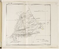
Map showing part of the Perso-Baluchistan frontier
IOR/L/PS/12/3425, f 55
2 items in this record
Search within this record
The record is made up of 1 map. It was created in 1895. It was written in English. The original is part of the British Library: India Office The department of the British Government to which the Government of India reported between 1858 and 1947. The successor to the Court of Directors. Records and Private Papers Documents collected in a private capacity. .
About this record
- Content
Map of part of the frontier between Persia [Iran] and Baluchistan [in present-day Pakistan]. The map was surveyed by Jamaluddin, sub-surveyor, and Lieutenant-Colonel R A Wahab, Survey Officer, of the Perso-Baluch Boundary Commission, and is dated 1 May 1895. The map indicates: the boundary, marked as a thick dashed black line; hydrology; topography, with some indication of relief; settlements. Small areas on the map, demarcated by dotted lines, are coloured yellow. At the top of the map is the statement ‘Memo. B.’ Printing statements in the bottom right of the map read: ‘Litho. S.I.O., Calcutta [Kolkata].’ and ‘Heliozincographed at the Survey of India Offices, Calcutta.’
- Extent and format
- 1 map
- Area map covers
- Map loading...
- Scale
- 1:253,440
- Scale designator
- Horizontal
- Orientation
- North
- Degree coordinates
- Top-left: 27° 15' 34.25" N, 63° 10' 16.99" E
Top-right: 27° 15' 34.25" N, 63° 45' 23.07" E
Bottom-left: 26° 39' 8.52" N, 63° 10' 16.99" E
Bottom-right: 26° 39' 8.52" N, 63° 45' 23.07" E - It is part of
- 658 imagesRef: IOR/L/PS/12/3425
- Physical characteristics
Dimensions: 290 x 320 mm, on sheet 333 x 420 mm.
Materials: printed on paper.
- Written in
- English in Latin script
- Type
- Map
Archive information for this record
- Original held at
- British Library: India Office The department of the British Government to which the Government of India reported between 1858 and 1947. The successor to the Court of Directors. Records and Private Papers Documents collected in a private capacity.
- Access conditions
Unrestricted
- Archive reference
- IOR/L/PS/12/3425, f 55
- Former external reference(s)
- Reg. No. 32C., F.O.-Nov. 96.-21. Reg No. 2955. E. 32.-50.
- Date(s)
- 1895 (CE, Gregorian)
Access & Reference
History of this record
Related search terms
Use and share this record
- Share this record
- Cite this record in your research
Map showing part of the Perso-Baluchistan frontier, British Library: India Office Records and Private Papers, IOR/L/PS/12/3425, f 55, in Qatar Digital Library <https://www.qdl.qa/mirador/81055/vdc_100085085664.0x000002> [accessed 25 June 2026]
- Link to this record
https://www.qdl.qa/en/archive/81055/vdc_100085085664.0x000002
- IIIF details
This record has a IIIF manifest available as follows. If you have a compatible viewer you can drag the icon to load it.https://www.qdl.qa/en/iiif/81055/vdc_100000000602.0x0003d2/manifestOpen in Universal viewerOpen in Mirador viewerMore options for embedding images
Copyright: How to use this content
- Reference
- IOR/L/PS/12/3425, f 55
- Title
- Map showing part of the Perso-Baluchistan frontier
- Pages
- 55r:55v
- Author
- East India Company, the Board of Control, the India Office, or other British Government Department
- Usage terms
- Open Government Licence