!["تقرير عسكري عن جنوب غرب بلاد فارس، بما في ذلك أقاليم خوزستان (عربستان)، لورستان، وجزء من فارس" [<span dir="ltr">ظ١٦٤</span>] (٤٧٠/٣٣٣)](https://iiif.qdl.qa/iiif/images/81055/vdc_100000000239.0x00012f/IOR_L_MIL_17_15_9_0363.jp2/full/!1200,1200/0/default.jpg "\"تقرير عسكري عن جنوب غرب بلاد فارس، بما في ذلك أقاليم خوزستان (عربستان)، لورستان، وجزء من فارس\" [<span dir=\"ltr\">ظ١٦٤</span>] (٤٧٠/٣٣٣)")
"تقرير عسكري عن جنوب غرب بلاد فارس، بما في ذلك أقاليم خوزستان (عربستان)، لورستان، وجزء من فارس" [ظ١٦٤] (٤٧٠/٣٣٣)
محتويات السجل: مجلد واحد (٢٣١ ورقة). يعود تاريخه إلى ١٨٨٥. اللغة أو اللغات المستخدمة: الإنجليزية. النسخة الأصلية محفوظة في المكتبة البريطانية: أوراق خاصة وثائق جُمعت بصفة شخصية. وسجلات من مكتب الهند إدارة الحكومة البريطانية التي كانت الحكومة في الهند ترفع إليها تقاريرها بين عامي ١٨٥٨ و١٩٤٧، حيث خلِفت مجلس إدارة شركة الهند الشرقية. .
نسخ
النسخ مستحدث آليًا ومن المرجّح أن يحتوي على أخطاء.
■iiMiinnrr»r i irmn«w.
rnmtmm
292
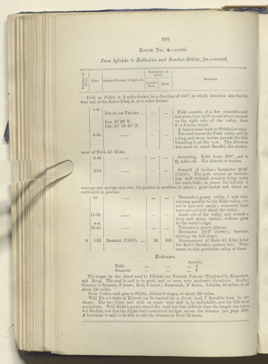
Route No. 4— contd.
From Isfahan to Behbahdn, and Bandar-Dildm,' fyc . —contd.
o
c ^
Time.
Names of towns, villages, &c.
Distances in
miles.
Kemarks.
II
>5
Interme
diate.
Total.
Feint or Pelart is 2 miles distant in a direction of 160°, in which direction also lies the
west end of the Kuh-i-Dina, 4 or 5 miles distant.
A.SI.
Felat ok Felart ...
Lon. 51°29' E.
Lat. 31° 19' 30" N.
8-50
ment of Mula AH Khan.
! 9-45
Felat consists of a few miserable mud
and stone huts built on and about amound
on the right side of the -valley, there
6 < r 8 miles broad.
A beaten road leads to Shiraz (see map).
The road leaves the Felat valley, and by
a long and steep incline ascends the hills
bounding it on the east. This diversion
was made to reach Bassaki, the encamp-
Ascending, Felat bears 200°, and is
2g miles off. The district is treeless.
10-5 ... ... Summit of incline ; barometer 2245"
(7,900'). The path crosses an undulat
ing, well watered country lying under
, the main hills ; in places the hill-side is
swampy and springs oose out; the pasture is excellent in places ; good barley and wheat are
cultivated in patches.
10
...
11-35
PM.
12-50
...
1-25
Bassaki (7,850') ...
24
1 Descends a grassy valley, 1 mile wide,
running parallel to the Felat valley ; the
! soil is open and sandy ; numerous iliyat
tents are pitched about the valley.
Leads out of the valley and ascends a
j deep and stony ravine; willows grow
by the water’s edge.
Traverses a grassy plateau.
Barometer 22’d" (8,080 ) ; descends,
skirting the hill slopes.
Encampment of Mula Ali Khan below
1 the Knh-i-Bassaki; pasture fair. Mater
I scarce in this particular valley at times.
Bistances.
Farsakhs.
Felat ... ... ... 2
Simarun ... ... ... 6
The stages by the direct road to Isfahan are Nakneh, Takoun (TarghdndP), Kumesheh,
and Marg. The road is said to be good, and to cross very moderate elevations. Another
itinerary is Simarun, 8 hours; Kori, 6 hours ; Kumesheh, 8 hours ; Isfahan, 46 miles; in all
about 120 miles.
From Felat a road goes to Shiraz, distant 8 stages, or about 160 miles.
Wall Khan’s tents at Khurra can be reached by a direct road. 7 farsakhs long:, in two
stages. The two rivers met with en route were said to be unfordable, and the hills most
precipitous. Wall Khan’s people stated the road was less difficult than the longer one taken
e/d Sisakht, and that the iliyats had constructed bridges across the streams (see page 300).
A horseman is said to be able to ride the distance in 10 to 12 hours.
حول هذه المادة
- المحتوى
تقرير موسوم بأنه سريّ للغاية، أعدّه مساعد قائد الإمداد والتموين، الرائد الحاصل على ترقية استثنائية لرتبة مقدم مارك سيفر بيل من المهندسين الملكيين، في فرع المخابرات التابع لإدارة الإمداد والتموين. نشر المجلد مطبعة الفرع المركزي للحكومة، شيملا، ١٨٨٥.
تتلخص محتويات المجلد فيما يلي:
- الجزء I، وصف سردي لرحلة من الهند إلى المحمرة [خرمشهر]، وإلى قم عبر تلال لورستان؛ من قم إلى كلبايكان، وتشمان سلطان، وأليغودرز، وإمامزاده إسماعيل، ونهر زاينده، إلى أصفهان: ومن أصفهان إلى بهبهان وبندر ديلم عبر تلال كهكيلويه؛ من بندر ديلام إلى بوشهر
- الجزء II، وصف مفصل لجنوب غرب بلاد فارس، تم جمعه من ملاحظات سيفر الخاصة وغيرها من المصادر المتاحة
- الجزء III، الاعتبارات التجارية. هناك جزء آخر في هذا الفصل بشأن الملاحظات الاستراتيجية، التي ذُكرت في صفحة المحتويات ووُسمت بأنها سرية، غير موجود في المجلد
- الجزء IV، تقارير مفصّلة عن الطرق
- الملحق خريطة صغيرة أو صورة أخرى محاطة بهامش خريطة أكبر أو خريطة مفردة أو صورة أكبر؛ أو أوراق موضوعة داخل كتاب أو مجلد أرشيفي. أ، تقارير عن الطرق، من أصفهان إلى تُستر، ومنها إلى شيراز، جمعها في سنة ١٨٨١ النقيب هنري ليك ويلز، مساعد مدير إدارة التلغراف الفارسية، مع تعليقات إضافية بقلم بيل.
- الملحق خريطة صغيرة أو صورة أخرى محاطة بهامش خريطة أكبر أو خريطة مفردة أو صورة أكبر؛ أو أوراق موضوعة داخل كتاب أو مجلد أرشيفي. ب، قائمة بعينات نباتية جُمعت في لورستان خلال شهرَي أبريل ومايو ١٨٨٤
- الملحق خريطة صغيرة أو صورة أخرى محاطة بهامش خريطة أكبر أو خريطة مفردة أو صورة أكبر؛ أو أوراق موضوعة داخل كتاب أو مجلد أرشيفي. ج، مقتطفات من مقالة عن جيولوجيا الحدود التركية-الفارسية، بقلم ويليام كينيت لوفتوس، يونيو ١٨٥٤
- الملحق خريطة صغيرة أو صورة أخرى محاطة بهامش خريطة أكبر أو خريطة مفردة أو صورة أكبر؛ أو أوراق موضوعة داخل كتاب أو مجلد أرشيفي. د، ملاحظات عن الأرصاد الجوية في بوشهر، من ٢٠ مارس إلى ٢٠ يونيو ١٨٨٥
يتضمن المجلد ثماني خرائط، ولوحتين فوتوغرافيتين، ورسوم توضيحية (طوبوغرافية، ومعمارية، وأنثروبولوجية). يعود تاريخ اللوحتين الفوتوغرافيتين وبعض الخرائط لفترة تسبق تاريخ نشر المجلد في سنة ١٨٨٥.
- الشكل والحيّز
- مجلد واحد (٢٣١ ورقة)
- الترتيب
توجد صفحة بالمحتويات (ص. ٧) وفهرس (صص. ٢٢٢-٢٢٦)، ويشير كلاهما إلى ترقيم الصفحات الأصلي المطبوع للمجلد.
- الخصائص المادية
ترقيم الأوراق: يبدأ تسلسل ترقيم الأوراق (المستخدم للأغراض المرجعية) على الغلاف الأمامي بالرقم ١، وينتهي داخل الغلاف الخلفي بالرقم ٢٣٣؛ هذه الأرقام مكتوبة بالقلم الرصاص ومحاطة بدائرة في أعلى يمين صفحة الوجه الجانب الأمامي للورقة أو لفرخٍ من الورق. كثيرًا ما يشار إليه اختصارًا بالحرف "و". من كل ورقة.
ترقيم الصفحات: يتضمن الملف أيضًا تسلسل ترقيم صفحات أصلي مطبوع.
- لغة الكتابة
- الإنجليزية بالأحرف اللاتينية للاطّلاع على المعلومات الكاملة لهذا السجل
استخدام وإعادة نشر هذه المادة
- إعادة نشر هذه المادة
"تقرير عسكري عن جنوب غرب بلاد فارس، بما في ذلك أقاليم خوزستان (عربستان)، لورستان، وجزء من فارس" [ظ١٦٤] (٤٧٠/٣٣٣)و المكتبة البريطانية: أوراق خاصة وسجلات من مكتب الهندو IOR/L/MIL/17/15/9و مكتبة قطر الرقمية <https://www.qdl.qa/archive/81055/vdc_100048990083.0x000086> [تم الوصول إليها في ٥ May ٢٠٢٤]
https://www.qdl.qa/العربية/archive/81055/vdc_100048990083.0x000086
يمكنك نسخ ولصق الفقرة التالية لتضمين الصورة في صفحة الويب الخاصة بك.
<meta charset="utf-8"><a href="https://www.qdl.qa/العربية/archive/81055/vdc_100048990083.0x000086">"تقرير عسكري عن جنوب غرب بلاد فارس، بما في ذلك أقاليم خوزستان (عربستان)، لورستان، وجزء من فارس" [<span dir="ltr">ظ١٦٤</span>] (٤٧٠/٣٣٣)</a> <a href="https://www.qdl.qa/العربية/archive/81055/vdc_100048990083.0x000086"> <img src="https://iiif.qdl.qa/iiif/images/81055/vdc_100000000239.0x00012f/IOR_L_MIL_17_15_9_0363.jp2/full/!280,240/0/default.jpg" alt="" /> </a>
هذا التسجيل IIIF له ملف ظاهر متوفر كما يلي. إذا كان لديك عارض متوافق للصور يمكنك سحب الأيقونة لتحميله.https://www.qdl.qa/العربية/iiif/81055/vdc_100000000239.0x00012f/manifestافتح في المتصفح العامافتح في عارض IIIF ميرادورطرق إضافية لاستخدام صور الأرشيف الرقمي
حقوق النسخ والتأليف: كيفية استخدام هذا المحتوى
- رقم الاستدعاء
- IOR/L/MIL/17/15/9
- العنوان
- "تقرير عسكري عن جنوب غرب بلاد فارس، بما في ذلك أقاليم خوزستان (عربستان)، لورستان، وجزء من فارس"
- الصفحات
- داخلي-خلفي ،ظ٢٢٨:و٢١٠ ،ظ١٩٠:و٩٧ ،ظ٩٥:و٩٠ ،ظ٨٨:و٨٤ ،ظ٨٢:و٦٤ ،ظ٦٢:و١٣ ،ظ١١:و٢ ،داخلي-أمامي ،ذيل ،رأس ،حافة ،صلب ،خلفي ،أمامي
- المؤلف
- شركة الهند الشرقية ولجنة البرلمان البريطاني لشئون الهند ومكتب الهند وإدارات الحكومة البريطانية الأخرى
- شروط الاستخدام
- ترخيص حكومي عام