!["تقرير عسكري عن جنوب غرب بلاد فارس، بما في ذلك أقاليم خوزستان (عربستان)، لورستان، وجزء من فارس" [<span dir="ltr">ظ١٧٣</span>] (٤٧٠/٣٥١)](https://iiif.qdl.qa/iiif/images/81055/vdc_100000000239.0x00012f/IOR_L_MIL_17_15_9_0381.jp2/full/!1200,1200/0/default.jpg "\"تقرير عسكري عن جنوب غرب بلاد فارس، بما في ذلك أقاليم خوزستان (عربستان)، لورستان، وجزء من فارس\" [<span dir=\"ltr\">ظ١٧٣</span>] (٤٧٠/٣٥١)")
"تقرير عسكري عن جنوب غرب بلاد فارس، بما في ذلك أقاليم خوزستان (عربستان)، لورستان، وجزء من فارس" [ظ١٧٣] (٤٧٠/٣٥١)
محتويات السجل: مجلد واحد (٢٣١ ورقة). يعود تاريخه إلى ١٨٨٥. اللغة أو اللغات المستخدمة: الإنجليزية. النسخة الأصلية محفوظة في المكتبة البريطانية: أوراق خاصة وثائق جُمعت بصفة شخصية. وسجلات من مكتب الهند إدارة الحكومة البريطانية التي كانت الحكومة في الهند ترفع إليها تقاريرها بين عامي ١٨٥٨ و١٩٤٧، حيث خلِفت مجلس إدارة شركة الهند الشرقية. .
نسخ
النسخ مستحدث آليًا ومن المرجّح أن يحتوي على أخطاء.
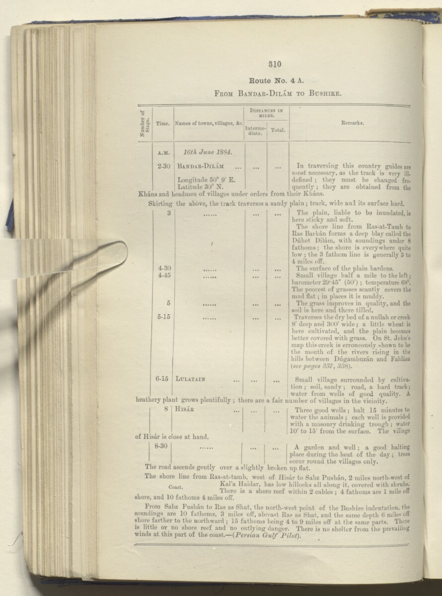
Route No. 4 A.
From Bandar-Dilam to Bushire.
Distances in
MILKS.
Time.
Names of towns, villages, &e.
Interme
diate.
Total.
A.M.
16th June 1884.
2-30
Bandar-Dilam
...
...
Longitude 50° 9' E.
Latitude 30° N.
Remarks.
In traversing this country guides are
most necessary, as the track is very ill.
defined ; they must be changed fre
quently ; they are obtained from the
Khans and headmen of villages under orders from their Khans.
Skirting the above, the track traverses a sandy plain ; track, wide and its surface hard.
The plain, liable to bo inundated, is
here sticky and soft.
The shore line from Ras-at-Tamb to
Itas Barkan forms a deep blay called the
Duhet Dilarn, with soundings under 8
fathoms; the shore is everywhere quite
low ; the 3 fathom line is generally 3 to
4 miles off.
The surface of the plain hardens.
Small village half a mile to the left;
barometer 29*45" (50') ; temperature 68°.
The poorest of grasses scantly covers the
mud flat ; in places it is muddy.
The grass improves in quality, and the
soil is here and there tilled.
Traverses the dry bed of a nullah or creek
8' deep and 300' wdde ; a little wheat is
here cultivated, and the plain becomes
better covered with grass. On St. John’s
map this creek is erroneously shown to be
the mouth of the rivers rising in the
hills between Dugambuzan and Fabliau
[see pages 337, 338).
6-15 Ltjlatain | Small villa ge surrounded by cultiva
tion; soil, sandy ; road, a hard track;
water from wells of good quality. A
heathery plant grows plentifully ; there are a fair number of villages in the vicinity.
4-30
4-45
5-15
8
Hisae
of Hisar is close at hand.
8-30
Three good wells ; halt 15 minutes to
water the animals ; each well is provided
with a masonry drinking trough ; water
10' to 15' from the surface. The village
A garden and well; a good halting
place during the heat of the day ; trees
occur round the villages only.
The road ascends gently over a slightly broken up flat.
The shore line from Ras-at-tamb, west of Hisar to Sabz Pushan, 2 miles north-west of
Coast Kal’a Haidar, has low hillocks all along it, covered with shrubs.
There is a shore reef within 2 cables ; 4 fathoms are 1 mile off
shore, and 10 fathoms 4 miles off.
From Sabz Pushan to Ras as Shat, the north-west point of the Bushire indentation, the
soundings are 10 fathoms, 3 miles off, abreast Ras as Shat, and the same depth 6 miles off
shore farther to the northward ; 15 fathoms being 4 to 9 miles off at the same parts. There
is little or no shore reef and no outlying danger. There is no shelter from the prevailing
winds at this part of the coast.—(Persia?* Gulf Pilot).
حول هذه المادة
- المحتوى
تقرير موسوم بأنه سريّ للغاية، أعدّه مساعد قائد الإمداد والتموين، الرائد الحاصل على ترقية استثنائية لرتبة مقدم مارك سيفر بيل من المهندسين الملكيين، في فرع المخابرات التابع لإدارة الإمداد والتموين. نشر المجلد مطبعة الفرع المركزي للحكومة، شيملا، ١٨٨٥.
تتلخص محتويات المجلد فيما يلي:
- الجزء I، وصف سردي لرحلة من الهند إلى المحمرة [خرمشهر]، وإلى قم عبر تلال لورستان؛ من قم إلى كلبايكان، وتشمان سلطان، وأليغودرز، وإمامزاده إسماعيل، ونهر زاينده، إلى أصفهان: ومن أصفهان إلى بهبهان وبندر ديلم عبر تلال كهكيلويه؛ من بندر ديلام إلى بوشهر
- الجزء II، وصف مفصل لجنوب غرب بلاد فارس، تم جمعه من ملاحظات سيفر الخاصة وغيرها من المصادر المتاحة
- الجزء III، الاعتبارات التجارية. هناك جزء آخر في هذا الفصل بشأن الملاحظات الاستراتيجية، التي ذُكرت في صفحة المحتويات ووُسمت بأنها سرية، غير موجود في المجلد
- الجزء IV، تقارير مفصّلة عن الطرق
- الملحق خريطة صغيرة أو صورة أخرى محاطة بهامش خريطة أكبر أو خريطة مفردة أو صورة أكبر؛ أو أوراق موضوعة داخل كتاب أو مجلد أرشيفي. أ، تقارير عن الطرق، من أصفهان إلى تُستر، ومنها إلى شيراز، جمعها في سنة ١٨٨١ النقيب هنري ليك ويلز، مساعد مدير إدارة التلغراف الفارسية، مع تعليقات إضافية بقلم بيل.
- الملحق خريطة صغيرة أو صورة أخرى محاطة بهامش خريطة أكبر أو خريطة مفردة أو صورة أكبر؛ أو أوراق موضوعة داخل كتاب أو مجلد أرشيفي. ب، قائمة بعينات نباتية جُمعت في لورستان خلال شهرَي أبريل ومايو ١٨٨٤
- الملحق خريطة صغيرة أو صورة أخرى محاطة بهامش خريطة أكبر أو خريطة مفردة أو صورة أكبر؛ أو أوراق موضوعة داخل كتاب أو مجلد أرشيفي. ج، مقتطفات من مقالة عن جيولوجيا الحدود التركية-الفارسية، بقلم ويليام كينيت لوفتوس، يونيو ١٨٥٤
- الملحق خريطة صغيرة أو صورة أخرى محاطة بهامش خريطة أكبر أو خريطة مفردة أو صورة أكبر؛ أو أوراق موضوعة داخل كتاب أو مجلد أرشيفي. د، ملاحظات عن الأرصاد الجوية في بوشهر، من ٢٠ مارس إلى ٢٠ يونيو ١٨٨٥
يتضمن المجلد ثماني خرائط، ولوحتين فوتوغرافيتين، ورسوم توضيحية (طوبوغرافية، ومعمارية، وأنثروبولوجية). يعود تاريخ اللوحتين الفوتوغرافيتين وبعض الخرائط لفترة تسبق تاريخ نشر المجلد في سنة ١٨٨٥.
- الشكل والحيّز
- مجلد واحد (٢٣١ ورقة)
- الترتيب
توجد صفحة بالمحتويات (ص. ٧) وفهرس (صص. ٢٢٢-٢٢٦)، ويشير كلاهما إلى ترقيم الصفحات الأصلي المطبوع للمجلد.
- الخصائص المادية
ترقيم الأوراق: يبدأ تسلسل ترقيم الأوراق (المستخدم للأغراض المرجعية) على الغلاف الأمامي بالرقم ١، وينتهي داخل الغلاف الخلفي بالرقم ٢٣٣؛ هذه الأرقام مكتوبة بالقلم الرصاص ومحاطة بدائرة في أعلى يمين صفحة الوجه الجانب الأمامي للورقة أو لفرخٍ من الورق. كثيرًا ما يشار إليه اختصارًا بالحرف "و". من كل ورقة.
ترقيم الصفحات: يتضمن الملف أيضًا تسلسل ترقيم صفحات أصلي مطبوع.
- لغة الكتابة
- الإنجليزية بالأحرف اللاتينية للاطّلاع على المعلومات الكاملة لهذا السجل
استخدام وإعادة نشر هذه المادة
- إعادة نشر هذه المادة
"تقرير عسكري عن جنوب غرب بلاد فارس، بما في ذلك أقاليم خوزستان (عربستان)، لورستان، وجزء من فارس" [ظ١٧٣] (٤٧٠/٣٥١)و المكتبة البريطانية: أوراق خاصة وسجلات من مكتب الهندو IOR/L/MIL/17/15/9و مكتبة قطر الرقمية <https://www.qdl.qa/archive/81055/vdc_100048990083.0x000098> [تم الوصول إليها في ١٦ May ٢٠٢٤]
https://www.qdl.qa/العربية/archive/81055/vdc_100048990083.0x000098
يمكنك نسخ ولصق الفقرة التالية لتضمين الصورة في صفحة الويب الخاصة بك.
<meta charset="utf-8"><a href="https://www.qdl.qa/العربية/archive/81055/vdc_100048990083.0x000098">"تقرير عسكري عن جنوب غرب بلاد فارس، بما في ذلك أقاليم خوزستان (عربستان)، لورستان، وجزء من فارس" [<span dir="ltr">ظ١٧٣</span>] (٤٧٠/٣٥١)</a> <a href="https://www.qdl.qa/العربية/archive/81055/vdc_100048990083.0x000098"> <img src="https://iiif.qdl.qa/iiif/images/81055/vdc_100000000239.0x00012f/IOR_L_MIL_17_15_9_0381.jp2/full/!280,240/0/default.jpg" alt="" /> </a>
هذا التسجيل IIIF له ملف ظاهر متوفر كما يلي. إذا كان لديك عارض متوافق للصور يمكنك سحب الأيقونة لتحميله.https://www.qdl.qa/العربية/iiif/81055/vdc_100000000239.0x00012f/manifestافتح في المتصفح العامافتح في عارض IIIF ميرادورطرق إضافية لاستخدام صور الأرشيف الرقمي
حقوق النسخ والتأليف: كيفية استخدام هذا المحتوى
- رقم الاستدعاء
- IOR/L/MIL/17/15/9
- العنوان
- "تقرير عسكري عن جنوب غرب بلاد فارس، بما في ذلك أقاليم خوزستان (عربستان)، لورستان، وجزء من فارس"
- الصفحات
- داخلي-خلفي ،ظ٢٢٨:و٢١٠ ،ظ١٩٠:و٩٧ ،ظ٩٥:و٩٠ ،ظ٨٨:و٨٤ ،ظ٨٢:و٦٤ ،ظ٦٢:و١٣ ،ظ١١:و٢ ،داخلي-أمامي ،ذيل ،رأس ،حافة ،صلب ،خلفي ،أمامي
- المؤلف
- شركة الهند الشرقية ولجنة البرلمان البريطاني لشئون الهند ومكتب الهند وإدارات الحكومة البريطانية الأخرى
- شروط الاستخدام
- ترخيص حكومي عام