Sketch map of the Arabian coast between Al Katif and Ras Jibsk
Mss Eur F126/111


2 items in this record
Search within this record
The record is made up of 1 map. It was created in c 1860. It was written in English. The original is part of the British Library: India Office The department of the British Government to which the Government of India reported between 1858 and 1947. The successor to the Court of Directors. Records and Private Papers Documents collected in a private capacity. .
About this record
- Content
Distinctive Features:
Relief shown by shading and spot heights A point on a map at which the height of the land is recorded. .
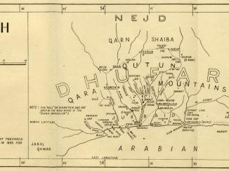
Hand drawn sketch map showing the Arabian coast of the Persian Gulf The historical term used to describe the body of water between the Arabian Peninsula and Iran. between Al Katif and Ras Jibsk. Notations concerning the topography of the region cover the face of the map with graticule A network of latitude and longitude lines. lines with degrees of latitude inserted in pencil.
- Extent and format
- 1 map
- Area map covers
- Map loading...
- Scale
- Scale not given
- Scale designator
- Horizontal
- Orientation
- North
- Degree coordinates
- Top-left: 26° 37' 12" N, 49° 44' 37.68" E
Top-right: 26° 37' 12" N, 59° 58' 48.72" E
Bottom-left: 21° 35' 59.64" N, 49° 44' 37.68" E
Bottom-right: 21° 35' 59.64" N, 59° 58' 48.72" E - Physical characteristics
Materials: Pen and ink with wash on paper
Dimensions: 395 x 730 mm
Foliation: The map has been foliated in the top right hand corner with a pencil number enclosed in a circle.
- Written in
- English in Latin script
- Type
- Map
Archive information for this record
- Original held at
- British Library: India Office The department of the British Government to which the Government of India reported between 1858 and 1947. The successor to the Court of Directors. Records and Private Papers Documents collected in a private capacity.
- Access conditions
Unrestricted
- Archive reference
- Mss Eur F126/111
- Date(s)
- c 1860 (CE, Gregorian)
Access & Reference
History of this record
Related search terms
- Places
- Oman
Use and share this record
- Share this record
- Cite this record in your research
Sketch map of the Arabian coast between Al Katif and Ras Jibsk, British Library: India Office Records and Private Papers, Mss Eur F126/111, in Qatar Digital Library <https://www.qdl.qa/archive/81055/vdc_100000001524.0x0003e2> [accessed 28 June 2026]
- Link to this record
https://www.qdl.qa/en/archive/81055/vdc_100000001524.0x0003e2
- IIIF details
This record has a IIIF manifest available as follows. If you have a compatible viewer you can drag the icon to load it.https://www.qdl.qa/en/iiif/81055/vdc_100000001524.0x0003e2/manifestOpen in Universal viewerOpen in Mirador viewerMore options for embedding images
Copyright: How to use this content
- Reference
- Mss Eur F126/111
- Title
- Sketch map of the Arabian coast between Al Katif and Ras Jibsk
- Pages
- 1r:1v
- Author
- Unknown
- Usage terms
- The copyright status is unknown. Please contact [email protected] with any information you have regarding this item.