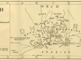
‘MAP OF OMÂN SHOWING DISTRIBUTION OF THE PRINCIPAL TRIBES. COMPILED FOR OFFICIAL USE BY Edward Charles ROSS, Political Agent, MUSCAT’
Mss Eur F126/54, f 6


2 items in this record
Search within this record
The record is made up of 1 map. It was created in 1872. It was written in English. The original is part of the British Library: India Office The department of the British Government to which the Government of India reported between 1858 and 1947. The successor to the Court of Directors. Records and Private Papers Documents collected in a private capacity. .
About this record
- Content
Distinctive Features:
Relief shown by hachures and spot heights.
Routes shown by dotted line with wells indicated. Names of tribes inserted on map in different colours showing their approximate location with a key provided in bottom left.
The coast and principal mountain peaks are taken from the chart by Constable and Stiffe; the interior from Welstead's map and the projections from those by E B Girdlestone. Ross has corrected spellings and made additions taken from 'native sources'.
Includes five tables listing names of tribes and details on their population and areas they inhabit.
- Extent and format
- 1 map
- Area map covers
- Map loading...
- Scale
- Scale approximately 1:1,000,000
- Scale designator
- Horizontal
- Orientation
- North
- Degree coordinates
- Top-left: 26° 28' 59.88" N, 53° 58' 37.92" E
Top-right: 26° 28' 59.88" N, 59° 56' 29.4" E
Bottom-left: 20° 59' 51" N, 53° 58' 37.92" E
Bottom-right: 20° 59' 51" N, 59° 56' 29.4" E - It is part of
- 14 imagesRef: Mss Eur F126/54
- Physical characteristics
Dimensions: 589 x 800 mm, on sheet 659 x 930 mm
- Written in
- English in Latin script
- Type
- Map
Archive information for this record
- Original held at
- British Library: India Office The department of the British Government to which the Government of India reported between 1858 and 1947. The successor to the Court of Directors. Records and Private Papers Documents collected in a private capacity.
- Access conditions
Unrestricted
- Archive reference
- Mss Eur F126/54, f 6
- Date(s)
- 1872 (CE, Gregorian)
Access & Reference
History of this record
Related search terms
- Places
- Oman
- People & organisations
- Sir Edward Charles Ross, Knight
Use and share this record
- Share this record
- Cite this record in your research
‘MAP OF OMÂN SHOWING DISTRIBUTION OF THE PRINCIPAL TRIBES. COMPILED FOR OFFICIAL USE BY Edward Charles ROSS, Political Agent, MUSCAT’, British Library: India Office Records and Private Papers, Mss Eur F126/54, f 6, in Qatar Digital Library <https://www.qdl.qa/archive/81055/vdc_100023399223.0x000001> [accessed 13 May 2024]
- Link to this record
https://www.qdl.qa/en/archive/81055/vdc_100023399223.0x000001
- IIIF details
This record has a IIIF manifest available as follows. If you have a compatible viewer you can drag the icon to load it.https://www.qdl.qa/en/iiif/81055/vdc_100000001524.0x0003c1/manifestOpen in Universal viewerOpen in Mirador viewerMore options for embedding images
Copyright: How to use this content
- Reference
- Mss Eur F126/54, f 6
- Title
- ‘MAP OF OMÂN SHOWING DISTRIBUTION OF THE PRINCIPAL TRIBES. COMPILED FOR OFFICIAL USE BY Edward Charles ROSS, Political Agent, MUSCAT’
- Pages
- 6r:6v
- Author
- East India Company, the Board of Control, the India Office, or other British Government Department
- Usage terms
- Open Government Licence